All Activity
- Past hour
-

Strong Nor'Easter/Hybrid Storm Late September 2026
mob1 replied to Rjay's topic in New York City Metro
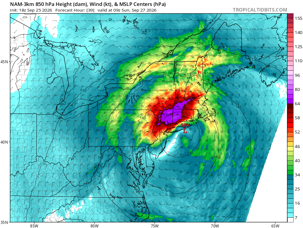
Not really the point, other models have it as well. You want the storm to move westward at the latitude of Ocean City and ideally before it occludes. The models that showed that earlier had the best winds Saturday night into Sunday..thumb.png.0f956fe8d693ebc234700595efae8b25.png)
-

October Comes Early: Late September Multi-Hazard Hybrid Storm
TalcottWx replied to WxWatcher007's topic in New England
Eversource CT just posted about hiring contractors. -
October Comes Early: Late September Multi-Hazard Hybrid Storm
TalcottWx replied to WxWatcher007's topic in New England
Always -
MDT might get 3/4” inch Sunday. There goes my concert.
-
 Weed?
Weed? -
All know pressure on that is usually way overdone for systems. Has hurricanes like 50mb deeper than they are half the time lol
-

October Comes Early: Late September Multi-Hazard Hybrid Storm
rclab replied to WxWatcher007's topic in New England
At my age it would make me happy, as always ….. -
Hurricane Polo Discussion Number 21 NWS National Hurricane Center Miami FL EP172026 200 PM MST Fri Sep 25 2026 A NOAA research aircraft has found that Polo remains a very powerful category 5 hurricane. The highest flight level winds measured by the aircraft were 165 kt in the northeast quadrant, and since that measurement the central pressure has decreased a couple millibars, to 913. An UAS launched from the plane measured a peak wind just above 200 kt at an altitude just below 500 m, which corresponds to a 10 m wind of 150-155 kt based on an experimental wind reduction model. Taken all together, this data supports an initial intensity of 155 kt. The NOAA aircraft reported that there may be signs of an eyewall replacement cycle beginning. Although this does not appear to be having an impact on the hurricane yet, it does highlight that fluctuations in the intensity of Polo are likely over the next 24 h while it remains over warm waters. After that, some weakening is expected as Polo begins to move into a region with lower ocean heat content and the vertical wind shear increases slightly. However, it is expected to remain a powerful major hurricane through the weekend. The NHC intensity forecast is still near the upper-end of the intensity guidance and is very similar to the previous advisory. Only small adjustments were made to the official track forecast, with the biggest change being that the anticipated forward motion for Polo is slightly faster in this advisory. Polo is still expected to turn gradually northwestward, then northward this weekend as it moves around the western side of a ridge centered over northern Mexico. Then early next week an upper-level trough approaching from the northwest will likely cause the hurricane to turn northeastward toward Baja California Sur and west-central Mexico. The AI models, notably GDM and the experimental WeatherNext3, generally show a slightly faster motion than most of the dynamical guidance, and the model spread has increased at 72 h and beyond. The forecast confidence is correspondingly lower with this advisory. The NHC forecast is a blend of the consensus and continuity with the previous advisory. Based on the forecast track, watches could be required for portions of Baja California Sur as soon as tonight. Distant moisture from Hurricane Polo and Odalys will be transported into the southwestern United States this weekend and early next week, and may indirectly contribute to a heavy rainfall and flash flood threat in the region. See products issued by the Weather Prediction Center for more information. Key Messages: 1. Polo is forecast to approach the Baja California Peninsula early next week as a hurricane. Interests there should closely monitor the latest updates and ensure that they have their preparedness plan in place. Watches could be required as early as tonight for portions of the area. 2. Heavy rainfall associated with Polo may begin to impact Baja California Sur late Sunday into Monday. This rainfall may produce life-threatening flooding and mudslides, especially in areas of steep terrain. FORECAST POSITIONS AND MAX WINDS INIT 25/2100Z 17.2N 109.2W 155 KT 180 MPH 12H 26/0600Z 17.4N 110.6W 150 KT 175 MPH 24H 26/1800Z 18.2N 112.1W 140 KT 160 MPH 36H 27/0600Z 19.6N 113.2W 125 KT 145 MPH 48H 27/1800Z 21.5N 113.7W 115 KT 130 MPH 60H 28/0600Z 23.4N 113.6W 100 KT 115 MPH 72H 28/1800Z 25.1N 112.8W 95 KT 110 MPH 96H 29/1800Z 28.5N 109.7W 60 KT 70 MPH...INLAND 120H 30/1800Z 32.0N 105.5W 25 KT 30 MPH...POST-TROP/INLAND $$ Forecaster D. Zelinsky
-

Strong Nor'Easter/Hybrid Storm Late September 2026
SnoSki14 replied to Rjay's topic in New York City Metro
Current satellite looks pretty impressive. The prolonged nature of this plus high tide I think guarantees several places meet major coastal flood category. -
.thumb.jpg.6a4895b2a43f87359e4e7d04a6fa0d14.jpg)
Central PA Autumn 2026
Yardstickgozinya replied to canderson's topic in Upstate New York/Pennsylvania
National Weather Service State College PA 153 PM EDT Fri Sep 25 2026 .WHAT HAS CHANGED... * Increased wind gusts and POPs/QPF this weekend * Stratified wx to rain vs. rain showers * Lowered maxT Sunday && .KEY MESSAGES... 1) Nor`easter will bring gusty winds and periods of rain for the first weekend of Fall && .DISCUSSION... KEY MESSAGE 1: Nor`easter will bring gusty winds and periods of rain for the first weekend of Fall Sensible weather conditions continue to trend incrementally bearish on the margin particularly later Saturday through Sunday as wind and rain impacts extend westward from powerful Nor`easter tracking toward the NJ/Long Island/southern New England coast. Latest model guidance favored a minor increase in wind gusts and westward expansion of higher POPs/QPF to the Allegheny Front. Locations throughout the Susquehanna Valley will see the most persistent rain and strongest wind gusts up to 40 mph. We lowered max temps a few degrees Sunday due to the combination of clouds, wind, and rain. We can`t rule out some localized/minor impacts (sporadic power outages and tree damage) due to the wind gusts especially across the eastern portions of the CWA. It`s still hard to say how far west the precip will reach with the western Alleghenies most likely to continue an extended dry stretch through much of next week. As the nor`easter lifts to the northeast, conditions should steadily improve by the middle of next week with temperatures poised to rebound above the historical average for the end of September. && .AVIATION /18Z FRIDAY THROUGH WEDNESDAY/... Prevailing VFR flight cats through tonight with increasing high to mid level clouds from southeast to northwest. Localized vis restrictions may occur in valley fog tonight and have kept mention of VCFG at western and central airfields. LLWS forecast throughout ZNY sector tonight as a 45-60 knot low level jet moves into the area on the west-side of powerful Nor`easter. Rain could reach KMDT/KLNS by Saturday afternoon/evening. Highest confidence in sub-VFR will be over the eastern half of the airspace through Sunday. Winds/gusts from 330-030 degrees will increase Saturday into Sunday maxing out around 30kts. Outlook... Mon-Wed...Improving conditions trending VFR by midweek. && .CTP WATCHES/WARNINGS/ADVISORIES... None. -
October Comes Early: Late September Multi-Hazard Hybrid Storm
EastonSN+ replied to WxWatcher007's topic in New England
I hope they are pulling in power crews from other states. -

Strong Nor'Easter/Hybrid Storm Late September 2026
NJwx85 replied to Rjay's topic in New York City Metro
What’s interesting to me is that this sounding shows the atmosphere is well mixed and there’s no inversion. Notice how the dew point and temperature are very close together near the surface. This means winds will have no trouble mixing down. -

October Comes Early: Late September Multi-Hazard Hybrid Storm
cut replied to WxWatcher007's topic in New England
I just looked as well. Cool stuff. -
Per my NWS forecast, I could see a high end qpf of 1.5" from this storm. Wind here gusts to 30mph, but not likely in my sheltered backyard.
-
Strong Nor'Easter/Hybrid Storm Late September 2026
NJwx85 replied to Rjay's topic in New York City Metro
Please stop posting the 3k NAM unless it’s for entertainment only. -
Strong Nor'Easter/Hybrid Storm Late September 2026
mob1 replied to Rjay's topic in New York City Metro
Hi Res NAM (and some other models) have this occurring a bit further north and has much tamer winds than some earlier runs. We'll see if it was just a blip but often as these events approach they trend a bit NE and weaker so we get a bit of a lackluster storm relative to expectations. We'll see how it unfolds, but personally I much prefer the 12Z NAM runs (despite sputting out far less precipitation. Rain events are a dime a dozen, good wind and coastal flooding is somewhat rarer).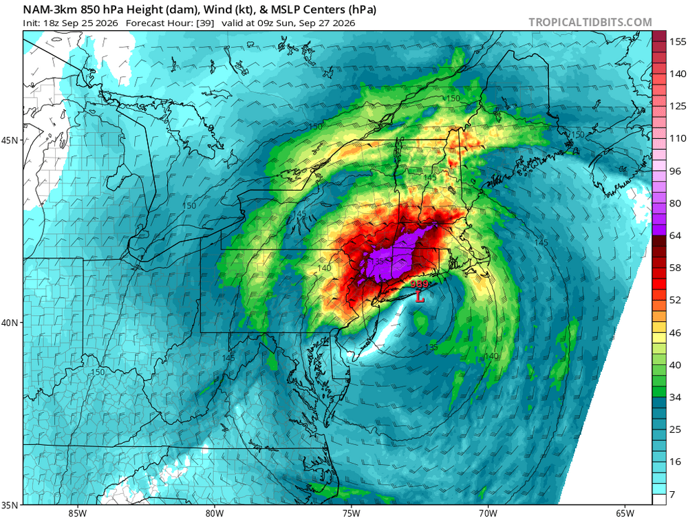
-

Strong Nor'Easter/Hybrid Storm Late September 2026
IrishRob17 replied to Rjay's topic in New York City Metro
Orange County recently posted this in an attempt to get people to understand them better.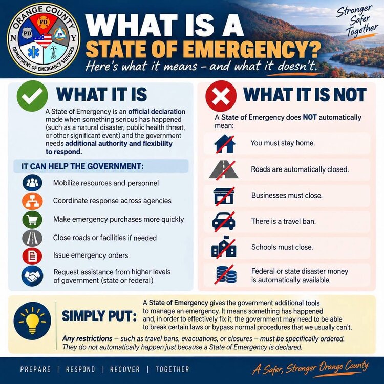
-
October Comes Early: Late September Multi-Hazard Hybrid Storm
TalcottWx replied to WxWatcher007's topic in New England
I was driving on Hoskins Rd to my house on Tuesday and an acorn hit my windshield so hard I thought I was taking fire. -

October Comes Early: Late September Multi-Hazard Hybrid Storm
Lava Rock replied to WxWatcher007's topic in New England
Gonna get porked on the rain Sent from my SM-S921U using Tapatalk -

October Comes Early: Late September Multi-Hazard Hybrid Storm
UnitedWx replied to WxWatcher007's topic in New England
Acorns are on a mission this fall. We've needed our hard hats on a couple outdoor jobs already -

Strong Nor'Easter/Hybrid Storm Late September 2026
EasternLI replied to Rjay's topic in New York City Metro
Ouch. Tomorrow night is really going to rip some winds through here. This is from the euro. 925mb plus a sounding from the same time. I usually feel like winds are whatever, but this time it looks kind of legit. Nam just spit out something similar too. -

2026-2027 Record-breaking El Nino
GaWx replied to Stormchaserchuck1's topic in Weather Forecasting and Discussion
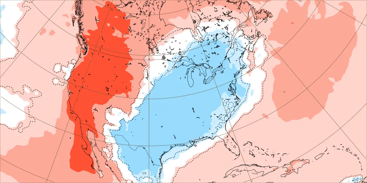
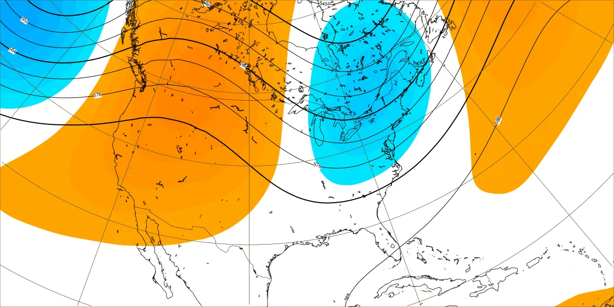
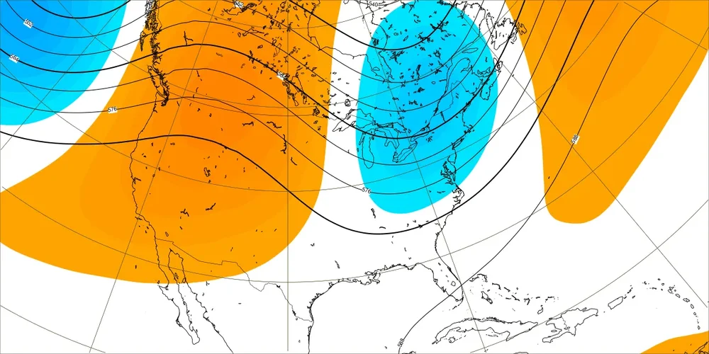
Thank you! I had a brain malfunction! I edited my original post to point to the error and correction of dates. I apologize for my mistake. The new map for Oct 5-11 has a slightly stronger cold signal than yesterday’s: H5: @mitchnick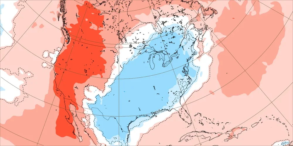
-

Strong Nor'Easter/Hybrid Storm Late September 2026
MJO812 replied to Rjay's topic in New York City Metro
Tunnels to towers 5k walk/ run is still going on Sunday. I will be participating in it. Going to be interesting weather wise. -
We have a lot of movement below the belt
-

Strong Nor'Easter/Hybrid Storm Late September 2026
psv88 replied to Rjay's topic in New York City Metro
WHAT...For the High Surf Advisory, large breaking waves of 9 to 15 feet in the surf zone. For the High Rip Current Risk, dangerous rip currents. For the Coastal Flood Advisory, up to one half foot of inundation above ground level expected in vulnerable areas near the waterfront and shoreline. For the Coastal Flood Warning, one to two feet of inundation above ground level expected in vulnerable areas near the waterfront and shoreline.
.png.f4e91e01d9944c46a21209e75897329c.png)