All Activity
- Past hour
-
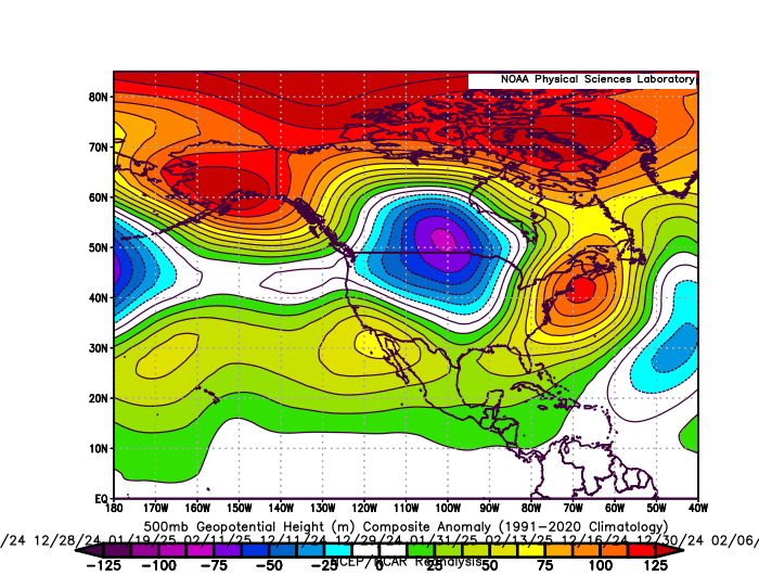
It was mostly that the +PNA was getting undercut by the very fast Pacific Jet. The composite below is for the heaviest precipitation days last winter from Philly to Boston. The energy diving into the trough to our west during the storms pumped the Southeast ridge allowing the wettest storms to cut to our west.
-
Agree 100%. I have come across quite a few hot summers and mild, snowless winters from the 1800s-1860s, but with lack of official records, they are never looked at beyond what minimal info there is.
-
Plenty to do and talk about, What a great stretch of fall weather, Dry but comfortable to get chores done.
-
No offense bro but thank god you’re not running the team. Jalen Carter is a generational DT talent. You don’t give those away. Not to mention safety is one of the lowest positional values in the league. You’re not getting a player of Carter’s caliber back even if you got 10 first rounders. That’s why I laugh at what GB paid for Parsons. That is absolutely nothing for a generational pass rusher. They don’t grow on trees and they aren’t available every draft. There is no trade of Jalen Carter that doesn’t make the team significantly worse.
-

E PA/NJ/DE Autumn 2025 Obs/Discussion
The Iceman replied to PhiEaglesfan712's topic in Philadelphia Region
Last fall repeat and ngl im here for it. Endless sunny and 70’s days and low 50/upper 40 nights. Let’s keep this going until about mid November. -
A Steining to remember.
-
I played there years ago for a friend's bachelor party. I'd like to go back, I remember it as being a nice course.
-

2025-2026 ENSO
40/70 Benchmark replied to 40/70 Benchmark's topic in Weather Forecasting and Discussion
Mentioned before, I am confident this will be BS this season. Will revisit next spring. -
September is the sunniest month here, followed in order by August and July.
-
2025-2026 ENSO
40/70 Benchmark replied to 40/70 Benchmark's topic in Weather Forecasting and Discussion
It didn't work out because the PNA ridges consistently posituioned off of the west coast. Put it over the chinmey of Idaho and it will work. -
If you want to see a lot of them, look for the also invasive Tree of Heaven. They love those suckers (pun intended).
-
2025-2026 ENSO
40/70 Benchmark replied to 40/70 Benchmark's topic in Weather Forecasting and Discussion
I think the PNA will be volatile and average near neutral...we should be a big +month in January that will coincide with +NAO. -

September 2025 OBS-Discussion centered NYC subforum
bluewave replied to wdrag's topic in New York City Metro
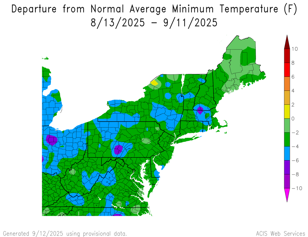
The recent dry pattern stretching back to last summer has mostly affected the soil moisture and vegetation. It was really only parts of NJ that had issues with the very low reservoirs last fall. As the NYC watershed upstate didn’t run into any low water supply issues. Long range precipitation forecasting is very low skill. We had a 500 year drought back in the 1960s followed by a steady increase in rainfall. While the drought from 1999-2002 did result in NYC watershed restrictions and low reservoir levels, it wasn’t as bad as the 1960s. We entered a much wetter pattern back in 2003. All our dry periods since then have been short and the rebound to wetter following them was more impressive. So we will need more time to see if the major drought covering Canada and parts of the CONUS is some type of new pattern the last few years. In the mean time the dry pattern has been influencing or daily temperature range. The low temperatures have been running significantly cooler than the highs. So this has lead to the great radiational cooling in places like Walpack, NJ. But the high temperatures have been beating guidance on the days with close to full sun and offshore flow.
-
Our great stretch of weather continues this weekend. We should see above normal temperatures near 80 degrees through Monday. We fall back close to normal with highs in the mid to upper 70's by Tuesday. Our very dry weather unfortunately continues for at least the next week.

-
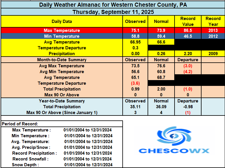
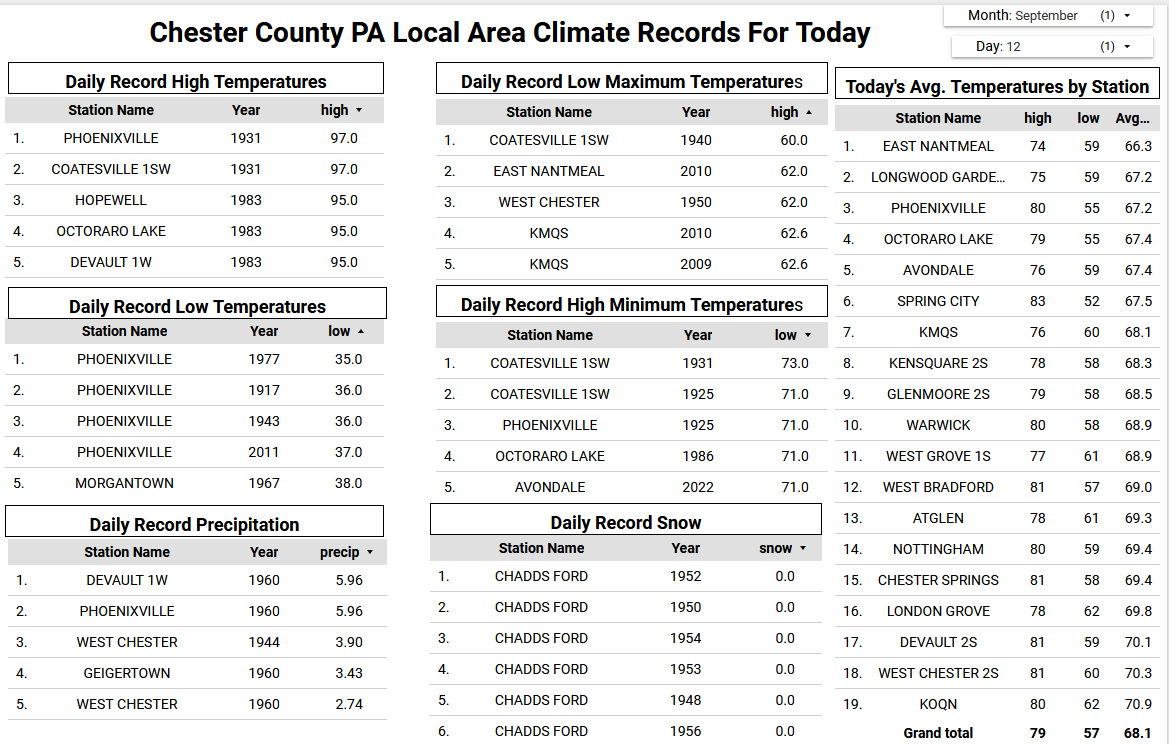
(002).thumb.png.6e3d9d46bca5fe41aab7a74871dd8af8.png)
E PA/NJ/DE Autumn 2025 Obs/Discussion
ChescoWx replied to PhiEaglesfan712's topic in Philadelphia Region
Our great stretch of weather continues this weekend. We should see above normal temperatures near 80 degrees through Monday. We fall back close to normal with highs in the mid to upper 70's by Tuesday. Our very dry weather unfortunately continues for at least the next week.
-
Still no significant precip
.gif.d54c288d8036d161c14a5350bd0c89c7.gif)
-
Lanternflies must have amazing radar reflective properties. When the cicadas did this, you’d see hordes flying around. Certainly there are lots of lanternflies, but nothing like the cicadas…at least where I travel and live.
-
Highest heat stays West next week due to the Omega block.
.thumb.png.3d54a8e3269c0f4a93d493260e24c79c.png)
-
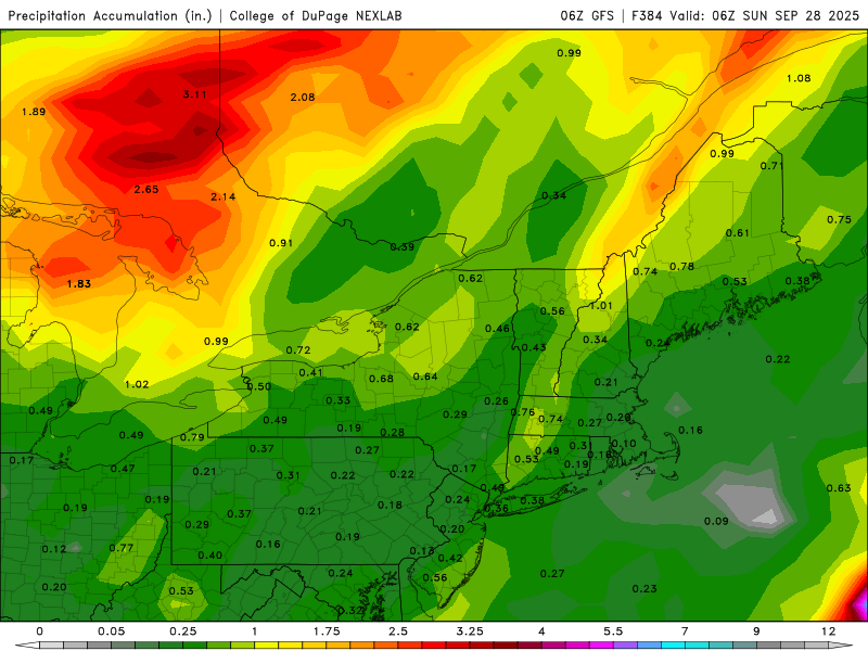
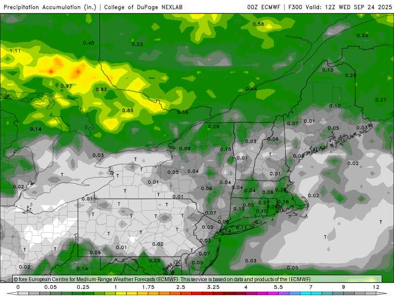
I would normally laugh at posting op runs of total qpf, but almost every run of every model has looked like this for days
- Today
-

September 2025 OBS-Discussion centered NYC subforum
Sundog replied to wdrag's topic in New York City Metro
Sunday looks a bit tricky, Euro is the warmest while other models have mnore onshore flow like buewave said might happen. -
That’s pretty crazy. Thanks.
-
The weather doesn’t get more boring than this. There is literally nothing to talk about.
-
2025-2026 ENSO
40/70 Benchmark replied to 40/70 Benchmark's topic in Weather Forecasting and Discussion
I prefer to study females, but you do you. -
2025-2026 ENSO
40/70 Benchmark replied to 40/70 Benchmark's topic in Weather Forecasting and Discussion
https://psl.noaa.gov/data/atmoswrit/map/index.html -

September 2025 OBS-Discussion centered NYC subforum
ILoveWinter replied to wdrag's topic in New York City Metro
Thanks you for the perspective on the "drought"! Completely agree, we in this forum sometimes are overly concerned during dry stretches. There may be a time to worry but now is not it.


.png.6cf2c4bb26de106891c25d1b11e5c49a.png)

