All Activity
- Past hour
-
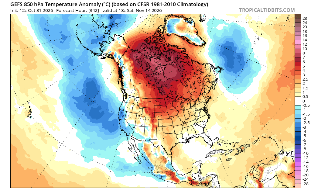
hm not aware of any teleconnectors for the latter half of November but from 7th to 16th or so, that's not really a cold pattern. The teleconnectors for that earlier time range are indeed -AO/+PNA ...but this is one of those situations where the numerology is lying about the super synoptic aspects, and the actual mean spatial layout. The +PNA is almost all being caused by strong neg anomalies NE of Hawaii...but the flow subtending down stream over the Conus is very zonal... so it's misleading to some degree. As to the -AO...that's suspicious too. The actual orientation of the heights/contouring show an annular structure about the AO domain, but the domain itself happens to have modest positive anomalies. That's the problem with using strictly the geopotential anomalies to compute the orthogonal/eof derivatives, particularly when the height everywhere about a coffee break from kicking off the super extinction event
-
Wonder if anbody stopped and wondered what will happen if they issue a stop-payment on their subscription?
-
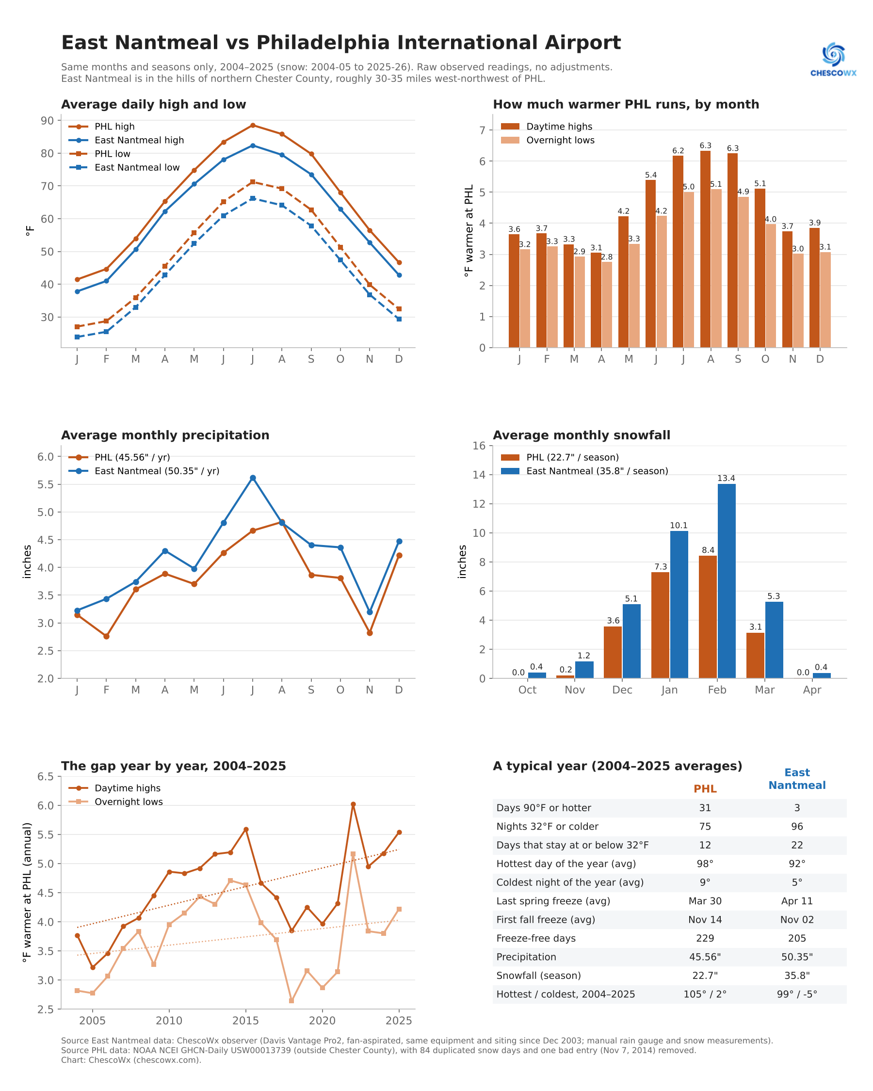
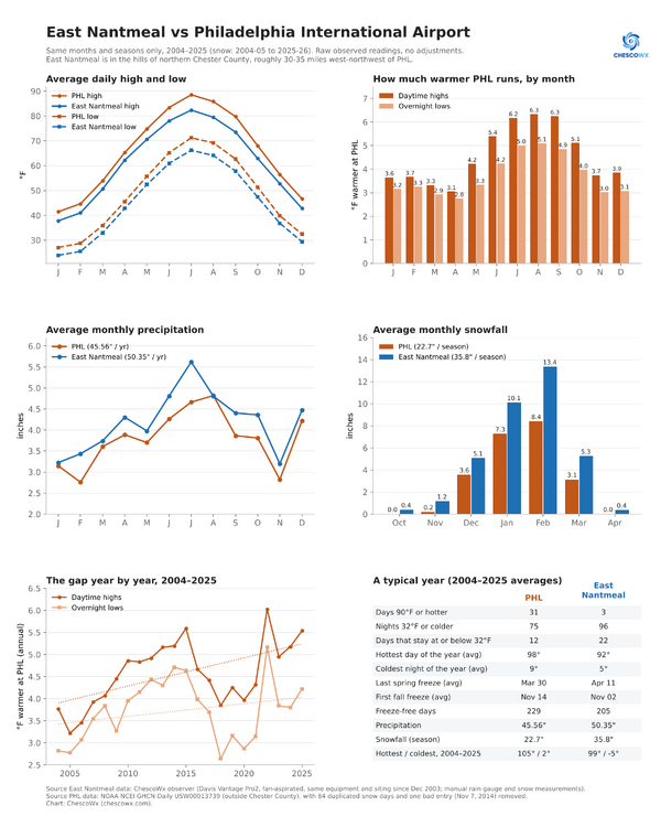
I was asked to compare PHL Airport vs East Nantmeal Twp. In the western philly burbs of Chester County PA for climate since 2004. (see full panel below) Summer afternoons: PHL’s highs run 5.4–6.3°F warmer from June through September. Against the whole county the gap was mainly at night; against East Nantmeal it’s mainly in the daytime. That fits what the siting check found: my fan-aspirated Davis records cool highs. Elevation adds to it. Overnight lows: PHL is warmer every month, from 2.8°F in April to 5.1°F in August. Rain and snow: Precipitation: East Nantmeal gets 50.35" a year to PHL’s 45.56". It’s wetter in most months, especially July (5.62" vs 4.66"). Snow: East Nantmeal averages 35.8" a season against 22.7" at PHL, about 58% more. EN had more snow than PHL in all 22 seasons. February shows the biggest difference: 13.4" vs 8.4". Is the temperature gap widening? Yes. It has grown about 0.46°F per decade, mostly in daytime highs (+0.64). PHL warmed about 1.0°F per decade over these 22 years, against 0.55 at East Nantmeal. I will post up Chester County as a whole later. Let me know if any questions. Thanks!
-

E PA/NJ/DE Autumn 2026 Obs/Discussion
ChescoWx replied to PhiEaglesfan712's topic in Philadelphia Region
I was asked to compare PHL Airport vs East Nantmeal Twp. In the western philly burbs of Chester County PA for climate since 2004. (see full panel below) Summer afternoons: PHL’s highs run 5.4–6.3°F warmer from June through September. Against the whole county the gap was mainly at night; against East Nantmeal it’s mainly in the daytime. That fits what the siting check found: your fan-aspirated Davis records cool highs. Elevation adds to it. Overnight lows: PHL is warmer every month, from 2.8°F in April to 5.1°F in August. Rain and snow: Precipitation: East Nantmeal gets 50.35" a year to PHL’s 45.56". It’s wetter in most months, especially July (5.62" vs 4.66"). Snow: East Nantmeal averages 35.8" a season against 22.7" at PHL, about 58% more. EN had more snow than PHL in all 22 seasons. February shows the biggest difference: 13.4" vs 8.4". Is the temperature gap widening? Yes. It has grown about 0.46°F per decade, mostly in daytime highs (+0.64). PHL warmed about 1.0°F per decade over these 22 years, against 0.55 at East Nantmeal. I will post up Chester County as a whole later. Let me know if any questions. Thanks!
-
maybe warmer? gw/cc
-
Spectacular mid fall day today.
-
I guess a few post-frontal days in the 40's could be considred "cold" if your avg is 52
-
1877-78 incoming?
-
Hopefully you miss!
-
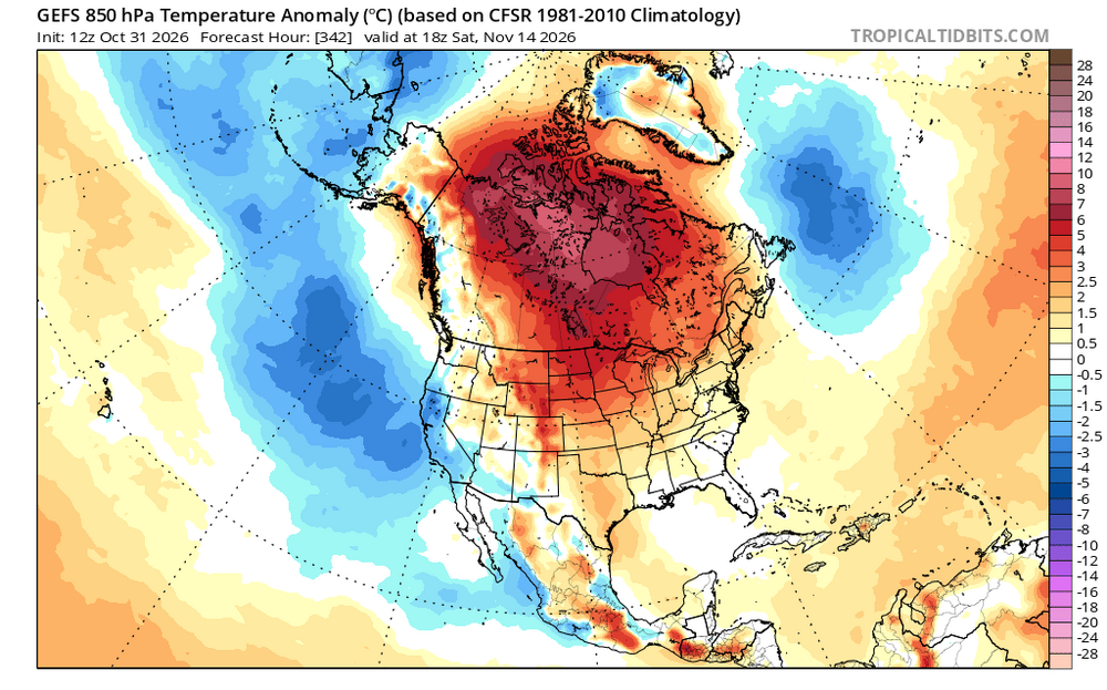
brings down the cool...no cold to be had
-
clouds over the top of RMNP but not snow
-
 https://zenithindusrx.shop/# indian pharmacies
-
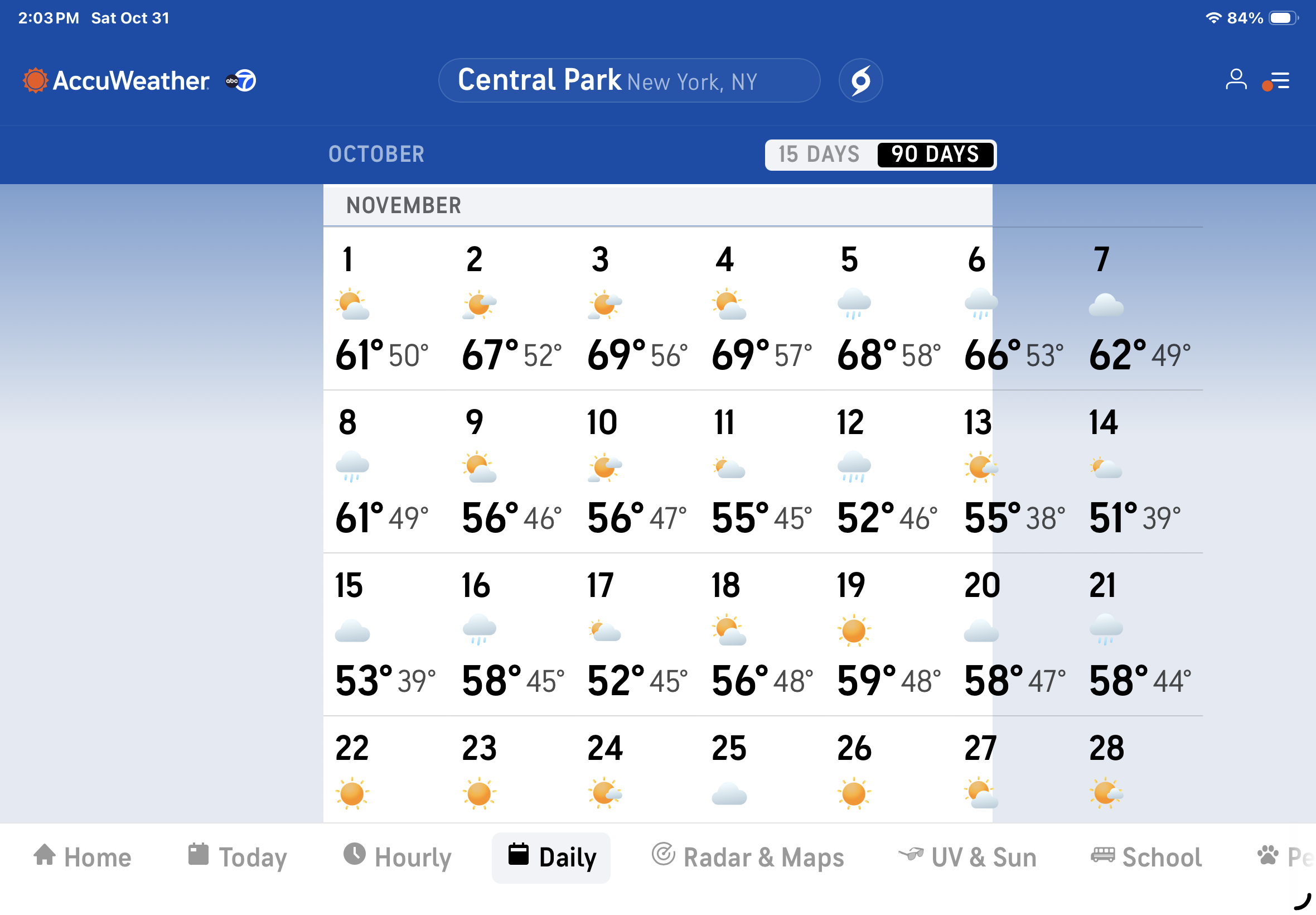
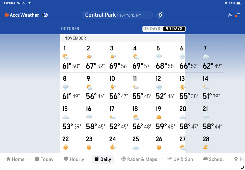
Accuweather long range seems to follow the same curve. As always …….
-
4.5 hours leaf blowing today , absolute disaster
-
Is Burt Reynolds with you there?
-
A warmer Canada is colder than Tolland.
-
online pharmacy in mexico: cheapest mexican pharmacy online - cheapest mexican prescription drugs
-
effects of the ssw already being felt, normally models would come out earlier starting the second week of november
-
Correct - plus all these above average temp months in a row and this abnormally long stretch of spring/summer like weather the last couple of weeks is giving some folks a false sense of security that EL NINO will protect us from the cold and snow well into winter..............
-
Long range gfs brings down the cold
-
December is so far away . No one has a clue yet that far. Long range forecasting hasn't been right in years.
-
Models come out earlier tomorrow
-
Judah Cohen says the models don't have a handle on this set up yet - he has an interview video which I can't post here for some reason on FOX. He is not sure what might happen yet going into December.
-

Fall 2026 Medium/Long Range Pattern Thread
Carvers Gap replied to John1122's topic in Tennessee Valley
LR ext modeling (Euro and GFS) are starting to show a cool down(significant?) in the last week of November to BN temps. Shoulder season modeling should be taken with a grain of salt FWIW. However, both show winter arriving on time ironically (after all of this warm wx). LR ext modeling was wrong about October being cold, so buyer beware! - Today
-
Good luck!!