All Activity
- Past hour
-

The “I bring the mojo” Jan 30-Feb 1 potential winter storm
BornAgain13 replied to lilj4425's topic in Southeastern States
6z Icon finally getting a clue.thumb.png.9039be8b7c50f6b4f8a63d404e0c2154.png)
-

E PA/NJ/DE Winter 2025-26 Obs/Discussion
Duca892 replied to LVblizzard's topic in Philadelphia Region
Stolen from our friends in MA forum. That’s uh quite the hill to be on when literally nothing is showing that at like 84hrs out lol -

The Jan 31 Potential: Stormtracker Failure or 'Tracker Trouncing
Roger Smith replied to stormtracker's topic in Mid Atlantic
06z NAM seems a bit slower and weaker by end of run than its 00z counterpart was. Probably not much of a clue since it hadn't reached the explosive development phase by 18z Saturday. -
The “I bring the mojo” Jan 30-Feb 1 potential winter storm
BornAgain13 replied to lilj4425's topic in Southeastern States
SREF through 1 PM Saturday..thumb.png.bf83a80548ab47671b2dad4eb0da530f.png)
-
I feel completely opposite versus last weekend's lead time into the event for a snow storm. Obviously, that transitioned into worry for the ice storm. But with respect to all snow, perhaps even significant totals, my confidence is growing. Got to love recent trends with a stronger and slower mid-to-upper low versus the coastal surface low. If the moisture feed is there, that ULL will eat. Very cold column and high ratios. I guess if I get my heart broken, so be it. I am all in on this system.
-

Possible coastal storm centered on Feb 1 2026.
moneypitmike replied to Typhoon Tip's topic in New England
Rule number one of weenie forecasting: Ride the model that provides snow. Rule number two of weenie forecasting: Toss anything that doesn't. Rule number three of weenie forecasting: Say "these always come north/south/east/west" (whichever correction says snow. -
RGEM takes the ULL from Memphis to North Alabama, and it's stronger than it was at 0z. Still snowing over the eastern half of the state with 1-3 inches down from Nashville to Cookeville, and 3-5 inches down from Cookeville eastward.
- 9 replies
-
- 1
-

-
- extreme cold
- snow
- (and 1 more)
-
The Jan 31 Potential: Stormtracker Failure or 'Tracker Trouncing
Duca892 replied to stormtracker's topic in Mid Atlantic
That’s uh quite the hill to die on lol -
A lot of us just received 15-18 inches of snow and the temperature never went above 12. Do better than it's too cold.
-
RGEM looks like it's winding the vort up tighter further NW as well vs 0z. The ICON, while not quite enough for most of us, jumped west 200 miles.
- 9 replies
-
- 1
-
-
- extreme cold
- snow
- (and 1 more)
-

2025-2026 Fall/Winter Mountain Thread
franklin NCwx replied to Buckethead's topic in Southeastern States
6z nam digging farther west and closing off over the Tennessee, Bama, and Mississippi border at 84! Would be a great run for us afterwards -
Ratios are 17 to 20:1 on the NAM across the state as snow is falling. Just south of Nashville, and in NE Tn from earlier snow, 4-6 inches have fallen at 84 and it's still snowing over the eastern 2/3rds of the forum area. Alabama and Georgia are in the game.
-
In response, we are getting nammed, almost state wide by 78. Looks like the RGEM.
-
The NAM is winding our energy up over Eastern Kansas/Western Missouri at 06z, 72hrs, at 78 at 0z it wasn't quite wound yet and was over SE Missouri.
- Today
-

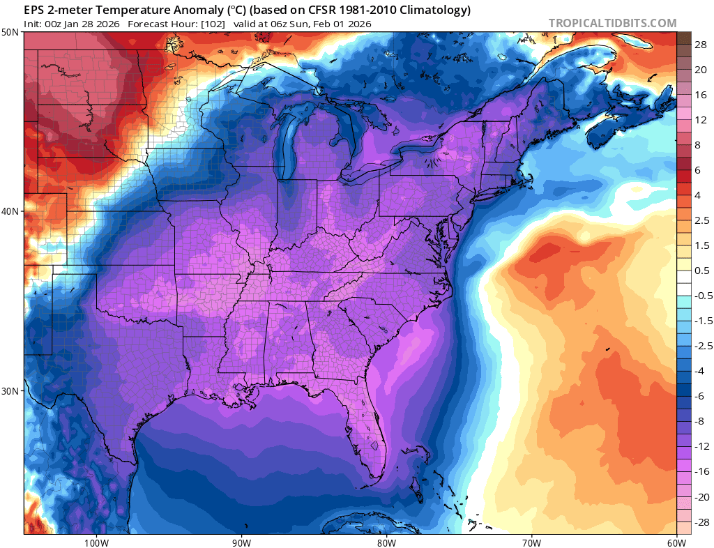
Arctic Hounds Unleashed: Long Duration Late January Cold Snap
Ginx snewx replied to WxWatcher007's topic in New England
This is Feb 15 like.thumb.png.cd9ddbd2e0fbf58c47a7ba9597e5329e.png)
-
Arctic Hounds Unleashed: Long Duration Late January Cold Snap
Ginx snewx replied to WxWatcher007's topic in New England
Agricultural nightmare. Frozen pipe city. Gonna need a lot of plumbers, fire sprinkler peeps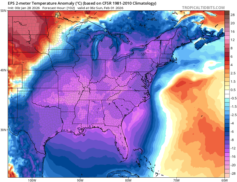
-
Post your February forecasts, due to storm situation will extend penalty free deadline to 06z FEB 2nd. I may change my mind but to start us off, -5.5 _ -6.0 _ -6.5 _ -6.5 _ -6.0 _ -5.0 _ +2.0 _ +2.0 _ +2.0
-

The “I bring the mojo” Jan 30-Feb 1 potential winter storm
StantonParkHoya replied to lilj4425's topic in Southeastern States
The SLP was actually East this run. It’s just doing ULL things in the foothills. . -

The Jan 31 Potential: Stormtracker Failure or 'Tracker Trouncing
Eskimo Joe replied to stormtracker's topic in Mid Atlantic
Deeper and further west. We're so close. -

The “I bring the mojo” Jan 30-Feb 1 potential winter storm
Coach McGuirk replied to lilj4425's topic in Southeastern States
-
Stick a fork in it?
-

The Jan 31 Potential: Stormtracker Failure or 'Tracker Trouncing
jayyy replied to stormtracker's topic in Mid Atlantic
Goal post will tighten later today - crazy thing is they are already very tight. Very minute changes are causing pretty large surface differences. H5 trended better across guidance today. We can only hope the surface follows suite tomorrow -
 SNOWCREATURE1 changed their profile photo
 -
Agreed - calling for a repeat of those storms is just a bit premature! The GFS vs. the world disconnect is really frustrating. Hoping for a consensus tomorrow.
-
Jeff Huffman @HuffmanHeadsUp Here are the top 15: 1. 20160123/1200 2. 20101226/1800 3. 19960108/0000 4. 20100303/0600 5. 19960216/1800 6. 20210202/0000 7. 19890224/0000 8. 19800303/0000 9. 20020103/1800 10. 20090120/1800 11. 20220129/0600 12. 20090302/0600 13. 20040310/1200 14. 19830311/1200 15. 19891224/0600 ------ FYI, he's with Baron Weather, a weather radar firm in Huntsville, Alabama.
-
The Jan 31 Potential: Stormtracker Failure or 'Tracker Trouncing
jayyy replied to stormtracker's topic in Mid Atlantic
It’ll be interesting to see how things look at 12z tomorrow as new data is ingested fully Certainly encouraging to see every model trend west up top at 0z. Perhaps the downstream impacts of that will show itself tomorrow and beyond. Perhaps it won’t.
.png.ba7864035d9935cd67a1571c025b406f.png)
.png.fdf1989b0888f85a87f2947a41135065.png)


.png.46e5475354b914d8022f67f41b0c84f7.png)