
All Activity
- Past hour
-

October Comes Early: Late September Multi-Hazard Hybrid Storm
dendrite replied to WxWatcher007's topic in New England
The Great Appalachian storm https://en.wikipedia.org/wiki/Great_Appalachian_Storm_of_1950 We were in the warm sector. That was a LLJ on roids…east flow and we were pulling near hurricane force sustained. Then the cold front went through from the south toward midnight…we had CAA from southerly flow, but the wind diminished behind the cold front. There was a point the next morning where it was snowing at BDR and raining at BDL. -

Strong Nor'Easter/Hybrid Storm Late September 2026
FPizz replied to Rjay's topic in New York City Metro
Good luck today -

Strong Nor'Easter/Hybrid Storm Late September 2026
MJO812 replied to Rjay's topic in New York City Metro
Sun trying to come out here -

October Comes Early: Late September Multi-Hazard Hybrid Storm
NeonPeon replied to WxWatcher007's topic in New England
This storm IS the monotony with kids at home and ceaseless drizzle. -

Strong Nor'Easter/Hybrid Storm Late September 2026
MANDA replied to Rjay's topic in New York City Metro
Lots of discussion over the last few days about how this storm should be classified. No shortage of opinions from several respected Mets. These two X posts make the most sense to me. It was shallow warm core and it did separate from fronts for a short time. No matter what it was not your typical cold season Nor-Easter and was not purely tropical. Hybrid or Sub-Tropical designation seems best way to go IMO.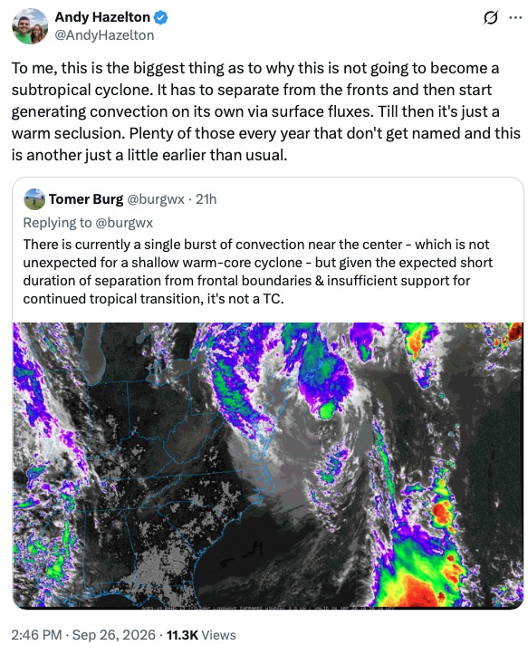
-
Probably at or over 0.5” for the weekend now?
-
I think this would be an unusual track for any time of the year! I can't recall a storm since Sandy that went retrograde.
-

Strong Nor'Easter/Hybrid Storm Late September 2026
uofmiami replied to Rjay's topic in New York City Metro
Post Sandy PSE&G has been more aggressive with cutting back trees from the lines, especially transmission lines. They also did a lot of FEMA money replacement projects of the transmission lines too. Perhaps it’s paying off or it’s just pure luck the outages weren’t worse. -

Strong Nor'Easter/Hybrid Storm Late September 2026
steve392 replied to Rjay's topic in New York City Metro
Minor flooding again from high tides on hackensack river. Up to 1.75" of rain so far. Coming down good again. Winds dying down a bit. -

October Comes Early: Late September Multi-Hazard Hybrid Storm
WinterWolf replied to WxWatcher007's topic in New England
That’s hilarious. -
.78 so far for the event... and another baseball rainout for us.
-

2026-2027 Record-breaking El Nino
Maestrobjwa replied to Stormchaserchuck1's topic in Weather Forecasting and Discussion
Next June? Dang does that usually happen? Thought there was mention of a rebound nina -
October Comes Early: Late September Multi-Hazard Hybrid Storm
WinterWolf replied to WxWatcher007's topic in New England
Was that a cane? Cuz those numbers are absolutely insane. Especially those inland numbers, holy smokes. -

October Comes Early: Late September Multi-Hazard Hybrid Storm
WxWatcher007 replied to WxWatcher007's topic in New England
-

Strong Nor'Easter/Hybrid Storm Late September 2026
straphanger replied to Rjay's topic in New York City Metro
1.85" of rain is my storm total so far, with 0.99" falling today alone. It was very gusty this morning with 47 MPH peak reported at LGA but it finally seems to be dying back now to something more manageable. Just waves of heavy drizzle and lighter rain moving through ever since this morning, even though the radar is struggling to depict that correctly. Seems to be lifting north of Queens though so hopefully we get into the afternoon break. -

October Comes Early: Late September Multi-Hazard Hybrid Storm
butterfish55 replied to WxWatcher007's topic in New England
Oh cool, it's pouring again. Can we double digit? -

Strong Nor'Easter/Hybrid Storm Late September 2026
Rjay replied to Rjay's topic in New York City Metro
A tree smashed my neighbor's roof -
 trusted canadian pharmacy or reputable canadian online pharmacy legitimate canadian online pharmacy http://www.city-fs.de/url?q=https://canamcrosscare.com top canadian pharmacy or https://virtualchemicalsales.ca/user/xhsiwmmntu/?um_action=edit canadian pharmacies online [url=http://images.google.mn/url?q=https://canamcrosscare.com]canadian pharmacy official website[/url] canadian pharmacies that deliver to the us or [url=http://www.sportchap.ru/user/tckvtrvzpe/]canadian drugstore online[/url] certified canadian pharmacy
 -
.thumb.gif.f92b16c631a1d15d405ed77b33f0710d.gif)
October Comes Early: Late September Multi-Hazard Hybrid Storm
Torch Tiger replied to WxWatcher007's topic in New England
I was just pointing out an extremely rare example of times winds can rival stronger TS's or canes.. BDR sustained 60mph in 1950 and 74mph in Gloria -

Strong Nor'Easter/Hybrid Storm Late September 2026
lee59 replied to Rjay's topic in New York City Metro
No power here -
yup... I wrote about this stuff in that interim storm/Oct thread but since it's a qualitative on the month overall I'm putting it here: Impressive +PNA index by October 10. Does the PNAP respond ...? In November I'd say we're looking at an early winter trigger with this... Mid October? not so sure. But it hearkens to mind an interesting aspect about our climate recency. Multi-source/ heavily agreed upon +3 SD index and it's showing up on the actualized ensemble mean synoptic layouts, as an unusually deep and pervasive negative anomaly axis N/NE of HA in the Pacific. It's also been been growing in coherence ... This strike me as a primitive telecon outlook/and attempt by the hemisphere to yet again ... snow in October. I gotta say... I saw it snow in October ..almost never in my first three decades living either in southern lower Michigan or SNE. Since ~ 2005? at least half the Octobers, particularly in the last 15 years, have hosted either a snow or a cryo-supporting atmosphere. Snowing in November has increased as well... though the startling earliness of Octobers - in no small part because it'll be snowing with still autumn foliage in the backdrops - is more impressive. 20 years worth ... let's see if we can add another October to the swelling sample size.
-

October Comes Early: Late September Multi-Hazard Hybrid Storm
Typhoon Tip replied to WxWatcher007's topic in New England
Impressive +PNA index by October 10. Does the PNAP respond ...? In November I'd say we're looking at an early winter trigger with this... Mid October? not so sure. Anyway, multi-source/ heavily agreed upon +3 SD and it's showing up on the actualized ensemble means as an unusually deep and convincingly spatially involving negative anomaly N/NE of HA in the Pacific. It's also been been growing in coherence ... probably should put this in the October thread. This strike me as a primitive telecon outlook/and attempt by the hemisphere to yet again ... snow in October. I gotta say... I saw it snow in October ..almost never in my first three decades living either in southern lower Michigan or SNE. Since ~ 2005? at least half the Octobers, particularly in the last 15 years, have hosted either a snow or a cryo-supporting atmosphere. Snowing in November has increased as well... though the startling nature of it is October - in no small part because it'll be snowing with still autumn foliage in the backdrops. 20 years worth ... let's see if we can add another October to the swelling sample size. -
Strong Nor'Easter/Hybrid Storm Late September 2026
MANDA replied to Rjay's topic in New York City Metro
Pretty cool radar evolution of this event from about 8pm last evening through current hour. Not your classic Nor-Easter look. https://weather.cod.edu/satrad/?parms=regional-eastcoast-comp_radar-200-1-100-1&checked=map&colorbar=undefined -

Strong Nor'Easter/Hybrid Storm Late September 2026
weatherpruf replied to Rjay's topic in New York City Metro
wife had a huntington's walk in nj canceled. no place to hide out here. -

October Comes Early: Late September Multi-Hazard Hybrid Storm
moneypitmike replied to WxWatcher007's topic in New England
Back into the rain following a short enough lull to get a quick walk. PWS in the 6.25 - 6.75 range.








