All Activity
- Past hour
-
Folks
-
out to 126...very encouraging so far
-
Positive signs thus far.
-
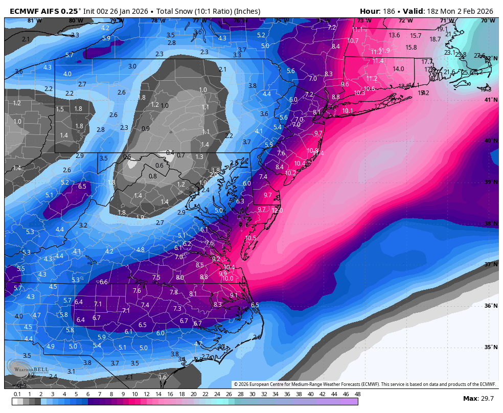
Boston wins again on 00z euro aifs
-
Euro AI
-
Shhh...dont wanna scare it away this time lol
-
 Pretty rare PWM has higher ratios than CON. 9.5"/0.68"
 -
Euro Ai OP rolling now .
-
did myself a favor and dug out the car tonight. tomorrow will probably look like some combination of Cool Runnings and Thunderdome in the parking lot
-
 Disappointment?
 -
05z PWM Obs 4.8" new / 9.5" total 0.35" SWE (0.68" total) Depth is 12".
-
 I think a swath of eastern MA won't have any break in the snow until the last of the coastal bands move offshore
 -
From Mike Masco.. respected TV met FWIW.. REPEAT PERFORMANCE NEXT WEEKEND?? I’ll say this — the EURO AI Ensembles have been doing an excellent job lately identifying early storm signals well ahead of time. And once again, I’m seeing some familiar ingredients showing up… • Ridging building over the West • Upstream blocking developing • A favorable 50–50 low setup • Storm track guidance beginning to align That combination holds some potential for maybe another next weekend storm! It’s early — and plenty can still change — but this is the type of large-scale pattern that supports repeat winter events in the Northeast. When the pattern starts whispering this loudly a week out, it’s worth paying attention. More on this tonight. See you at 10pm on PIX11 News
-
 What's your elevation? I'm on that little peninsula bounded by Sinking Creek. Pellissippi, and the TN river but at 980 feet elevation. I remember during my lurking years that my observations at my apartment in Hardin Valley were similar to yours with usually just a tick less snow, so I assumed you were maybe on a hill or in a slightly colder spot in that area
 -
We have 6 days to turn this into a perfect storm, slider, cutter, etc. Hopefully the Euro AI latches onto a favorable solution and stays there.
-
.thumb.png.4150b06c63a21f61052e47a612bf1818.png) Impact is the same 15" vs 20" the QPF was modeled well outside of a few NAM extremes.
Impact is the same 15" vs 20" the QPF was modeled well outside of a few NAM extremes. -

January 2026 regional war/obs/disco thread
vortex95 replied to Baroclinic Zone's topic in New England
At 150 hr, the GFS gets the 1000-500 thickness of 516 dm just into NE FL and the -5 C at 850 to MIA. That's Jan 1977 caliber stuff (snowed in MIA). -

January 2026 Medium/Long Range Discussion
NorthArlington101 replied to snowfan's topic in Mid Atlantic
Considering it didn’t really have a storm last run, this is an acceptable amount of progress. Would be a pretty annoying final outcome, though (not for our Eastern Shore folks though)
-
Short lived I'm sure but I am into a mid-level deform band that is just crushing right now.
-
 Very happy with the storm, but man 1.5"+ SWE and this cold, would have thought 20"+. Snow growth ftl
 -
yea bobby chill got 5" 10:1, nc/va border got 8" 10:1
-
January 2026 Medium/Long Range Discussion
NorthArlington101 replied to snowfan's topic in Mid Atlantic
I think it’s gonna go a little late for us. But much better and closer. -
 Haha 3.3”/0.39” in my last core That’s 8.9”/0.83” total so far Run of the mill SWFE up here. Maybe we can fluff it up today