All Activity
- Past hour
-
Sell 4 days of 60’s
-
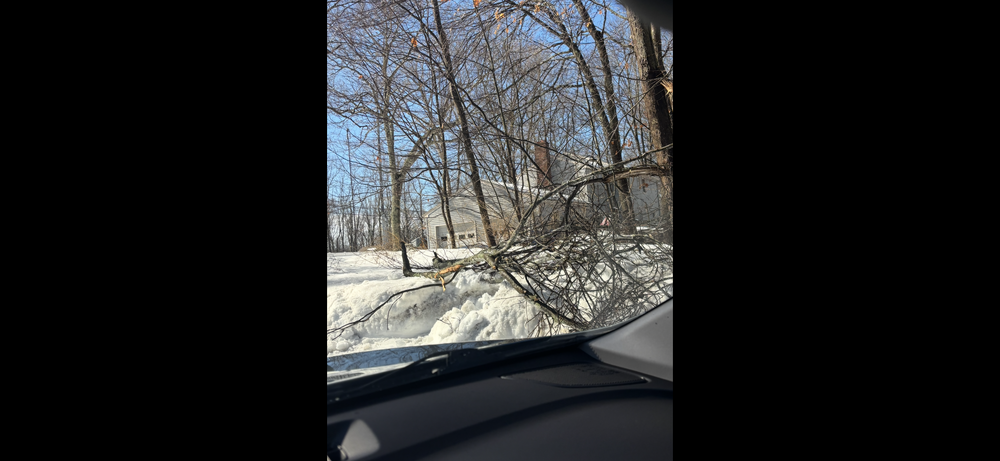
Yeah this won’t be a road issue south of 90. With 40’s today , near 40 tomorrow and near 30 tonight roads won’t be cold . Will be a tree issue and cold surface event. Hopefully more scenes like this in my street this morning .
-
I kinda feel like features are over amplifying in the daily guidance' for that range. But like you...unsure. I have objective reasons for thinking that though. 1 the models tend to be over amplification, always, in the D7 to ... Nth range. It's matter of how much, be it 44 or 4% but there seems to always be a time-dependent tax paid by the time whatever is being monitored is D5 <-- 2 can you think of a better month to f* up amplitude prospects in guidance (anyway), than a month where guidance' handling of ginormous +d(solar), and it's modulation impact, is suspect in perpetuity? Typically forced neutering of the patterns is more of an April phenomenon.. but there's likely to be some of that in March, particularly nearing and beyond the equinox. seems adding up those two inference techniques should constrain one's ideas - unless your IneedOlanzapine, who sees a blue contour over Baffin Island and throws a emoji at us like we're supposed arrest all actions and tune right in.. 3 is more of a super synoptic observation. It seems this trough and move toward +PNAP mid month is setting up a dreaded compression type. Normally I'd say that's an H.A. look there around the 15-17th ... in fact I think I mentioned that a couple days ago if mem serves. Any, I just see that trough in the ens means as setting a elephant's ass down on a trampolene, where the heights are bursting out both ends... That's means there huge velocity, which as we know...is really a destructive interference in principle. But here's the thing ... if 1 and 2 are right above, that means the trough might actually pass back through slow velocity, whereby S/W's can be conserved. So then we go the other way ... All and all? "unsure what mid month brings"
-
Verbatim, Colder? Yes. But an I-95 KU snowstorm pattern? I’m not so sure. Said it before, but come mid-late March, you want a stout west-based -NAO block/50-50 low and a stout -AO. You don’t have any of those….
-
Yesterday you were saying how very interesting it looked…damage you said…so now what changed for you?
-
Serious water in Mass in the snow. If that ripens too fast add another inch of w/e Friday then 60s for 4 days oh my
-
There is a half inch of solid ice on top of this. Can’t even break thru it
-
I am not going after you. I was stating for northern MD. It is a tight gradient. My son has a baseball scrimmage at Ripken Stadium. It would suck being 47 when 40 miles down the street it’s 77. This is just a perfect example of CAD. The Nam is a 20° difference between Baltimore and Washington DC
-
quite the cold drain on some of the mesos .. probably overdone but entertaining solutions
-
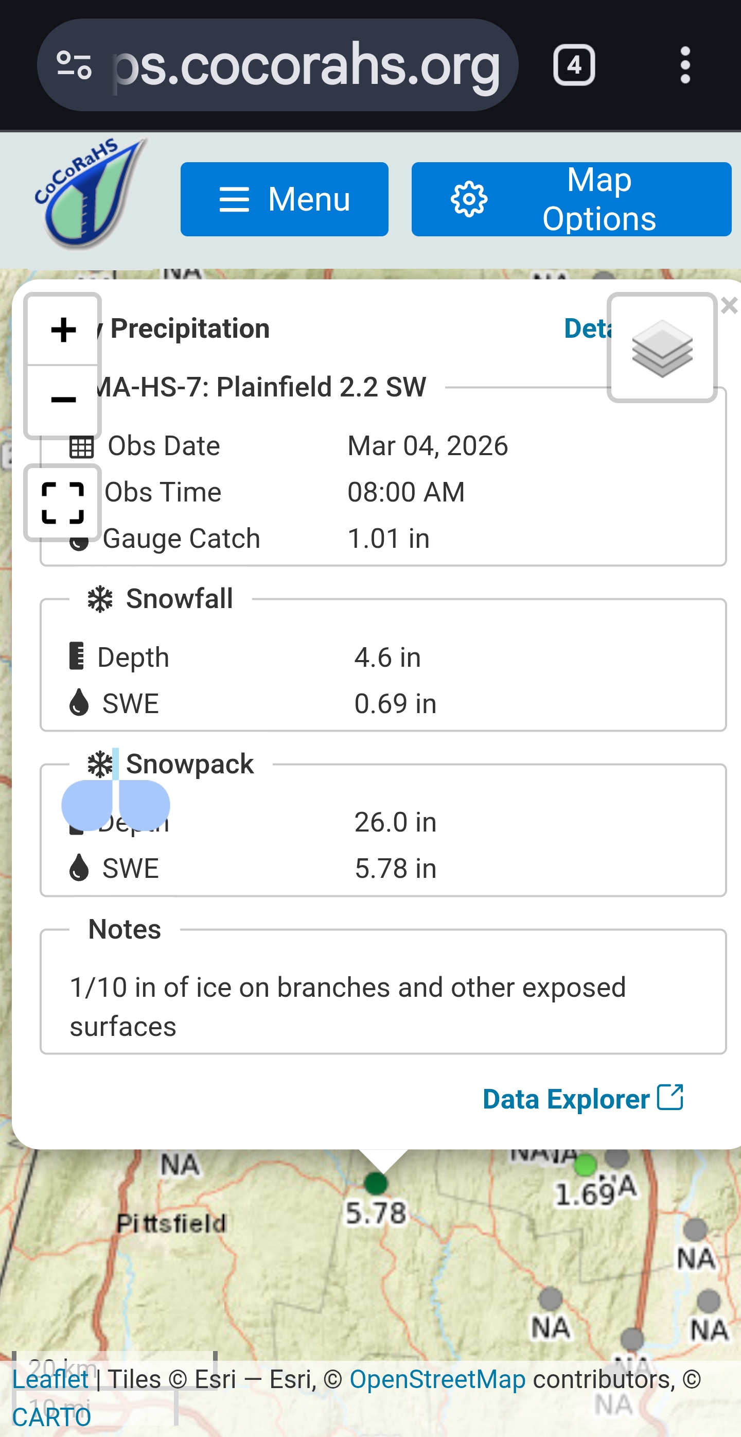
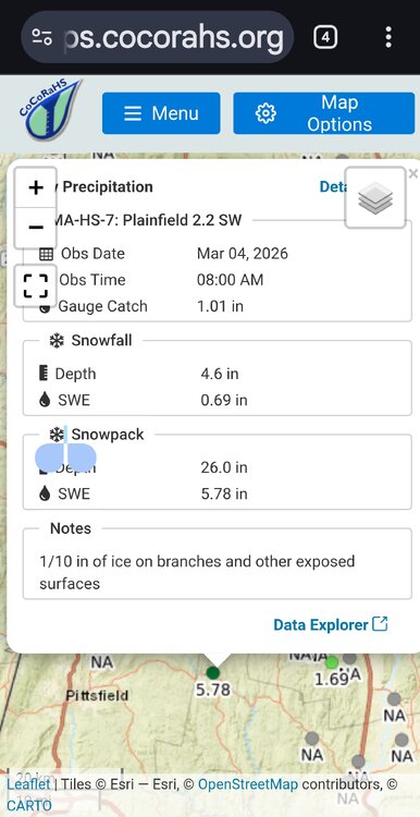
With ice on top. Just took my depth its at 15 average with 13 to 17. Woods are 21 to 25 in full shade.
-
March 4 1935: An extremely damaging ice storm hits Duluth. At the time it was called 'The worst ice storm in Duluth’s history'. The storm began with freezing rain and wet snow falling at the Duluth Weather Bureau at 7th Ave West and 8th Street at 10pm on March 3rd. The temperature was 26 degrees. By the morning of the 4th, the snow stopped but the freezing rain continued. The lights started going out in Duluth by 6pm on the 4th due to power lines breaking. By the morning of the 5th, Duluth was virtually isolated from the outside world except for shortwave radio. A local ham radio operator sent the Duluth National Weather Service reports: Four streetcars had to be abandoned in the storm, three of them in the western part of the city. A heavy salt mixture and pickaxes were used to try to free the stuck streetcars. A one-mile stretch of telephone poles along Thompson’s Hill was broken off as if they were toothpicks due to the ice. For Wednesday, March 4, 2026 1909 - Though fair weather was forecast, President Taft was inaugurated amidst a furious storm. About ten inches of wet snow disrupted travel and communications. The storm drew much criticism against the U.S. Weather Bureau. (David Ludlum) 1953 - Snow was reported on the island of Oahu in Hawaii. (The Weather Channel) 1966 - A severe blizzard raged across Minnesota and North Dakota. The blizzard lasted four days producing up to 35 inches of snow, and wind gusting to 100 mph produced snow drifts 30 to 40 feet high. Bismarck ND reported zero visibility for 11 hours. Traffic was paralyzed for three days. (2nd-5th) (The Weather Channel) 1987 - Rain and high winds prevailed in the northwestern U.S. A wind gust to 69 mph at Klamath Falls OR was their highest in 25 years, and winds at the Ashland Ranger Station in the Siskiyou Mountains of northern California reached 85 mph. (The National Weather Summary) (Storm Data) 1988 - Snow and freezing rain made travel hazardous in Ohio and Indiana. A six car pile-up resulted near Columbus OH, with seven injuries reported. Up to two inches of ice glazed central Indiana. Up to ten inches of snow blanketed northern Ohio. (The National Weather Summary) (Storm Data) 1989 - Thunderstorms produced severe weather in the Lower Mississippi Valley. A strong (F-3) tornado injured five persons near Brownsville MS, and killed seven cows and two hogs in one pasture. Thunderstorm winds gusted to 90 mph at Canton MS. (The National Weather Summary) (Storm Data) 1990 - A Pacific cold front working its way across the western U.S. produced heavy snow over parts of Idaho, Nevada and Utah. Up to eleven inches of snow blanketed the valleys of northwest Utah, while 12 to 25 inches fell across the mountains of northern Utah. Up to six inches of snow blanketed the valleys of east central Nevada, while more than a foot of snow was reported in the high elevations. In Idaho, 6 to 8 inches of snow was reported around Aberdeen and American Falls. (The National Weather Summary) (Storm Data) 2004 - An F0 tornado 2 miles north of Muldrow breaks a record stretch of days without a reported tornado, 292 days. 2008 - Only two days after reaching 78 degrees, St. Louis receives nearly a foot of snow in seven hours, the biggest snowstorm in 15 years.
-
wow heck of a melt going on today for everyone. Was this forecasted?
-
The real test is how long does the sun today take to melt off the 1.7" of snow from yesterday evening on top of existing snow.
-

-
Not sure why so many are honking there. It’s different now vs even a month ago. There is a push or colder air but it’s not like this is an arctic front coming through. Seems like any ice chances are best near Kevin on north. It’s possible it could extend south but with the warmth today seems like more your typical glaze on trees vs road?
-
Yes any absorptive surface is really going to melt with the sun. Going to take a while for the pure white areas to ripen with this ice layer
-
 Seems to be a shortage of topics for my area. We identify as western New England for the most part anyway. Looking forward to the pre-St. Patty's Day torch. M40s today, L50s this weekend, L60s through next hump day. BRING IT ON!!
 -
I understand with a frigid antecedent airmass and cold surface temperatures there is a risk for ice. What I don’t understand with some of the colder depictions of this upcoming event that I’ve seen this morning on local TV is how would that occur? The surface and air are torched with cold trying to drain in? Seems like too much warmth to overcome. Can anyone enlighten me on why they are honking for another ice event down here?
-
Yeah some mixed signals for me though. Anyways whatever, not worrying at this point. It is what it is.
-
Talking right now. When the dogs start falling thru rather than walking on then we melt. Half my driveway is still ice over snow. Still have some of that inch that fell the other day on paths.
-
If sunshine is maximized with no clouds —as it is today—it does a lot of damage to the pack.
-
Of course we are…it’s still 12 plus days away. When are we ever sure on a 12-14 day prog? But the signs are good…that’s all we need to see at this stage. Actually that depiction that Ginxy posted shows a decent ridge position on the 500mb look EPS…maybe we can get it to spike a bit more over the next 12 plus days…
-
39.1° and deep blues. Drip baby drip.
-
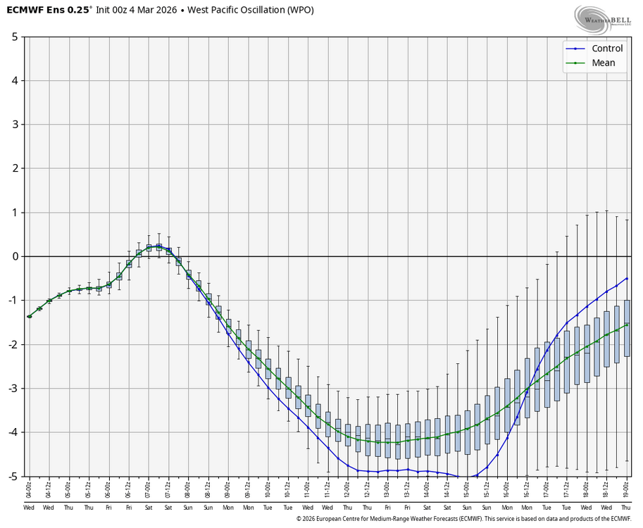
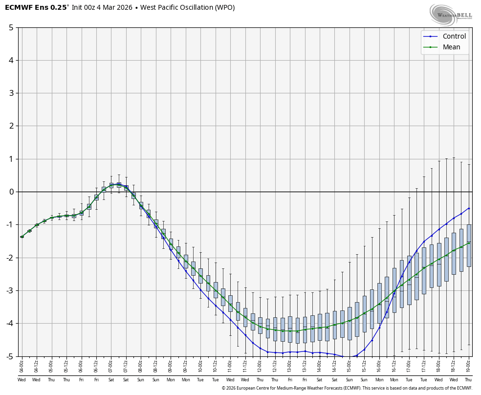
Upcoming -WPO punge, which wasn’t even on the models anywhere near to this extent just a few days ago, is progged to be the lowest in March since March of 2017, when there were hard freezes all the way down to N FL and snow in the Carolinas: