All Activity
- Past hour
-
Not backing off much at all really. The difference between a -3 to -4 from 2 to -3 in a long range forecast is pretty much statistical noise. The EPS is around a 0 to +1 the rest of the month. So that would yield a 7 station average of around -3 to -4 from the current -7.7. Long Island is running a little warmer and is only -5.5 at ISP.

-
Euro - within the last few days was also suggesting something similar but that negative NAO and the strength of it and the HP positionin southeast Canada could set up a gradient/overunning event somewhere in the Northeast and or Mid- Atlantic - example it might be in the 50's in Richmond and closer to 32 in NYC - we don't know yet
-

December 2025 regional war/obs/disco thread
Damage In Tolland replied to Torch Tiger's topic in New England
Riveting -
Flash freeze late Friday?
-

December 2025 regional war/obs/disco thread
weatherwiz replied to Torch Tiger's topic in New England
Thank God -

December 2025 regional war/obs/disco thread
SouthCoastMA replied to Torch Tiger's topic in New England
Yeah figured I'd bring that up since it was too positive around here. If we are to believe the machines -
Bottomed out at 23 last night. .
-
Torched to 43 yesterday. Lost 2” of snowdepth, now 7” at MSP.
-
I think a half inch or so is possible.. I guess we'll see
-
I mean if we keep shutting down climate studies, closing facilities (NCAR) and "burning" climate data, it obviously means it isn't real.....It happens all the time is the new response and will be backed up by the "new" data, complete with black sharpies that of course shows "it's all normal" But back to current discussion, hope it snows some time around Christmas, otherwise let it warm up so kids can play outside and travel isn't disrupted
-

December 2025 regional war/obs/disco thread
HoarfrostHubb replied to Torch Tiger's topic in New England
I don't think we see anything white out of Friday's event... maybe a few soggy flakes... but no accumulation -

December 2025 regional war/obs/disco thread
Ginx snewx replied to Torch Tiger's topic in New England
Your skinny ass does not have enough meat. -

2025-2026 ENSO
Stormchaserchuck1 replied to 40/70 Benchmark's topic in Weather Forecasting and Discussion
I did a statistic analysis once that had a 0.25 correlation to the pattern after 2007, a 0.30 correlation to the pattern after 2013, and a 0.40 correlation to the pattern 2019-2023. It dropped a little bit since 2023, but is still in the ~0.35 correlation range. Historically, the correlation as not as high but still there (0.05 to 0.10 before 2007) -
GFS is interesting for christmas eve and especially Christmas day!
-
Thanks, do we have statistics on how much the frequency has increased since 2007? Was there another "spike" in the past (if it was even tracked)?
-
Happened a few times here last year.. elevation FTW
-
December 2025 regional war/obs/disco thread
HoarfrostHubb replied to Torch Tiger's topic in New England
And no real cold following that... sometimes they get those rapid drops -
December 2025 regional war/obs/disco thread
weatherwiz replied to Torch Tiger's topic in New England
When I was walking out to the car this morning a massive owl flew overhead. Took me a second to realize what it was...thought it was a pterodactyl at first and was about to dive in a bush -

2025-2026 ENSO
donsutherland1 replied to 40/70 Benchmark's topic in Weather Forecasting and Discussion
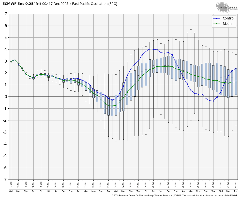
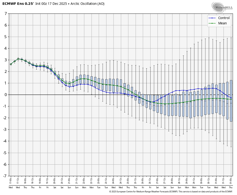
I may not have refreshed the chart from the EPO. When the NAO is negative, the pattern is cooler (36.4°). The larger idea that the Northeast will likely avoid a "torch" pattern through December still holds in either case. It's uncertain whether the warmth will break through to start January, but that's still far in the extended future. -
Thanks so this shows a positive PNA/east based EPO with an east based NAO which historically would have always worked and not linked up with a ridge. Goes to show the importance of the PNA region which is flipped now. I bet think "linking" always occured.
-
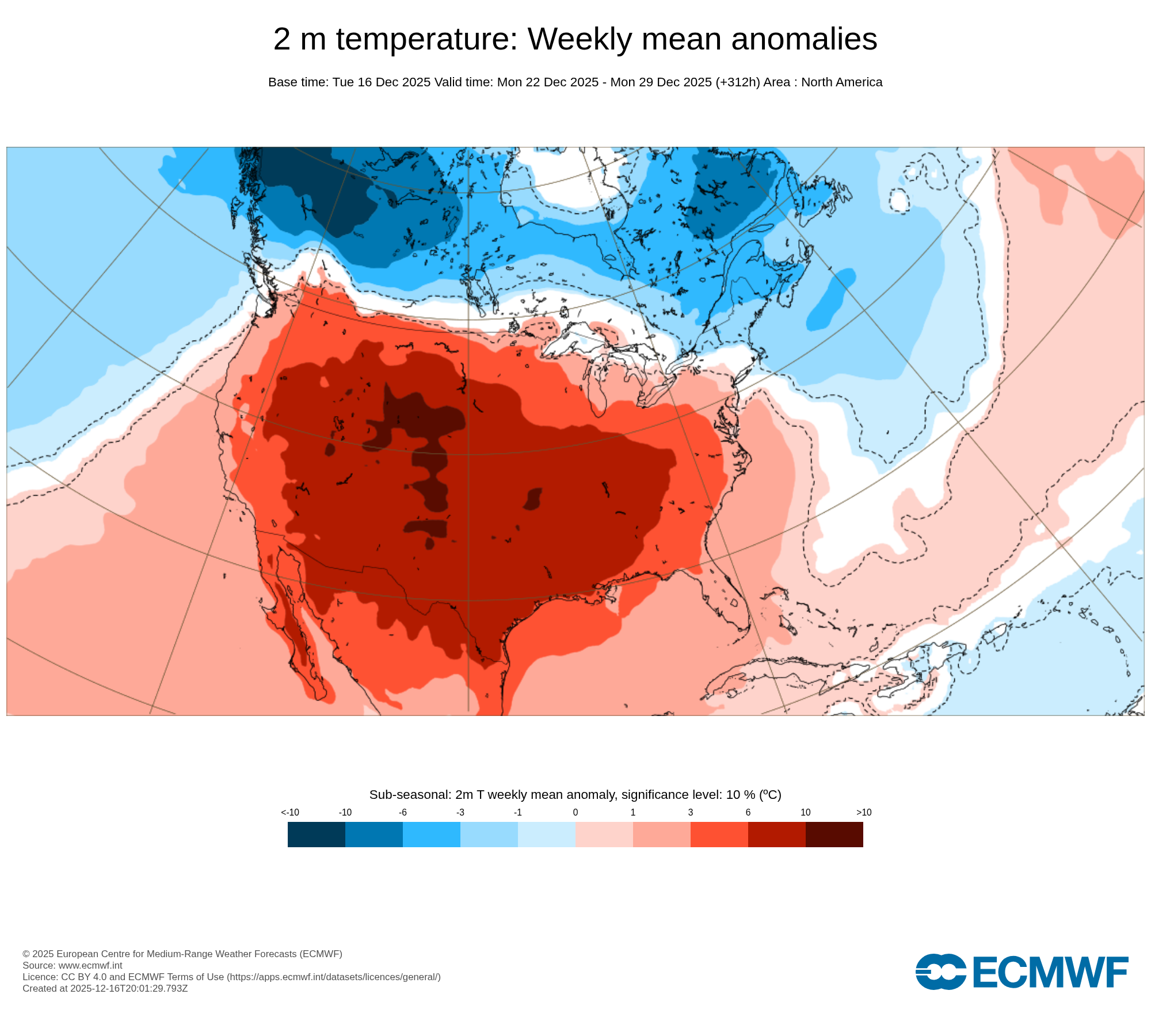
Yeah that ridge axis kept trending west. Congrats to the central US while we keep getting knifed with shots of cold.
-
Brief dip in EPO next week and AO trending down too on WB 0Z EPS...

-
December 2025 regional war/obs/disco thread
weatherwiz replied to Torch Tiger's topic in New England
Stagnant air too. Air Quality alerts for all the weed smoke hanging at ground level? -
if its marginal around here, I think we all know which direction this is going......
-
Imagine Christmas on the front range eating outside with windows open. Totally normal.