All Activity
- Past hour
-
Ordered some of this today. It gets good reviews. If it works I'll let folks know. I have three nests I have to kill.

-
Little warmer and more snowy..at least for most of SNE.
-
 Two years in a row for some spots. Monthly Mean Avg Temperature for NEWARK LIBERTY INTL AP, NJ Click column heading to sort ascending, click again to sort descending. 2025 75.4 82.1 75.3 77.6 2024 77.5 81.3 77.0 78.6 Monthly Mean Avg Temperature for TRENTON-MERCER AIRPORT, NJ Click column heading to sort ascending, click again to sort descending. 2025 72.1 78.4 72.0 74.2 2024 74.2 79.0 73.8 75.7 Monthly Mean Avg Temperature for Allentown Area, PA (ThreadEx) Click column heading to sort ascending, click again to sort descending. 2025 71.4 77.3 71.1 73.3 2024 72.7 76.9 72.1 73.9 Monthly Mean Avg Temperature for ATLANTIC CITY INTL AP, NJ Click column heading to sort ascending, click again to sort descending. 2025 74.2 79.4 71.5 75.0 2024 75.3 78.1 75.0 76.1
 -
I‘m guessing that the unimpressiveness of the wave over W Africa, the one the lemon is addressing, is why the models have backed off so much since Mon, when all major ops other than the GFS had this develop into a TC in the E MDR near the CV Islands.
-

eastern Atlantic blob 0/20
Wannabehippie replied to BarryStantonGBP's topic in Tropical Headquarters
Satellite photo of Africa is unimpressive to me. Until you get way out by Sudan/South Sudan. -
This wave won’t be coming off Africa til sometime this weekend.
-

eastern Atlantic blob 0/20
BarryStantonGBP replied to BarryStantonGBP's topic in Tropical Headquarters
So you think it won’t form -
eastern Atlantic blob 0/20
Wannabehippie replied to BarryStantonGBP's topic in Tropical Headquarters
Too far south, and too much SAL. -
Notice how he doesn’t post the AIF’s
-
 Don't believe it's happened before at my station but August will wind up cooler mean temp than June.
 -
 That bulletin just gave me chills. So ominous.
 -

2025-2026 ENSO
michsnowfreak replied to 40/70 Benchmark's topic in Weather Forecasting and Discussion
I also have a feeling the trees are really going to start taking off with these cool nights. Its not at all uncommon to see some stressed color by now, but I've been noticing many trees starting to get some color the last few days. - Today
-
If you read the article you deduce that it’s good to be queen.
-
Low of 59 at 6:22. High of 84 at 4:14pm.
-
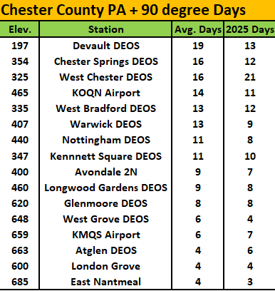
I suspect we are likely done with any more 90 plus days this year. Over at the PHL Airport they saw an above average of 36 such days.....here in Chester County a bit different story. We don't have our usual NWS COOP hot spots (Phoenixville and Spring City) reporting yet but below are current available stations with their 90+ days so far this year vs. each station's average number of such days.
-

E PA/NJ/DE Summer 2025 Obs/Discussion
ChescoWx replied to Hurricane Agnes's topic in Philadelphia Region
I suspect we are likely done with any more 90 plus days this year. Over at the PHL Airport they saw an above average of 36 such days.....here in Chester County a bit different story. We don't have our usual NWS COOP hot spots (Phoenixville and Spring City) reporting yet but below are current available stations with their 90+ days so far this year vs. each station's average number of such days.
-
Where did you see it? They're all around Worcester county now I guess.
-
This was all because I finally threw in the towel and reaped myself for the summer 2014 redux at the end of July. I’ll try pressing my luck and set up an auto-reap for this winter on November 1; that oughta lock us in an 09-10.
-
The 12Z GFS has this and makes it a H. The 12Z Euro has just a weak low. For the record: after 4 12Z JMA runs in a row with a TC from this, today’s 12Z JMA had no TC.
-
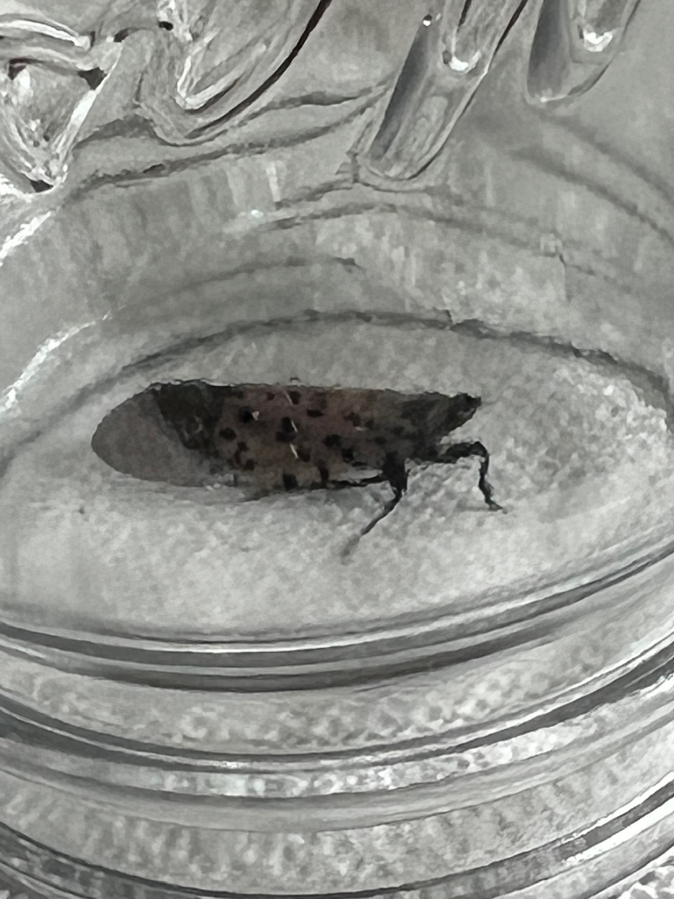
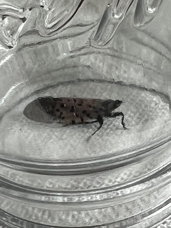
1st one I’ve ever seen locally.
-
Yeah I’m torn between viewing and trolling versus giving him the views and clicks. It’s a strange timeline that we live in.
-
 High temperatures will top out mainly in the upper 70s and lows will fall to lower 60s in New York City through tomorrow. Outside the City, lows in the 50s will be widespread. During the weekend, lows could fall into the 50s even in New York City. Highs will generally reach the middle and upper 70s. Dry conditions will persist into next week. A system could bring at least some rain during or after the middle of next week. The ENSO Region 1+2 anomaly was -0.1°C and the Region 3.4 anomaly was -0.4°C for the week centered around August 20. For the past six weeks, the ENSO Region 1+2 anomaly has averaged +0.45°C and the ENSO Region 3.4 anomaly has averaged -0.28°C. Neutral ENSO conditions will likely continue into early autumn. The SOI was +24.64 today. The preliminary Arctic Oscillation (AO) was +0.969 today. Based on sensitivity analysis applied to the latest guidance, there is an implied near 100% probability that New York City will have a cooler than normal August (1991-2020 normal). August will likely finish with a mean temperature near 73.6° (2.5° below normal). That would make August 2005 the coolest August since 2000. Supplemental Information: The projected mean would be 1.6° below the 1981-2010 normal monthly value.
 -

Mid to long range discussion- 2025
WinstonSalemArlington replied to wncsnow's topic in Southeastern States
Capital Weather Gang declares summer is over. Premature? https://www.washingtonpost.com/weather/2025/08/28/dc-early-fall-summer-over/ -
2025 Atlantic Hurricane Season
BarryStantonGBP replied to BarryStantonGBP's topic in Tropical Headquarters
Hi Lazza! Guess this means the wave off Africa probably might fizzle out and not develop no?