All Activity
- Past hour
-
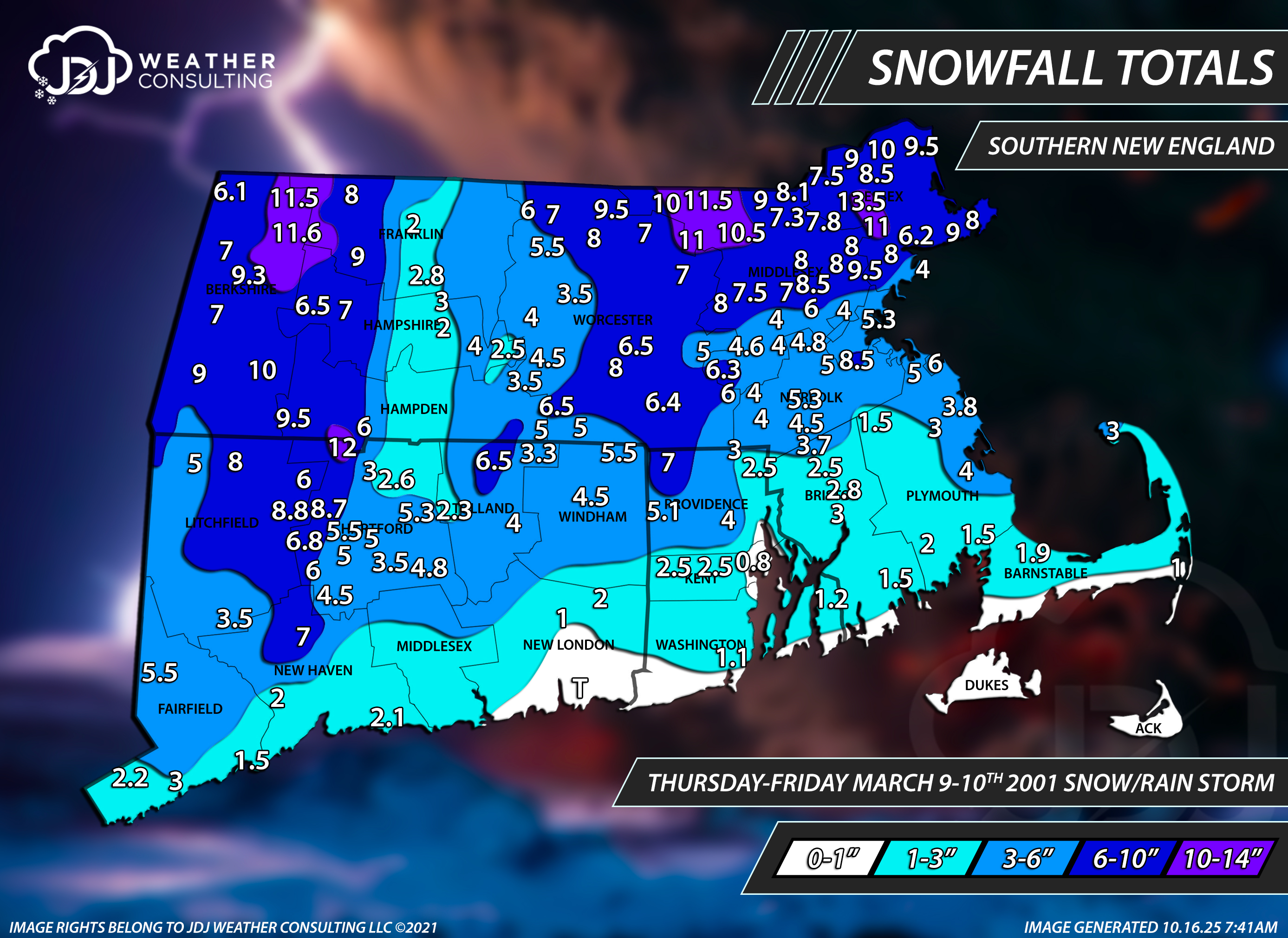
Yeah imagine that falling on top of the snow in those pics I posted above. It’s why I still have March 2001 as the king of snow pack in all my winters. Feb 2015 was super impressive but it did not have the amount of water the 2001 pack had at its peak.
-
So looking at my rainfall data so far. Event, so rain from that line is 0.69” Day is at 0.71” Week 1.25”. and so far for the month is 3.69”.
-
Ray may get 2” with rain here. Shoukd Niki his grade from B+ to A
-
Heavier echoes about to move in. See if it flips within the hour.
-
Scalping sleet in Greenfield. Slippery 32°
-
34 and rain. How pleasant.
-
He also authored the original Wintertime Instability Index (WINDEX) paper. Dude’s def a winter weather legend in the field
-
Possible many areas don’t get below freezing in March this year which is insane
-
Not questioning his meteorological skill, just his vibe
-
You guys are prob good for at least solid advisory. If you can flip to 100% snow sooner rather than later, could be a higher surprise.
-
Going to go with “unknown precip” at 3z as I head to bed.
-
Road is covered here as well but I think it's just an icy sleet coating. Don't think we've started mixing with flakes yet.
-
79.2 here today
-
-
Same here. Maybe some lower level stuff but alot of snow now and decent flakes.
-
This turned into a really nice soaker here. Sitting at just under an inch, and there's still some serious moisture headed towards us.
-
Kinda looks like the sleet line is headed northeast again on CC? Heavy sleet in my part of MHT.
-
The t-storm dropped about .6". Lots of lightning. Good downpour. That was summer-level.
-
.76 so far. Easily will be over an inch. Putting a good dent in the drought this week
-
Everything is covered....all pavement.
-
https://www.jdjweatherconsulting.com/mar-9-10-2001

-
You might want to skip the bruins on DVR.
-
Snow/sleet 50/50 mix...viz dropped. 32.2/31.8
-
3k backed off on the wedge Saturday
-
Pouring


.thumb.png.4150b06c63a21f61052e47a612bf1818.png)