All Activity
- Past hour
-

July 2025 Discussion-OBS - seasonable summer variability
SACRUS replied to wdrag's topic in New York City Metro
Records: Highs: EWR: 101 (1949) NYC: 99 (1949) LGA: 97 (1949) JFK: 98 (1949) Lows: EWR: 58 (1962) NYC: 57 (1903) LGA: 62 (1984) JFK: 61 (1965) Historical: 1898 - The temperature at Prineville, OR, soared to 119 degrees to establish a state record, which was tied on the 10th of August at Pendleton. (The Weather Channel) 1905 - Heavy rain in southwestern Connecticut caused a dam break, and the resulting flood caused a quarter of a million dollars damage at Bridgeport. As much as eleven inches of rain fell prior to the flood. (David Ludlum) 1916: Temperatures soared to record highs as a ten day heat wave reached its peak. The 102° at Lansing, MI tied the record for the hottest day ever there. Grand Rapids hit 103 °F as part of a record string of four consecutive days of 100 degrees or higher. Even the Lake Michigan shore was baking, with Muskegon hitting 95°. (Ref. Wilson Wx. History) 1930: The temperature at Holly Springs, Mississippi climbed to 115 °F to establish a new maximum temperature record for Mississippi. (Ref. Lowest and Highest Temperatures for the 50 States) 1958: The U.S. Congress passes legislation establishing the National Aeronautics and Space Administration (NASA), a civilian agency responsible for coordinating America’s activities in space. 1960: Severe thunderstorms brought damaging winds, possibly as high as 100 mph to central Oklahoma. Eight planes and several hangars were damaged at Wiley Post Airfield, while two aircraft and additional hangars were damaged at Will Rogers World Airport. The winds caused seven injuries in the area, including two youths who were injured by flying debris. 1971: An unseasonably chilly air mass invaded the upper Plains and Rockies. Sheridan, WY dropped to 35°, their record lowest July temperature. Other record lows included: Rapid City, SD: 41°, Huron, SD: 42°, Valentine, NE: 42°, Billings, MT: 43°, Cheyenne, WY: 43 °F. (Ref. Additional Temperatures Listed On This Link) 1974: Westchester County, NY -- Lightning associated with a brief afternoon thunderstorm killed one golfer. (Ref. Lightning-The Underrated Killer.pdf) 1979: Hollywood, MD was drenched by a 4 inch rain in 30 minutes. 1980: Early morning thunderstorms dropped 3.53 inches of rain at Philadelphia, PA, with most between 3 AM and 6 AM, setting a daily record and resulting in considerable roadway flooding.(Ref. Wilson Wx. History) 1981 - Fifty cattle, each weighing 800 pounds, were killed by lightning near Vance, AL. The lightning struck a tree and then spread along the ground killing the cattle. (The Weather Channel) 1986: Lightning struck and injured a man while he was installing drywall in his home at Berne, NY. This was the 4th time he had been hit by lightning since 1977. Intense thunderstorms over Rhode Island dumped 5.58 inches of rain and hail over a half inch in diameter at the airport in Providence. 6.26 inches of rain fell at Point Judith while Narragansett recorded 6.03 inches of rain and hail accumulated to a depth of close to 4 inches. (Ref. Wilson Wx. History) 1987 - Thunderstorms produced severe weather from Minnesota to Indiana and Illinois. A thunderstorm at Janesville, WI, produced wind gusts to 104 mph which flipped over two airplanes, and blew another plane 300 feet down the runway. The northeastern U.S. experienced some relief from the heat. Nine cities reported record low temperatures for the date, including Saint Johnsbury, VT, with a reading of 42 degrees. Barnet, VT, reported a morning low of 33 degrees, with frost reported on vegetation. (Storm Data) (The National Weather Summary) 1988 - Afternoon and evening thunderstorms produced severe weather in Minnesota and Wisconsin. Hail three inches in diameter was reported south of Saint Cloud, MN. Hot weather prevailed in the western U.S. Fresno, CA reported a record thirteen straight days of 100 degree heat. (Storm Data) (The National Weather Summary) 1989 - Morning thunderstorms in the Upper Midwest produced more than five inches of rain west of Virgil, SD. Afternoon and evening thunderstorms deluged the foothills and adjacent plains of Colorado with heavy rain. Rains of six to seven and a half inches fell in eight hours north of Greeley. Hail and heavy rain caused several million dollars damage in Weld County. (Storm Data) (The National Weather Summary) 2004: A record-setting flash flood occurred over part of the Greenville, South Carolina, during the morning hours. Six to eight inches of rain fell just east of Berea, a northwestern suburb, which caused the Reedy River through downtown Greenville crested 9 feet above flood stage. This crest was the highest level since 1908. 1996: A woman was killed while attempting to cross a low water bridge over Haw Creek in her vehicle in Morgan County, Missouri after thunderstorms dropped heavy rain causing flash flooding to occur. (Ref. Wilson Wx. History) 1999: Chicago, IL recorded its highest ever dew point temperatures 82° overnight on this date. (Ref. Wilson Wx. History) 2002: A two year old boy picking vegetables with his parents in Blount County, Alabama was struck by lightning. The family called 911 immediately, but put the child in an automobile and started for the hospital. Paramedics caught up with the family and began CPR. An Evac helicopter was called to transport the child to the hospital, but the little boy was dead on arrival. The important thing to remember is that many lightning victims simply stop breathing. Administering CPR immediately will often resuscitate a lightning victim. (Ref. Wilson Wx. History) 2004: A record setting flash flood occurred over part of the Greenville, SC, during the morning hours. Six to eight inches of rain fell just east of Berea, a northwestern suburb, which caused the Reedy River through downtown Greenville to crest 9 feet above flood stage. This was the highest level since 1908. A 112 year-old record was broken for the coolest high temperature in Oklahoma City, OK for September. The temperature only rose to 73°, which broke the previous record by 3 degrees. (Ref. Wilson Wx. History) 2008: Scattered afternoon storms developed over mainly south and southeastern portions of the Arkansas, Louisiana and Mississippi region, a few of which became severe and produced some hail and wind damage. One cluster of storms lingered over northern Forrest County, Mississippi and caused flash flooding around Hattiesburg with rainfall rates of 3 to 4 inches per hour. (Ref. Wilson Wx. History) 2009: The peak of a heat wave occurred today in WA State as all-time records were set at Bellingham (96), Sea-Tac Airport (103 °F -old record of 100 °F), Olympia (104 °F), and the National Weather Service Forecast Office at Sand Point-Seattle (105 °F). (Weather Guide Calendar with Phenomenal Weather Events 2011 Accord Pub. 2010, USA) 2010: The Richmond International Airport had a maximum temperature today of 101 °F that makes the ten day in 2010 with the temperature of 100 °F or more; the old record is nine set in 1954.(Ref. Richmond Weather Records - KRIC) 2011: Record Wettest July set at Chicago O'Hare- Another 1.40 inches of rainfall fell at Chicago-Ohare Airport Thursday 28th into Friday 29th morning...which brings the monthly rainfall total for July 2011 to 11.15 inches as of 7 am CDT. This sets a new record for the wettest July in recorded history in Chicago. The previous record was 9.56 inches in July of 1889. This also moves July 2011 up to the 7th wettest month ever in Chicago. In addition the all time record wettest month was August 1987 when 17.10 inches of rainfall was observed. (Ref. Chicago NWS ) -

July 2025 Discussion-OBS - seasonable summer variability
bluewave replied to wdrag's topic in New York City Metro
I get that sometimes here along the LI Sound when there is an inversion with the wetlands nearby. -

July 2025 Obs/Disco ... possible historic month for heat
tamarack replied to Typhoon Tip's topic in New England
June-July rain so far is 3.94". Driest June-July 1998-2024 here was 5.02" in 2004. I think that mark is toast. -
Was actually fairly pleasant (or not unpleasant) outside early this morning. 72 for the low. Already much less pleasant now . . . 81/76.
-
Not politics as both parties have cost our nation and it's taxpayers way too much for programs and studies that will not reduce or increase our temps by even 0.5 degrees.
-
Thanks for this. I’m already sweaty today.
-
As I mentioned yesterday some of our higher spots across the County had the potential not to reach 90 degrees on Monday and indeed 7 of the stations failed to reach there. So for those spots they will not "enjoy" their 2nd "heat wave" of the summer. For everybody else today will be day 2 and tomorrow day 3 but the final day of the "heat wave". We could see some heavy rain by later Thursday with a strong cold frontal passage. This will usher in well below normal temperatures for the weekend with an almost autumnal feeling as highs are in the 70's and nights in the 50's.

-

July 2025 Discussion-OBS - seasonable summer variability
Sundog replied to wdrag's topic in New York City Metro
But look how high quality it is! High frame rate and resolution, at least that's how it's perceived. And it's like 12 seconds long! I take a screenshot and the image is more than the 1.9mb limit. Good luck reducing the file size on a phone. -

E PA/NJ/DE Summer 2025 Obs/Discussion
ChescoWx replied to Hurricane Agnes's topic in Philadelphia Region
As I mentioned yesterday some of our higher spots across the County had the potential not to reach 90 degrees on Monday and indeed 7 of the stations failed to reach there. So for those spots they will not "enjoy" their 2nd "heat wave" of the summer. For everybody else today will be day 2 and tomorrow day 3 but the final day of the "heat wave". We could see some heavy rain by later Thursday with a strong cold frontal passage. This will usher in well below normal temperatures for the weekend with an almost autumnal feeling as highs are in the 70's and nights in the 50's.
-
July 2025 Discussion-OBS - seasonable summer variability
SACRUS replied to wdrag's topic in New York City Metro
84 / 72 , partly cloudy. Heat is on - clouds in PA may mov through between 9:30 - 11:30 otherwise sunny hot. Mid - upper 90s, enough sun the hot areas to 100. More of the same tomorrow ahead of the front. Front timing and clouds the caveat to Thursday getting to 90. Storms still look to drop loads of rain where they setup Thu / Fri with slow moving boundary and ridge not budging. Cooler east / northeast regime Sat - Tue /Wed next week . Ridge west building erast, Atlantic ridge keeping the coast in higher heights with more southerly flow and a warm - hot and humid return towards the 8th. Looks to be warm - hot / wetter beyond. 7/29 - 7/31 : Hot / humid - storms focussed Thu PM 8/1 : Hung up boundary could be storms / wet 8/2 - 8/8 :; Cooler - East/Northeast flow - limited 90s if any at all (inland) 8/8 - beyond : Warm - hot / humid wetter overall -

July 2025 Obs/Disco ... possible historic month for heat
dendrite replied to Typhoon Tip's topic in New England
Looks wetter up here lol At least on mesos -

Occasional Thoughts on Climate Change
Typhoon Tip replied to donsutherland1's topic in Climate Change
Should be put on the mileXmile sized headstone over humanity's grave ... along with all the other dark ironies that fucking made it happen -
Work in renewables and can confirm that this is the case. The 2025 numbers are even more compelling. For example, the average cost of an energy storage system dropped about 27% in the past year due to technology improvements (and a reduction in EV demand, unfortunately). Currently, battery systems are competitive with LNG Peaker plans in MISO (Midwest) where fossils were heavy entrenched incumbents. The reality is that PV + BESS make so much sense. The technology pair has no long-term extraction costs, can be recycled, and of course, no long-term combustion impacts. BESS is also the "swiss army knife" of grid technology and can respond to grid disturbances in milliseconds. Peaker plants, or even nuclear, can't do that. The problem is adoption still isn't happening fast enough. This should have been 10 years ago.
-

2025 Atlantic Hurricane Season
BarryStantonGBP replied to BarryStantonGBP's topic in Tropical Headquarters
tutt 2025-2025 lest we forget -

July 2025 Discussion-OBS - seasonable summer variability
Nibor replied to wdrag's topic in New York City Metro
Technically it’s a gif -
July 2025 Discussion-OBS - seasonable summer variability
Sundog replied to wdrag's topic in New York City Metro
There is a rare smell of tow tide here. Not helping with the extra heat and humidity this morning. -
Central & Eastern Pacific Thread
BarryStantonGBP replied to Windspeed's topic in Tropical Headquarters
Central North Pacific (140°W to 180°) Tropical Weather Outlook (en Español*) 200 AM HST Tue Jul 29 2025 Hurricane Iona Satellite | Buoys | Grids | Storm Archive ...IONA STRENGTHENS INTO A MAJOR HURRICANE FAR SOUTH-SOUTHEAST OF THE HAWAIIAN ISLANDS... 11:00 PM HST Mon Jul 28 Location: 10.8°N 153.2°W Moving: W at 13 mph Min pressure: 964 mb Max sustained: 115 mph Public Advisory #9 1100 PM HST Forecast Advisory #9 0900 UTC Forecast Discussion #9 1100 PM HST Wind Speed Probabilities #9 0900 UTC Wind Speed Probabilities Arrival Time of Winds Wind History Warnings/Cone Interactive Map Warnings/Cone Static Images Warnings and Surface Wind Tropical Storm Keli Satellite | Buoys | Grids | Storm Archive ...KELI MOVING WESTWARD... 11:00 PM HST Mon Jul 28 Location: 12.5°N 146.6°W Moving: W at 12 mph Min pressure: 1006 mb Max sustained: 40 mph Public Advisory #4 1100 PM HST Forecast Advisory #4 0900 UTC Forecast Discussion #4 1100 PM HST Wind Speed Probabilities #4 0900 UTC Wind Speed Probabilities Arrival Time of Winds Wind History Warnings/Cone Interactive Map Warnings/Cone Static Images Warnings and Surface Wind -

2025 Lawns & Gardens Thread. Making Lawns Great Again
Chrisrotary12 replied to Damage In Tolland's topic in New England
My grass is so dead. -

2025-2026 ENSO
40/70 Benchmark replied to 40/70 Benchmark's topic in Weather Forecasting and Discussion
Yes, understood with respect to where the correction vector was in the medium range and on a seasonal level in non-mismatch years. -
88/76 at 8a is just cruel. I’m completely drenched waiting for the bus to the office.
-

July 2025 Obs/Disco ... possible historic month for heat
Damage In Tolland replied to Typhoon Tip's topic in New England
South trend -

July 2025 Obs/Disco ... possible historic month for heat
weatherwiz replied to Typhoon Tip's topic in New England
Absolutely beautiful outside. Already feel the process of my body beginning to produce sweat. There is nothing like feeling the hot, strong sun beat down on you and the tingles you get when the sweat producing process commences. I mean this is gold, everyone loves it. The birds are happy, praying mantis are happy, people have smiles on their faces. Feel it, embrace it, love it. -
July 2025 Obs/Disco ... possible historic month for heat
Typhoon Tip replied to Typhoon Tip's topic in New England
Looked to me like the whole blend bumped S a little bit. That may not be caused by repositioning the track of that frontal mess, per se. It could also be an artifact of that amplitude flattening - a problem we've discussed ad nauseam in the past, where the models sometimes have trouble maintaining mid/ext outlook amplitude when relaying into short ranges. Hard to tell precisely, as this scenario with rain/amts on Thur/Fri looks pretty sensitive to very subtle physical perturbation, anyway, so - I just see the 00z UKMET type solution as not impossible at least in principle. It may be overdoing that suppression some sure. -
The GFS and Euro doesn't have us above 90 again after Thursday until August 10th. I'd count that as a win.
-
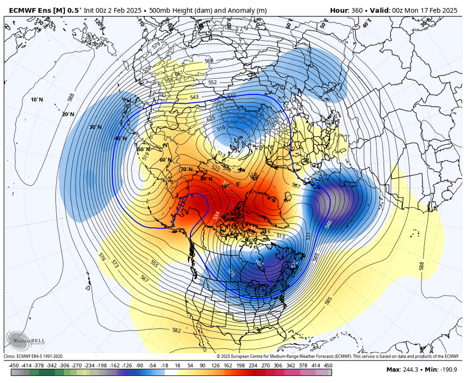
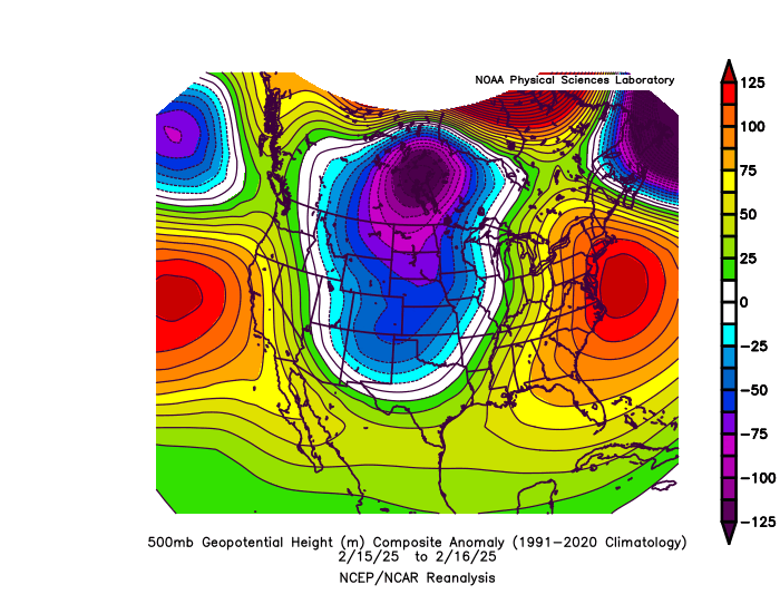
The ECMWF seasonal forecast system from before the winter missed the +PNA mismatch that I was discussing the potential for last October with the early MJO indicator. So the long range forecasts from months like October were obviously too warm since it missed the correct 500mb pattern. But in previous years without a mismatch, the seasonal model was too cold from October for the 22-23 and 23-24 winter forecasts. It missed the record warmth both winters from the fall seasonal forecasts. Now the 2nd way the Euro was incorrect last winter involved the medium term 15 day EPS. It was too cold overall in the Northeast but did better in other parts of the country. The 500 mb long range pattern forecast for February missed the Southeast Ridge linking up with the -5 AO in mid-February. It had a classic KU look around the time of the big -AO drop. We wound up with the storm cutting west of the big cities leading to the record snows in Toronto and Montreal. In the past we didn’t get these Southeast Ridge linking ups with such strong blocking near -5 SD around Greenland. The model actually did a very good job at the higher latitudes. But missed the subtropical ridge amplification. This is why the heavy snows it had around NYC in the longer range forecasts wound up significantly further north. This has been the case since the 18-19 winter with the big snowstorm always being 8-15 days away. The GFS and CMC have had the same issue so not so not just singling the Euro out. But it’s the highest scoring model overall so it gets more attention. The charts below represent a repeating model error or bias since the 18-19 winter. EPS long range forecast had the classic KU look but missed the strong Southeast Ridge amplification leading to the first February cutter for a -5 -AO