All Activity
- Past hour
-
Saturday looks fine in CT and most C and W Mass clearing and mild mid morning on
-
Special Weather Statement National Weather Service New York NY 305 PM EDT Thu May 8 2025 NYZ067-081930- Orange NY- 305 PM EDT Thu May 8 2025 ...A STRONG THUNDERSTORM WILL IMPACT NORTHEASTERN ORANGE COUNTY THROUGH 330 PM EDT... At 303 PM EDT, trained weather spotters reported a strong thunderstorm producing pea size hail near New Windsor, or near Newburgh, moving northeast at 10 mph. HAZARD...Winds in excess of 30 mph and pea size hail. SOURCE...Trained weather spotters. IMPACT...Gusty winds could knock down tree limbs and blow around unsecured objects. Minor hail damage to outdoor objects is possible. Locations impacted include... Newburgh, New Windsor, Gardnertown, Orange Lake, Washingtonville, Firthcliffe, Vails Gate, Balmville, and Cornwall On Hudson.
-
Not feeling so good about the second half of May anymore
-
-
And Flood Watches have been hoisted.
-
It's faster going downhill. Day started with ~2 hours of PC, then the clouds closed back in with a few spritzes. At least it's low 60s.
-
@wdragI-84 watch dropped
-
Wantage NJ 8 s High Point. 0.41" 125P-2P in my stratus (0.45 on my AWN). So the .41 matches the OHP,THP,STP seen at 220PM this afternoon off DIX. No thread at this time... if NWS drops a watch on I84 I lmght add a thread...that seems where iso 4" reports should occur between today-12z Sat. Unlikely thread at this time.
-
wow Ocean County Airport-89- is that Toms River?
-
I remember this was the case in summer 1995, it's why the Mississippi River valley was so wet with the ring of fire surrounding us, August 1995 was historically dry because of it.
- Today
-
Yeah, the Southeast Ridge or WAR has been very strong this month. So the heaviest rains were pushed up further north than the I-78 to I-80 corridor. Looks like a repeat performance for the next few days.
-
Straight shot on 89 to 93. Draw a line from like BOS to Stowe and the interstates are pretty close to that. Takes me a solid 4 to get to your hood at the Woodstock/Southbridge line. Gotta go 89 to 91 down to Springfield at the Pike then over.
-
That's fine, but recent forecasts haven't really been reflective of that fact.
-
Been steady with that. Still some models differing, but should be another soaker.
-
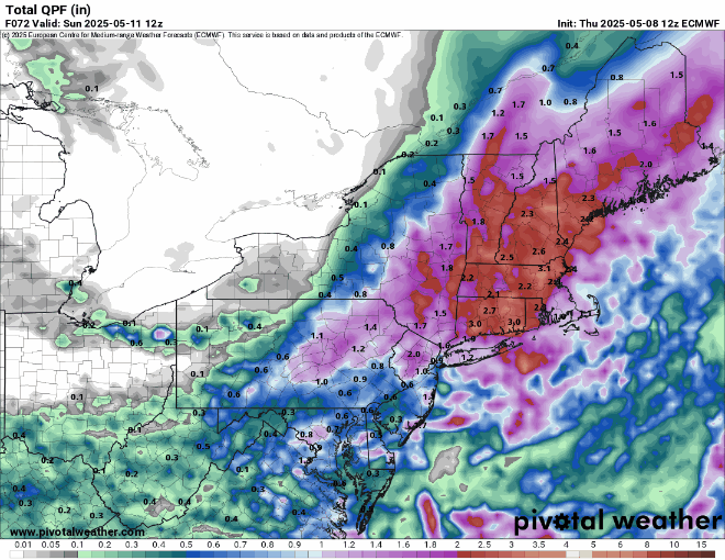
Euro is 2 to 3 for most except far eastern areas and the cape with showers into Saturday afternoon.. Sunday looks really good though
-
Made it to 80 ahead of the clouds now down to 77 / 55
-
Storms popping
-
The rain is thankfully. We mow we sun
-
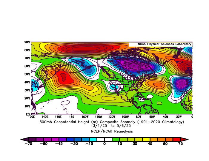
It already has. The very strong 500mb ridge has returned to the east of Japan and south of the Aleutians this spring. Also notice the Southeast Ridge or Western Atlantic Ridge linking up again with the Greenland to Iceland blocking.
-
Boundary a little further south than modeled?
-
His last name is Epstein. So Epstein then became Droughtstein....and then just Stein. He's an avid gardener and when rain doesn't happen he gets very very upset.
-
12 Euro an inch to an inch and a half for a lot of the area. Some other models are in the half inch to inch range. This event still looks like a half inch to inch for most of the area, with some spots maybe getting as much as an inch and a half.
-
The strong onshore flow kept the upper 80s heat to our West. for May 1, 2025 through May 7, 2025 Click column heading to sort ascending, click again to sort descending. OCEAN COUNTY AIRPORT WBAN 89 Newark Area ThreadEx 88 NEWARK LIBERTY INTL AP WBAN 88 HARRISON COOP 88 TETERBORO AIRPORT COOP 87 TETERBORO AIRPORT WBAN 87 ESTELL MANOR COOP 87 SOMERSET AIRPORT WBAN 86 PHILADELPHIA/MT. HOLLY WFO COOP 86 New Brunswick Area ThreadEx 86 HIGHTSTOWN 2 W COOP 86 NEW BRUNSWICK 3 SE COOP 86 CALDWELL ESSEX COUNTY AP WBAN 86 Atlantic City Area ThreadEx 85 PENNSAUKEN 1N COOP 85 MILLVILLE MUNICIPAL AIRPORT WBAN 85 ATLANTIC CITY INTL AP WBAN 85 MOORESTOWN 4 E COOP 85 FREEHOLD-MARLBORO COOP 85 EWING 3 WNW COOP 85 FLEMINGTON 5 NNW COOP 85 SOUTH JERSEY REGIONAL AIRPORT WBAN 85 Trenton Area ThreadEx 84 MARGATE COOP 84 MANASQUAN 1 NW COOP 84 LONG BRANCH-OAKHURST COOP 84 TRENTON-MERCER AIRPORT WBAN 84 SUSSEX AIRPORT WBAN 83 CHARLOTTEBURG RESERVOIR COOP 83 SCHOOLEY'S MOUNTAIN 1 SW COOP 81 BOONTON 1 SE COOP 81 HIGHLAND LAKES 1SW COOP 80 Data for May 1, 2025 through May 7, 2025 Click column heading to sort ascending, click again to sort descending. NJ NEWARK LIBERTY INTL AP WBAN 88 NJ HARRISON COOP 88 NY LAGUARDIA AIRPORT WBAN 87 NJ TETERBORO AIRPORT WBAN 87 NJ TETERBORO AIRPORT COOP 87 NJ CALDWELL ESSEX COUNTY AP WBAN 86 NY NY CITY CENTRAL PARK WBAN 85 NJ CHARLOTTEBURG RESERVOIR COOP 83 NY SHRUB OAK COOP 83 NY WESTCHESTER CO AP WBAN 83 NY PORT JERVIS COOP 82 NY MONTGOMERY ORANGE COUNTY AP WBAN 82 CT DANBURY MUNICIPAL AP WBAN 82 NY CENTERPORT COOP 82 NY PORT AUTH DOWNTN MANHATTAN WALL ST HEL ICAO 81 NY BAITING HOLLOW COOP 81 CT MERIDEN MARKHAM MUNICIPAL AP WBAN 81 CT OXFORD WATERBURY WBAN 79 NY SYOSSET COOP 79 CT NORWICH PUBLIC UTILITY PLANT COOP 79 NY RIVERHEAD RESEARCH FARM COOP 78 NY JFK INTERNATIONAL AIRPORT WBAN 77 NY ST. JAMES COOP 76 NY ISLIP-LI MACARTHUR AP WBAN 76 NY FARMINGDALE REPUBLIC AP WBAN 75 NY SHIRLEY BROOKHAVEN AIRPORT WBAN 75 NY UPTON COOP - NWSFO NEW YORK COOP 75 CT NEW HAVEN TWEED AP WBAN 74 CT IGOR I SIKORSKY MEMORIAL AIRPORT WBAN 73 CT GUILFORD COOP 73 NY ORIENT POINT STATE PARK COOP 72 NY BRIDGEHAMPTON COOP 71 CT DANBURY COOP 70 NY WESTHAMPTON GABRESKI AP WBAN 70
-
The way weekends have been going, I'm expecting much of Saturday to blow


