All Activity
- Past hour
-
CAM ON ERIN BAM BAM BAM Special Message from NHC Mon, 11 Aug 2025 14:10:30 +0000 NHC will initiate advisories on Tropical Storm Erin, located in the Eastern Tropical Atlantic, just west of the Cabo Verde Islands, at 1100 AM EDT (1500 UTC). SCORE SOME FAKKIN GOALS LASS
-
Getting crushed with heavy rain this morning. Over an inch already and lots more coming.
-
Not to nitpick but BOS was 84/64 yesterday which is exactly normal. Felt pretty hot once west of the city however at least my real feel.
-
1.5F below the record high daily mean, which was 83.5F set on June 19, 2024. Prior to that date, the record had been 82.5F.
-
It was 96 on June 19, 2020 & June 19, 2024. I missed the other 96F from 2020 because it only lists the most recent on the "calendar day summary." Interestingly, that same day (June 19) has matched the all-time record at CAR twice in the 2020s.
-
June 19, 2020 rather than last year. I chose that May day to add 6" of fiberglass insulation to the attic of our tiny (18x20) 2-story. Finished by 11 AM but it was already near 90 outside, 120+ in the workspace. Next day CAR had 95/69; that 82° mean is only 0.5° below their all time hottest.
-
 The haves and the have nots. When will this heat spill south and east out of northern New England and Upstate New York? It's like an impenetrable wall.
 -
AL, 05, 2025081112, , BEST, 0, 173N, 273W, 40, 1004, TS, 34, NEQ, 20, 0, 0, 30, 1010, 160, 20, 0, 0, L, 0, , 0, 0, ERIN, M, 0, , 0, 0, 0, 0, genesis-num, 016, TRANSITIONED, alA72025 to al052025 Looks like it got renumbered.
-
This may come as a shock to some people...but I just read that The Farmer's Almanac is calling for a long, cold and snowy winter!
-
We had a huge acorn drop overnight at the edge of our property. Very weird.
-
Good try, but you know he doesnt give 2 shits about being objective.
-
If you get back in a car thats been running, and look at the diggi thermo, it ususally is hotter than ambient temp. Go down the road 5 miles and its 5 degrees cooler.
-
I agree that the troughing in the western atlantic looks very unfavorable to an east coast hit, but the syntopic scale ridge out west is deamplifying, and sliding west, while the western atlantic ridge is building west. Both those trends are favorable to a close approach..
-
 It gets brought up multiple times per day, sometimes spanning over pages, since the board existed. Where have you been? It gets talked about more than anything else on this entire sub forum.
 -
yep, No complaints from this guy.
-
Leaves have that leathery look.
-
Yesterday was the 14th day at or above 90F at PIT this year. The point-click forecast suggests the possibility of as many as 4 more over the next week (forecast highs of 91 today, 90 tomorrow, 90 on Saturday & Sunday). Either way, should be a fairly warm to hot stretch which will likely eliminate the current monthly temperature deficiency.
-
yeah its gettin dry. Told yas the other week, all the "epic rain" chatter was being listened to by more than just AI. Mo nature heard us too and is doing what she does best, average things out.
-
Because its the outta forum troll that uses his bias to call out anything that doesnt fit his narrative.
-
The average high temperature at Buffalo has averaged 1.5F warmer than New York City (Central Park) for the first 10 days of August. Looking at historical records dating back to 1873 (153 years), I can find only 7 years where Buffalo was warmer for average high temperature for the first 10 days of August: 2025 (+1.5), 2021 (+2.5), 2016 (+3.4), 1959 (+1.8), 1947 (+5.9!), 1911 (+0.1), 1887 (+2.6). Based on 1991-2020 climate normals, Buffalo should be 4.5F cooler than New York City for mean high temperature over the first 10 days of August. The 153-year mean difference is slightly higher, with New York averaging 5.1F warmer. Oddly, over the last 10 years (2016-2025), the difference between the two locations has averaged only 2.0F, with 3 of the 7 cases noted above occurring in that 10-year stretch. Not sure if there's a problem with the sensor at Central Park, but certainly a strange discrepancy from the historical norms.
-
Maples are already fading up at the high elevations.
-
We should see for some spots today recording their first above normal temperature day so far here in August. The humidity will also increase. The warmest day of the work week should be tomorrow with temperatures well up into the 80's and maybe touching 90 degrees in some of the valley locations. A front should pass through the area on Wednesday night which should bring the humidity down toward the end of the week. We could see some showers and thunderstorms with the front by Wednesday evening. Next weekend looks sunny with increasingly warm temperatures.
-

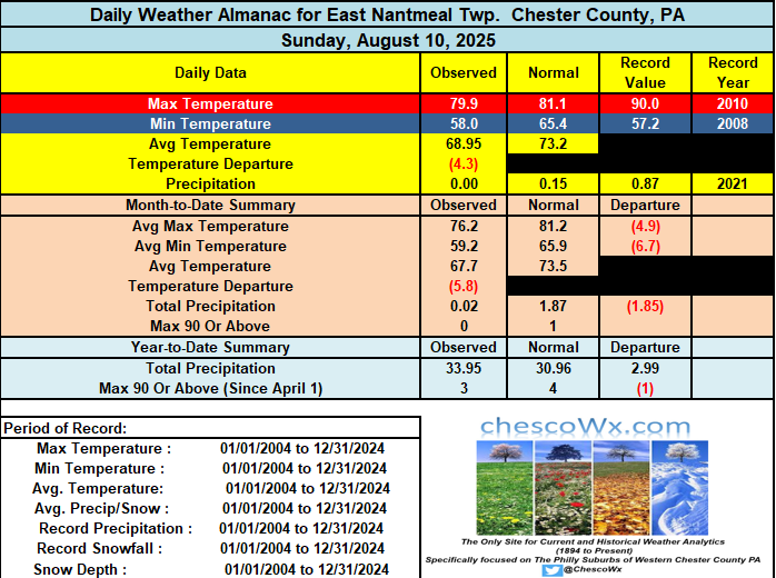
E PA/NJ/DE Summer 2025 Obs/Discussion
ChescoWx replied to Hurricane Agnes's topic in Philadelphia Region
We should see for some spots today recording their first above normal temperature day so far here in August. The humidity will also increase. The warmest day of the work week should be tomorrow with temperatures well up into the 80's and maybe touching 90 degrees in some of the valley locations. A front should pass through the area on Wednesday night which should bring the humidity down toward the end of the week. We could see some showers and thunderstorms with the front by Wednesday evening. Next weekend looks sunny with increasingly warm temperatures.


.thumb.png.4150b06c63a21f61052e47a612bf1818.png)
