All Activity
- Past hour
-
Don't be silly Ji doesn't understand geography
-

First Winter Storm to kickoff 2025-26 Winter season
CoastalWx replied to Baroclinic Zone's topic in New England
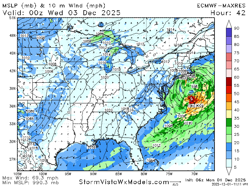
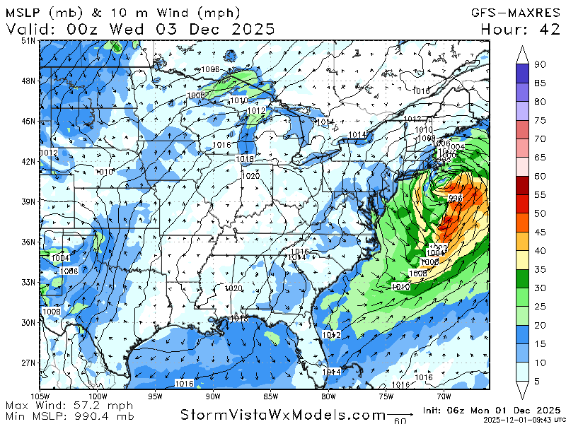
Love how euro is the warmer model. LOL. -
Have you ever considered a career in motivational speaking?
-
Ji, it’s the first day of the month man .
-
But my gut says to go with hrrr over euro at this point? Id think it has a better grasp of temps within 24 hours of onset than the euro? .
-

First Winter Storm to kickoff 2025-26 Winter season
HoarfrostHubb replied to Baroclinic Zone's topic in New England
He would lose his shit if it moved N a hair -

First Winter Storm to kickoff 2025-26 Winter season
MarkO replied to Baroclinic Zone's topic in New England
NWS map going with warmer solution. If it doesn't bomb, it's 2" of slop for me.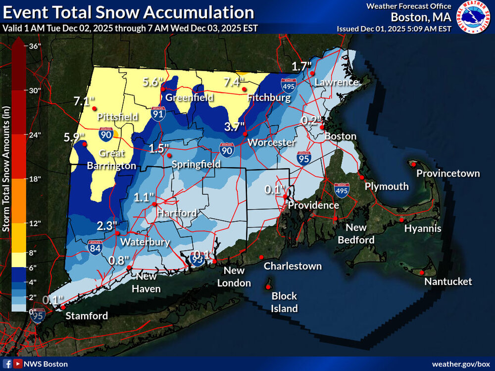
-
Let’s kick this off right. Would be nice to get on the board early. Looking good for a solid little event tonight.
-

Central PA Fall Discussions and Obs
Itstrainingtime replied to ChescoWx's topic in Upstate New York/Pennsylvania
MU was discussing this over the weekend and it seemed like he favored your area or just NE of you. He didn't seem thrilled for anyone SE of I-81. -

Central PA Fall Discussions and Obs
Voyager replied to ChescoWx's topic in Upstate New York/Pennsylvania
I'm going back to hauling water (a retirement opened up a day shift position) so I'd rather not win the low temp contest...lol -
First Winter Storm to kickoff 2025-26 Winter season
CoastalWx replied to Baroclinic Zone's topic in New England
That’s gonna be real close for Ray because it might be a little warmer below 925. -
Central PA Fall Discussions and Obs
Voyager replied to ChescoWx's topic in Upstate New York/Pennsylvania
The old saying of "you've got to smell the rain to get the best snow" may apply here. Whomever is close to the R/S line might be the ones to cash in, especially in the higher elevations. -
First Winter Storm to kickoff 2025-26 Winter season
CoastalWx replied to Baroclinic Zone's topic in New England
A good 50 mile shift from 12z euro yesterday. -
First Winter Storm to kickoff 2025-26 Winter season
CoastalWx replied to Baroclinic Zone's topic in New England
Euro at its height has the 925 0C line from about Ipswich to near Andover to probably nrn border of ORH and surrounding towns. -

First Winter Storm to kickoff 2025-26 Winter season
ineedsnow replied to Baroclinic Zone's topic in New England
-
First light salt run, one small lot,.equipment works lol
-
First Winter Storm to kickoff 2025-26 Winter season
ineedsnow replied to Baroclinic Zone's topic in New England
Still has that other low.. I don't think it moved that much? -
And the model showing the least snowfall is always correct. .
-
This month is turning into an unmitigated disaster. 48 hours ago we were looking at 3 threats lol
-

First Winter Storm to kickoff 2025-26 Winter season
moneypitmike replied to Baroclinic Zone's topic in New England
If I finagle the GFS amounts that it's tickling here, that'll be awesome. I'm not confident the qpf will merit that. It's tantalizingly close though. If the system can manage a little more latitude before shuffling east, all would be good. -
Dr no
-

12/3 Snow/Sleet/Mix Bag of Everything Discussion/OBS
Mikeymac5306 replied to Mikeymac5306's topic in Philadelphia Region
WWA hoisted for MBY -

First Winter Storm to kickoff 2025-26 Winter season
ORH_wxman replied to Baroclinic Zone's topic in New England
Yeah I think we’ve narrowed the goalposts down to just 25 miles or so but that still leaves a tough forecast because of how marginal the thermal profiles are across such a large area of more densely populated area. Metrowest down through Hartford region is gonna be a hard forecast. -
Reminds me of Jan 2024 when we got two northern stream waves that trended south with the PV push and hit us with a pair of 2-4"/3-5" snowfalls a week apart. And that was during an el nino winter, ironically. This is likely the best case scenario in a NS-dominant regime as depicted above.
-

First Winter Storm to kickoff 2025-26 Winter season
TauntonBlizzard2013 replied to Baroclinic Zone's topic in New England
Brutal sensible weather performance here. I’m sure it nailed H5 over Madagascar though.


