All Activity
- Past hour
-
The trick is to not even look at model guidance, maybe some twitter posts, and “guide” the weather to the outcome you want.
-
hammered?
-
Dressed for January, yes.
-
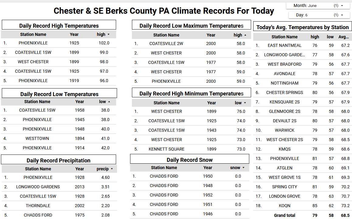
Today will be our last day with high temperatures near 80 degrees for about the 5 days. That is pretty close to the normal high for next week across the area. The good news is there is no sign of any 90-degree temperatures across Chester and SE Berks Counties till late June. Rain chances increase tomorrow and through the weekend but not a washout. The NWS has forecast of rain to be between a 0.25" to 0.50" by Monday morning. Generally showery weather looks likely to continue for Monday and Tuesday before we finally clear up and warm up to near 80 degrees again by mid-week.

-

E PA/NJ/DE Summer 2025 Obs/Discussion
ChescoWx replied to Hurricane Agnes's topic in Philadelphia Region
Today will be our last day with high temperatures near 80 degrees for about the 5 days. That is pretty close to the normal high for next week across the area. The good news is there is no sign of any 90-degree temperatures across Chester and SE Berks Counties till late June. Rain chances increase tomorrow and through the weekend but not a washout. The NWS has forecast of rain to be between a 0.25" to 0.50" by Monday morning. Generally showery weather looks likely to continue for Monday and Tuesday before we finally clear up and warm up to near 80 degrees again by mid-week.
-
That’s why I was originally thinking remaining along CT/MA border. Unfortunately, this may be the “best”/only opportunity of vacation so have to roll with it. Maybe Tuesday can offer something or next Saturday but too far out.
-
74 / 65 clouds to the lest , clouds to the right stuck in the middle with some sun. Warm / humid clouds are lined up to arrive later this afternoon capping most in the mid - upper 80s, but with enough sun could see a stray 90 or two (readings). Some isolated / scattered shower - storms later. Moving into another 72 - 96 hours of mainly grey / cloudy with chance of showers /storms each of the next 4 days Fri - Mon / Tue AM. Front / boundary slow to clear and hang by the area and coast eventually through Tuesday. Clear out Wed and warm up to / with the next shot at some 1-2 days heat Thu (6/12) / Fri (6/13) befor next front come through timing - weekend 6/14. Beyond there overall warm heat is focussed west with heights and more sustained heat heading east by the week of the 22.
-
I am in a slight.... nice
-
It was late May. I’ll see if I can find the storm reports.
-
I didn't think it was possible... but reading these forms, it might be harder to decipher whether its hot/cold in the summer than cold/snowy or dry in the winter . Seems like people make the models support there belief regardless of what it shows.
-
I was just checking Facebook to see if you knew lol
-
We had a setup in 2004 like this. All the action was on cold side of front but big time storms. Had two days of nickels and larger.
-
The constant jet extensions led to wild fluctuations in the WPO,EPO, PNA, AO, and maybe even the NAO. This would have been a great winter before the big warming jump in 15-16. We need a significant relaxation of this jet in coming winters for at least a small rebound off the record low snowfall and cuttter regime of the last 7 years.
-
If I had to chase I'd probably take my chances with the surface based instability in the valley S of HFD and just hope something pops. Could bust completely but higher upside IMO. Often further north has better dynamics but I just don't see them today.
-
yeah, I'm high confidence after eval that this was a wet microburst. Specific rad pulse took place as sat showed a circumvella over shooting anvil exploding radially, and then within moments we had timbre cracked wind/rain/hail for 5 minutes of hell. As Chris Farley would say .... " It was AWWesome"
-
yeah same here
-
It sucks shear blows.
-
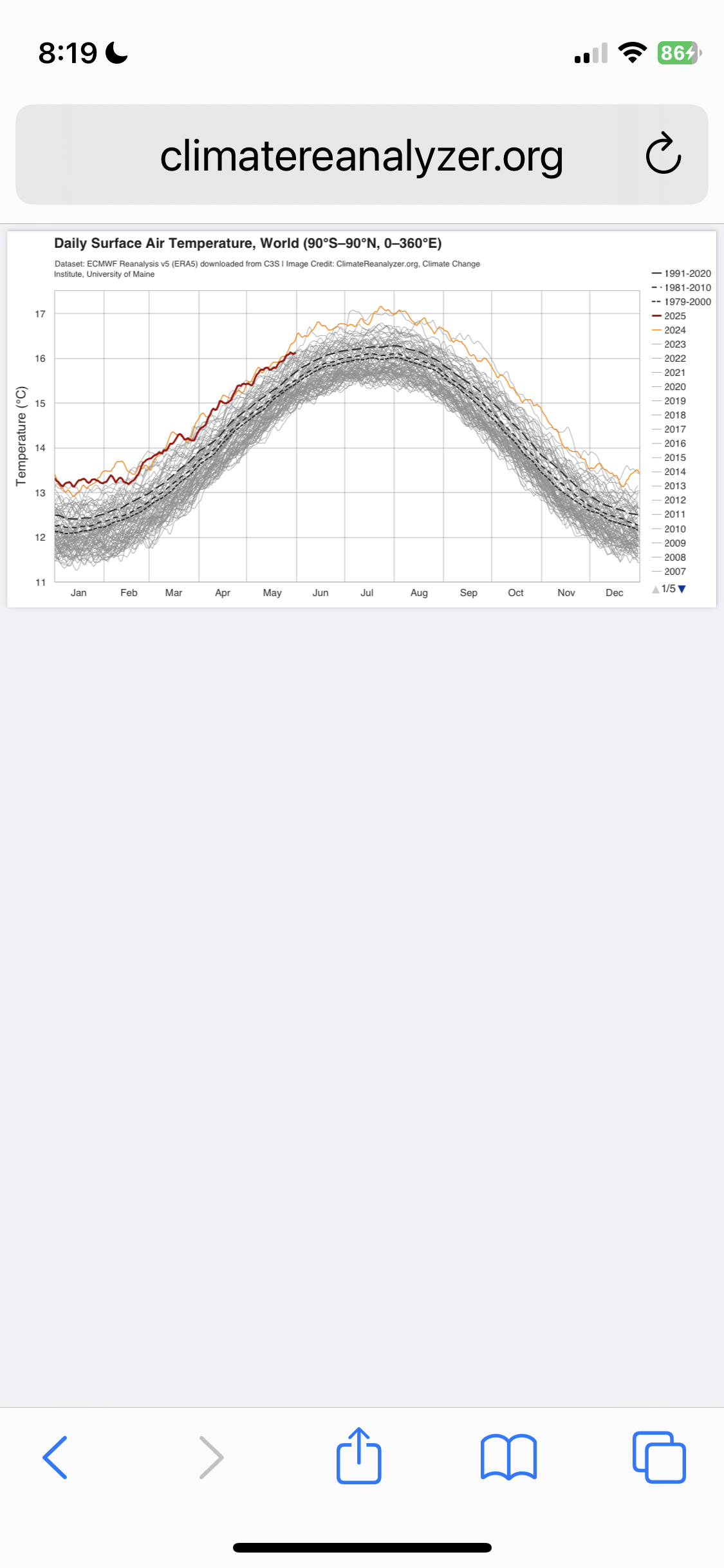
Here’s the global surface air temp. graph going through 5/31/25:
-
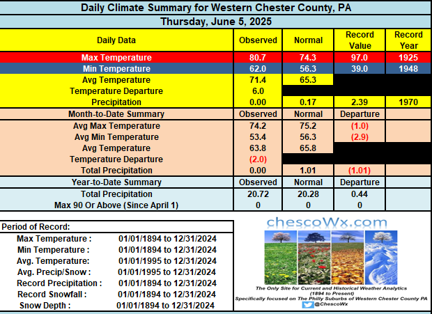
89 degrees for the high yesterday. .05” of rain from the showers that come through. Most stayed north of us. My AC is set at 68 degrees.
-
I can't get excited at all for setups with no shear and New England style high instability You want to give me >4k mucape pulsers maybe I'll raise an eyebrow, but otherwise meh
-
Maybe we can get close enough to the heat some for NW flow.
-
Meh. Heat is done. Even that period after next weekend looks meh.
-
Probably have to head to southwest NH today.
-
CIPS is *lit* at the 72hr frame. It even has June 1, 2012 in the analogs
- 938 replies
-
- 3
-

-

-
- severe
- thunderstorms
- (and 2 more)
-

2025-2026 ENSO
40/70 Benchmark replied to 40/70 Benchmark's topic in Weather Forecasting and Discussion
I'm speaking of the season in the aggregate...it was decidedly +WPO.