All Activity
- Past hour
-
Not the worst spot for the GEFS to be at D6-7


-
Of course, it is 150 hours out. The Ukie is 250 miles off the South Carolina coast. If anyone acts like they know a damn, they are lying.
-
Just keep it active, The chips will fall.
-

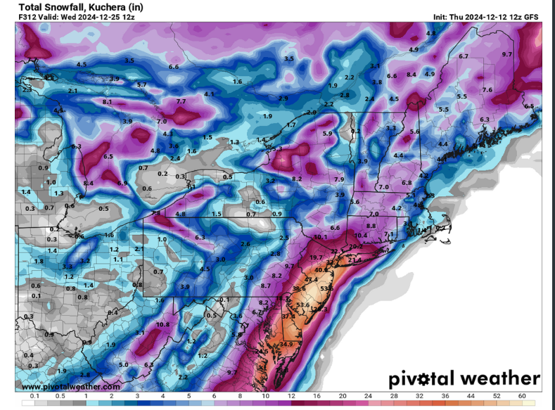
Nov 28-30th Post Turkey Day Wintry Potential
Stevo6899 replied to Chicago Storm's topic in Lakes/Ohio Valley
I think he may be doing us a favor by not including us in those maps. -
Bittinger and Frostburg mesonet sites showing a flip to westerly winds. Looks like the front is starting to crest the Eastern Continential Divide. Here's hoping we don't torch into the 70s prefrontal.
-

Nov 28-30th Post Turkey Day Wintry Potential
michsnowfreak replied to Chicago Storm's topic in Lakes/Ohio Valley
Please also include eastern lower MI on those maps -
LOL at the end of that run trying to form a Hudson Bay block....that would probably produce all sorts of craziness. That's actually how Dec 19-20, 1995 happened.
-
Gang is returning
-
12z GFS really tries to see something up around the 5th, 8th, and 10th. If we can't score at least climo snowfall then we'll need a regional exorcism.
-

November 2025 general discussions and probable topic derailings ...
CoastalWx replied to Typhoon Tip's topic in New England
Shorts and low 60s. -
Ukie is very weak
-
Semi violent gfs run
-
-

E PA/NJ/DE Autumn 2025 Obs/Discussion
simbasad2 replied to PhiEaglesfan712's topic in Philadelphia Region
The 12z GEFS ensembles arent terrible imo... -
Gefs
.thumb.png.3f804b86c29a654e522ff068ddf29ba7.png)
-
It's like watching commercials for Vegas when everybody wins on every spin!
-
ICON also joined the party
-
Gfs with vodka cold next weekend (GGEM agrees), then a clipper goes Miller B for a high ratio powder storm. Lol
-

December 2025 Short/Medium Range Forecast Thread
Daniel Boone replied to John1122's topic in Tennessee Valley
Yeah, probably low Dp at onset. Hopefully we get a stronger push of cold with the follow-up System the 2nd. As is, a rain to snow in upper Valley at the end. If Models are correct, Northern VA and much of West Virginia are going to get buried. Much of Kentucky looks to get a good amount as well. -
On the live webcam from mount Washington there were some cool looking clouds around 645 am.. not sure when this is from
-
A reminder for those who have incorrectly stated that we had nothing to track early last winter...
-
GFS already corrected north and it's likely not done. Cimo favors the interior heavily. Catskills and Poconos should get a really nice event.
-
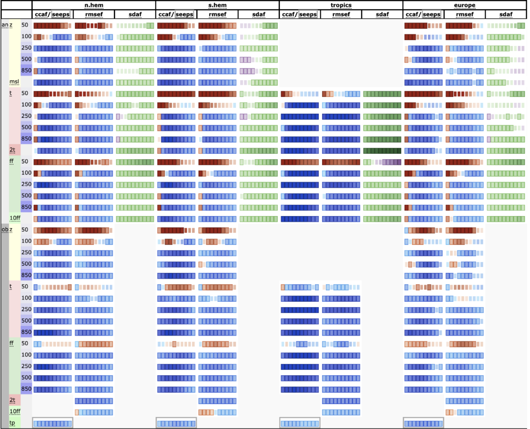
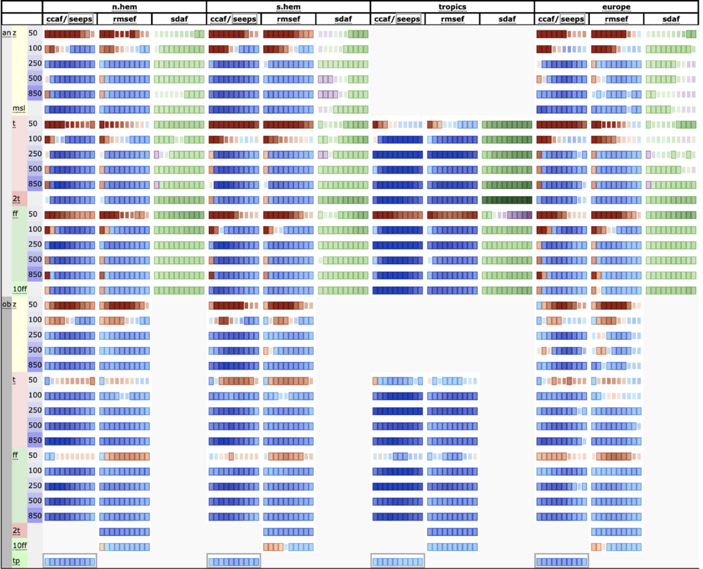
AIFS scorecard over operational (blue=improvement). Ryan Torn suggested that systematic under performance at 50mb was because the NWP models it's train on aren't actually very good at simulating the physics of the stratosphere, so it's learning incorrect conclusions and then applying them in full force.
-
Agree with most of this, but think the second half of December could be interesting. The 2-3rd threat is real, but id favor NW of both of us for plowable snows at this stage. If we can thread the needle and squeeze out 4-8 inches that would be awesome, but those mild early Dec ocean temps are going to be working against us. Still worth keeping an eye on though.
-
And the ukie aka crazy uncle squashed the 12/2 threat at 12z


.png.7ea384192451b0911cba89aa5c7a3398.png)


.thumb.jpeg.406ecda2eec9e267302c22b9f128fe3c.jpeg)