All Activity
- Past hour
-
I’m surprised at how long this thaw is. Really defined the first half of the month aside from the first 6 days that were average or well below average. Tomorrow is the 14th and we’ll still be 10 degrees above average. At this point it’s not a thaw, it’s a running theme that CONUS has been quite warm this month
-
That’d be a fun drive out to a long weekend at Wisp with the wife and kids in the family truckster. I’m in.
-
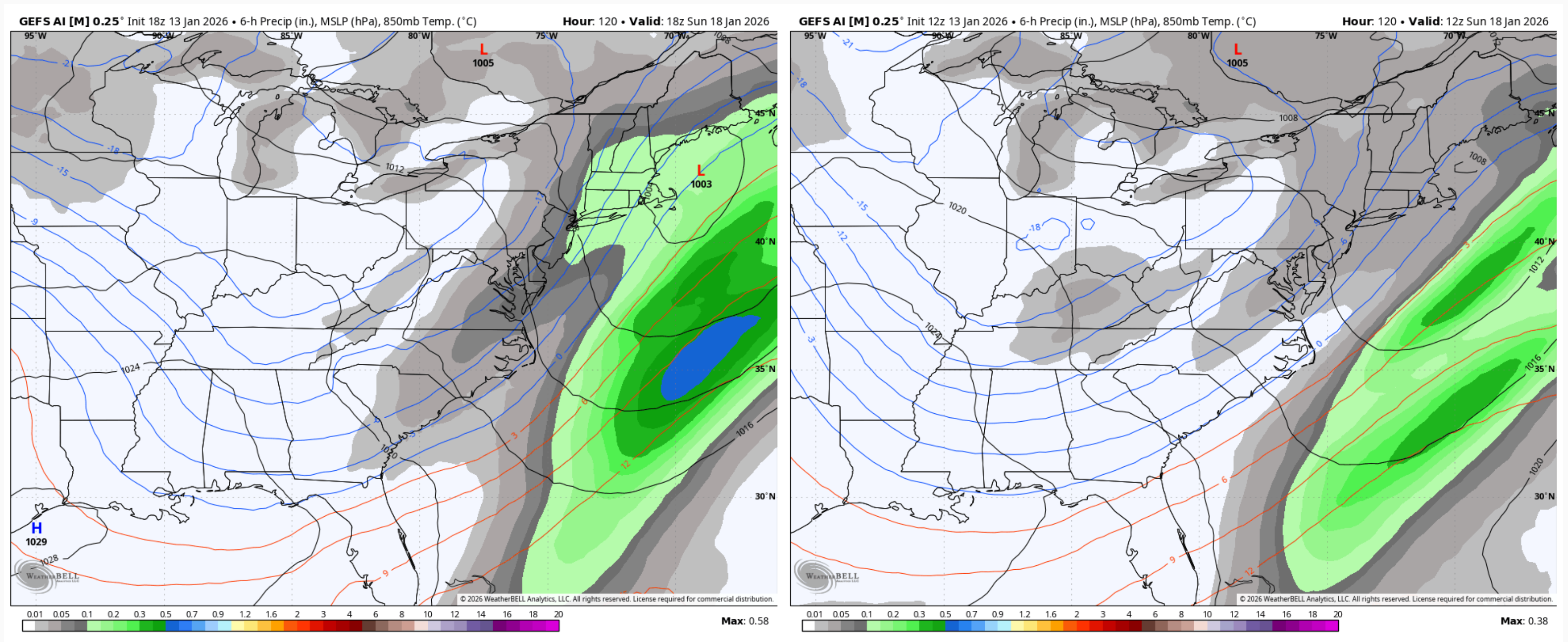
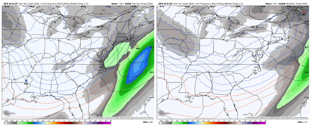
Yes only 34.6 for me. I'm hoping the 0Z run shifts the 40-50 inch line a little east.
-
I understand how a neg pna typically hurts us but I'm wondering how else we get a wave to track like the 18z shows. I understand that this is a traditionally -pna with a low in the southwest. However, like you said it is progressive so this low moves eastward and throws moisture up in front of it (alongside the WAA and ridging as a result of it impacting the flow). So to my (flawed) understanding wouldn't having higher heights in the pna region basically mean our storm doesn't exist/is far weaker? Or alternatively the pna is more positive which results in the storm rolling off the ridge at a higher latitude before dipping eastward in a trough, which seems like it would cause even worse thermal issues. I guess I'm just struggling to see how else we get a SWFL event without a negative or neutral PNA.
-
Though it’s not easy without 6,34, and 43. They should all be back soon
-
It was like I watched two different teams for periods 1/2 and period 3 tonight.
-
Good summary for you by LWX - snipped the portion about Friday into Saturday: KEY MESSAGE 3...A low pressure system may bring snow to the Allegheny Mountains Friday through Saturday night. One, possibly two low pressure centers will meander through the Great Lakes Friday into Saturday as a series of shortwave troughs result in amplifying long wave troughing into the eastern US. There may be some light snow showers along the Allegheny Mountains on Friday, but the higher chances will arrive Friday night through Saturday night as the main trough approaches. Temperatures may attempt to rise above freezing Saturday in some of the valleys before the cold front pushes through, but profiles will be cold enough for all snow for most locations along and west of the Allegheny Front. Accumulations resulting in travel disruptions are possible. To the east of the Alleghenies, there are mixed signals whether any precipitation falls, but it will be related to the push of warm advection Saturday morning and/or the cold frontal passage Saturday afternoon/evening. Some snow or a mix could occur depending on the timing of any precipitation, but at the moment, impacts appear limited at the lower elevations. For temperatures, Saturday is expected to be the warmest day of the weekend before the cold front pushes through.
-
Caps do this shit all the time - these mid-season periods where they look like garbage for a bunch of games in a row.
-
High today was 47, still 43 now. deep winter according to some!
-
Let’s gooooo Caaaaps!! That was the best 3rd period of hockey they played all year. Ethan Frank is a beast! Awesome W in OT! PS—first two period I was literally booing my tv. lol. They better fix some stuff.
-
are watches up yet?
-
Normally a negative PNA would dump the cold west of us causing storms to cut, pumping the SER. In this case, hopefully its more transient but atm we may have temp/mixing issues as storms attempt to cut while cold air presses it south. We can hope it continues to trend in our favor as @Chris78 just showed a few posts above. A mildly negative or neutral PNA shouldn’t hurt in our case.
-

January 2026 regional war/obs/disco thread
The 4 Seasons replied to Baroclinic Zone's topic in New England
AI GFS/ AI ENS both came W/NW for the Sun 18th wave fwiw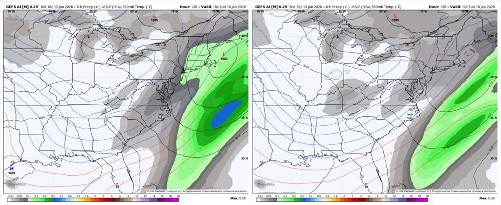
-

Central PA Winter 25/26 Discussion and Obs
pasnownut replied to MAG5035's topic in Upstate New York/Pennsylvania
Hey man. Good to hear from you. Glad that you are liking where we are headed. Lets just hope baroclinic zone wavers south for some of these. SWFE's are some of my favorite, as frequency is usually every couple days, and ya just need to see what side of the snow fence you are on for each of them. -
The 24h period between noon tomorrow and noon Thurs looks like its going to be wild... 3k Nam has 2m temps going from 41 to 10. I'm expecting 3-4" on the ground and still coming down by the time I get up there and really hoping GFS is right. 18z Kuchera showed about a foot
-

Pittsburgh/Western PA WINTER ‘25/‘26
Gordo74 replied to Burghblizz's topic in Upstate New York/Pennsylvania
My family has already called me alarmist for next weekend, so I’m trying to temper my expectations. Looks like it could be a multi-day event with double digit payoff. Can’t be upset about that, but can’t get too excited yet for we all have been too hyped this far out before. -
Central PA Winter 25/26 Discussion and Obs
pasnownut replied to MAG5035's topic in Upstate New York/Pennsylvania
If this news gets published here.... I might not have anyone to chat w/ me anymore.....hehe edit: i see it has..I'm wonding if Im being purged as we speak. -
Stop. Please just stop. 7 days out, do you ever learn.
-
woohoo!!!! Caps win! Hoos win!!
-
See ya there! Going up to the house Friday - Monday. Good call, it’ll give you a snow fix ahead of our epic SWFE
-
Central PA Winter 25/26 Discussion and Obs
pasnownut replied to MAG5035's topic in Upstate New York/Pennsylvania
Might be headed to cabin this weekend. Not sure yet. I'm told the weekend rain froze and made it a real icy mess up on the hill. Mtn roads are almost impassable. Do you agree? Looks like a couple inches coming tomorrow night. If wet, it'd prob help. If fluffy....ugh. We were slippin and sliding 2 weekends ago. Groin still recovering, but I'd like to get up. -
Great comeback win by the Caps!
-
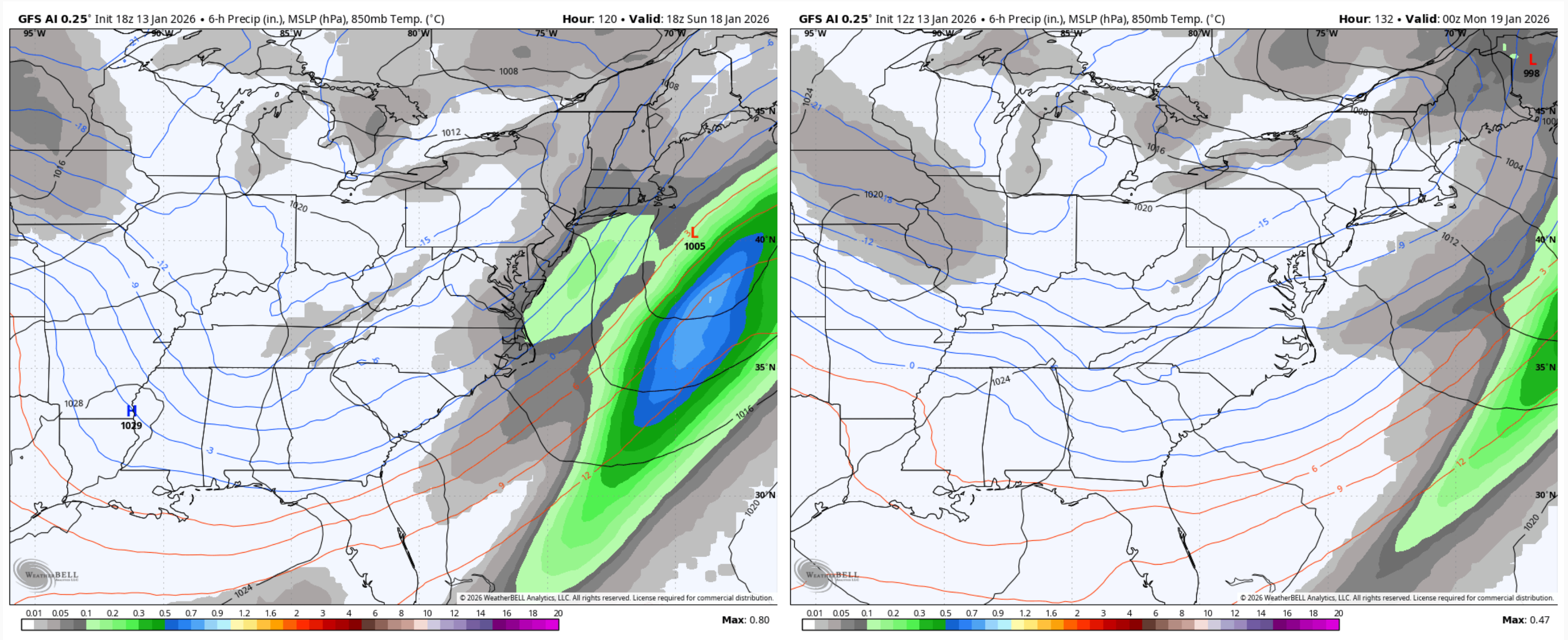
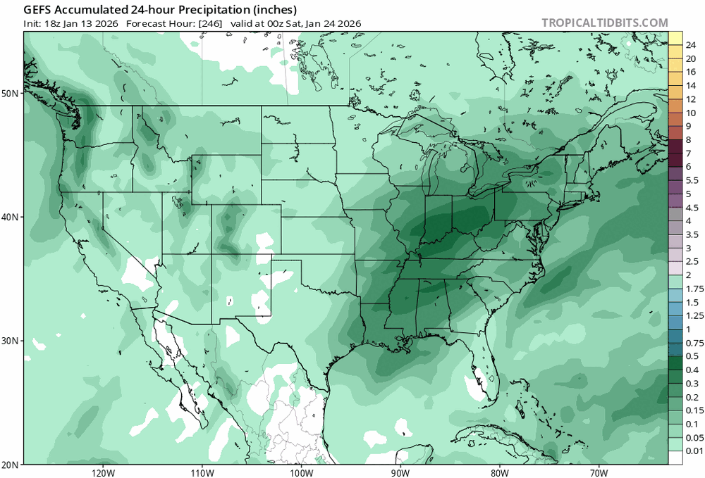
With this moisture during the time frame shown above.
-
I mean given the tendency to over-model the SE ridge this winter, I think the 23-26 period definitely deserves cautious attention. Even for a storm that ultimately is gonna go too far north, fight off the ridge a little and I could imagine getting a frontend thump out of a nice shot of gulf moisture while we still have some cold. Or honestly, just imagine the setup as depicted on the GEFS right now just moves east some. It has trended eastward since this morning. That could put us much closer to the bullseye. Besides, this is real Gulf moisture. Not ready to be pessimistic about it!