All Activity
- Past hour
-
This is the most frustrating drizzle fest I've seen since the last one lol. Oh look! Another batch of rain headed towards the same area that keeps getting hit while the rest of us get scraps.
-
Kids hammered.
-
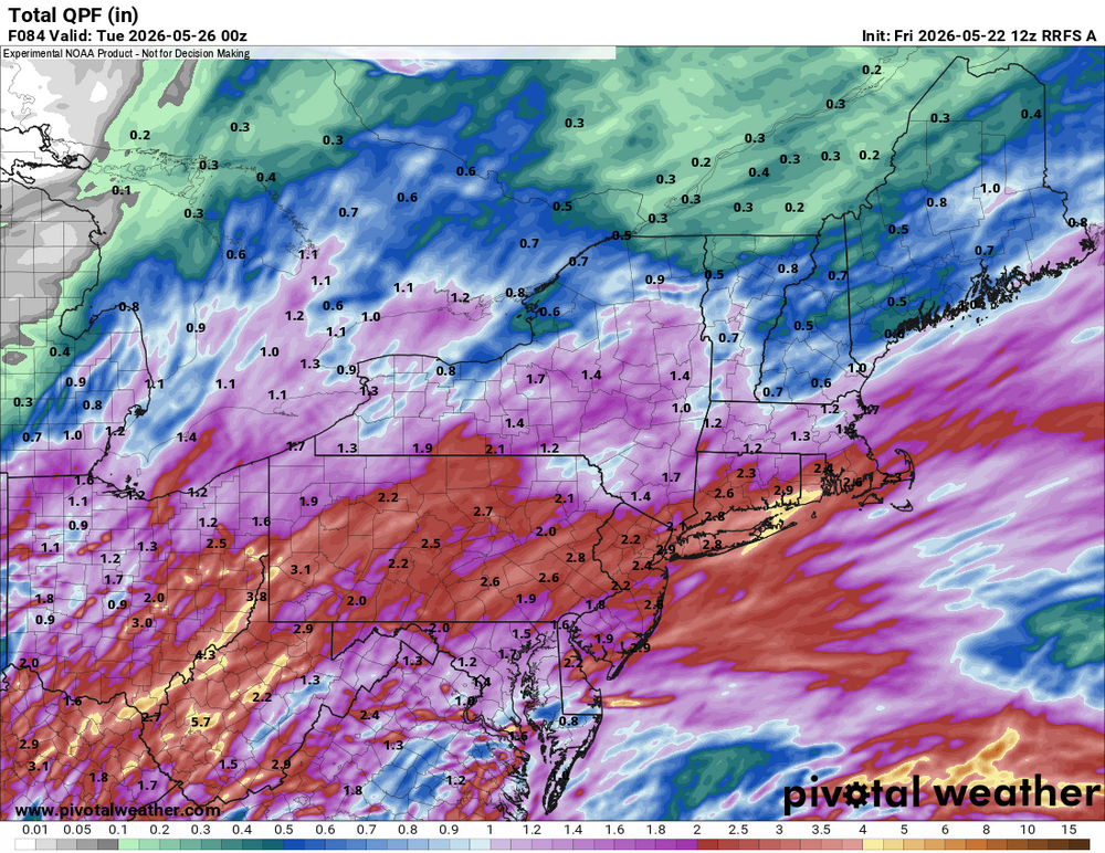
I'm giving greater weight to the AIFS/ECMWF, as the 18z GFS reduced totals from the 12z run. I do think 2" amounts are most likely across eastern PA into western NJ. The City and nearby suburbs should generally be 1.00"-1.50" in my thinking, but parts of CT away from the coast will have lower amounts (0.50"-1.00"). That's why I used 0.50"-1.50" with some locally higher amounts for the general NYC area. On the other hand, the NBE has grown wetter with amounts near 1.70" in and around NYC.
-
Don't look now but yet ANOTHER line of storms is forming then may hit my backyard tonight. And all that moisture - make NO mistake about this - IS heading straight to the DCA Region. I think there is a possibility that autumnal Super Ninos may exert on the N Hem even in Spring. Uh-Oh. My mower has been sputtering. Better get that Ark built stat.
-
July will be rockin'
-
E ATL burbs doing quite well though. Does anyone have a link to radar estimated rainfall?
-
https://www.loveagain.app/find-a-wife.html
-
Rufus is wet
-
why are you going for much lower rainfall totals than Upton ?
-

Devastating tornado strikes Joplin, Missouri
bkviking replied to Hoosier's topic in Weather Forecasting and Discussion
Memories of this on 15th anniversary… -
Yes. I remember it well. The afternoon snow squall, even as it was short-lived, was quite impressive.
-
Man 93 95 and 94 for highs MTW and then 61 twenty four hours later and 58 at same time today
-
Following the Joplin thread 15 years ago is still intense.
-
We had snow that week too-accumulated briefly on some colder surfaces...
-
Next 10 days. Bleh
-
0.41"
- Today
-
May 9, 2020 at JFK Airport (tied), LaGuardia Airport, and White Plains (tied). For Bridgeport: November 23, 2018 For Islip: June 1, 2009 For New York City-Central Park: August 29, 1986 (tied) For Newark: August 29, 1982
-
Your old friends from the thread just to your north miss you… Please drop by & check in sometime. Miss you man…
-
One of the worst Memorial Day weekends (for outside fun) I can recall.
-
With the nino we could see a wetter summer....
-
Clouds will increase tonight. Rain will develop tomorrow and continue into Sunday. A general 0.50"-1.50" rainfall is likely. Some locally higher amounts are possible. The temperature will likely remain in the 50s all day on Saturday and struggle to reach the lower 60s on Sunday. The mercury will likely return to the lower 70s on Monday. The ENSO Region 1+2 anomaly was +1.8°C and the Region 3.4 anomaly was +0.9°C for the week centered around May 13. For the past six weeks, the ENSO Region 1+2 anomaly has averaged +1.63°C and the ENSO Region 3.4 anomaly has averaged +0.70°C. El Niño conditions are now in place. The ongoing El Niño will continue to strengthen through the summer. The SOI was -19.74 today. The preliminary Arctic Oscillation (AO) was +0.868 today. Based on sensitivity analysis applied to the latest guidance, there is an implied near 66% probability that New York City will have a warmer than normal May (1991-2020 normal). May will likely finish with a mean temperature near 63.8° (0.6° above normal). Supplemental Information: The projected mean would be 1.3° above the 1981-2010 normal monthly value.
-
lol huh? That’s Stein depicted
-
Sending you all some rain from the Deep South/Southwest!
-
Are we losing Sunday ?!?
-
1.83 so far id love to hit 2" today


