All Activity
- Past hour
-

12/14: Sunday funday? Will the south win again?
winter_warlock replied to TSSN+'s topic in Mid Atlantic
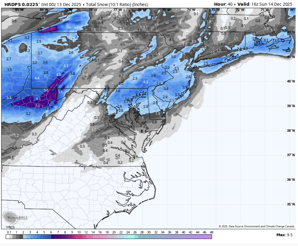
Yeah I'm thinking all of central md right up thru NE Maryland Into se Pa -
GFS looks very similar to 18z through 27. Looks like a slightly more organized interaction with the TPV, maybe that juices it slightly, more coastal-y?
-
Gfs continues to slowly tick nw with qpf shield. Had nothing over me this morning now into the light snows.
-

December 14th - Snow showers or Plowable snow?
weathafella replied to Sey-Mour Snow's topic in New England
Yes gfs coming in decent. -
Baltimore looking pretty damn good for 3+
-

Minor snowfall sunday 12/14/25 1-4” possible
jm1220 replied to WeatherGeek2025's topic in New York City Metro
I wouldn't say it got "much worse". I'd say it largely held serve. Small fluctuations are really just noise. The setup is that a trough is diving SE and a shortwave is developing a coastal low that's headed NE quickly. It's not a setup for heavy snow anywhere and the diving SE trough is bringing in dry air. So I do believe there'll be a zone where there's a lot of virga because of dry air coming SE and in any given location there won't be snow for more than 6 hours or so. The S coast of CT is in the game for a light event still. -

Minor snowfall sunday 12/14/25 1-4” possible
Nibor replied to WeatherGeek2025's topic in New York City Metro
"Much worse" -
herp derp also good

-
CPC now has the 8-14 day period stormy in the Southwest, which is consistent with the storm timing at the 17-21 day lead I posted a while ago. Also, we have the big warm up coming as expected. If you remember, the Canadian showed the US not very cold for December, despite the big cold wave everyone knew was coming early month. So it looks like the model did a pretty good job. Longer term, the look over NE Asia right about now looks like a big high centered over the Plains and a potent low over the SW US or Northern MX in 17-21 days, roughly in the Dec 29/30 to Jan 2/3 window.
-
Snow covered when it was so cold?
-
These that start out drizzly and light rain , when they mix and changeover there is usually good energy following Plus when snow ends Sunday and it’s very windy 20-30 gusting to 40; 2” would be enough to blow around well
-
Idk what's going on but my petunias are still alive and blooming. It's not like it's been anomalously warm or anything. We've had hard freezes obviously. Strange.
-
My boys?! LOL. I did have a shot to get in on that back in the day, true story, but stepped away. I guess I missed my shot at the big time, oh well.
-
Minor snowfall sunday 12/14/25 1-4” possible
203whiteout replied to WeatherGeek2025's topic in New York City Metro
lol these posts are so biased on “location”. RGEM got much worse for northern fringe areas and south coast of New England. All models seem to be catching onto the idea of a very sharp cutoff to the north. Seems like the southern New England snow drought continues at least into January. Enjoy it down in LI and Jersey . -

Central PA Winter 25/26 Discussion and Obs
Ruin replied to MAG5035's topic in Upstate New York/Pennsylvania
that would be nice but I looked up my weather on this day and got this
-
Oh you'd get the lightning, but no snow
-

12/14: Sunday funday? Will the south win again?
Maestrobjwa replied to TSSN+'s topic in Mid Atlantic
What the heck did it just fart out? Lol -

December 2025 regional war/obs/disco thread
H2Otown_WX replied to Torch Tiger's topic in New England
Jk, that actually does look pretty nice. Let's roll with that look right through Jan. -

December 2025 regional war/obs/disco thread
Snowcrazed71 replied to Torch Tiger's topic in New England
My family and I are heading up to Canada the day after Christmas. We're going to be up there for 4 days. Hopefully the ride won't be terrible, but I'm sure they're chock full of snow up in Quebec City -
December 2025 regional war/obs/disco thread
H2Otown_WX replied to Torch Tiger's topic in New England
Congrats DC -
I remember the 35 inches it gave us 4 years ago
-
Getting woken up to puking snow by lightning and thunder would be sick
-
December 2025 regional war/obs/disco thread
H2Otown_WX replied to Torch Tiger's topic in New England
Fake (warmup) 'n Take Freeze Out -

December 2025 regional war/obs/disco thread
RUNNAWAYICEBERG replied to Torch Tiger's topic in New England
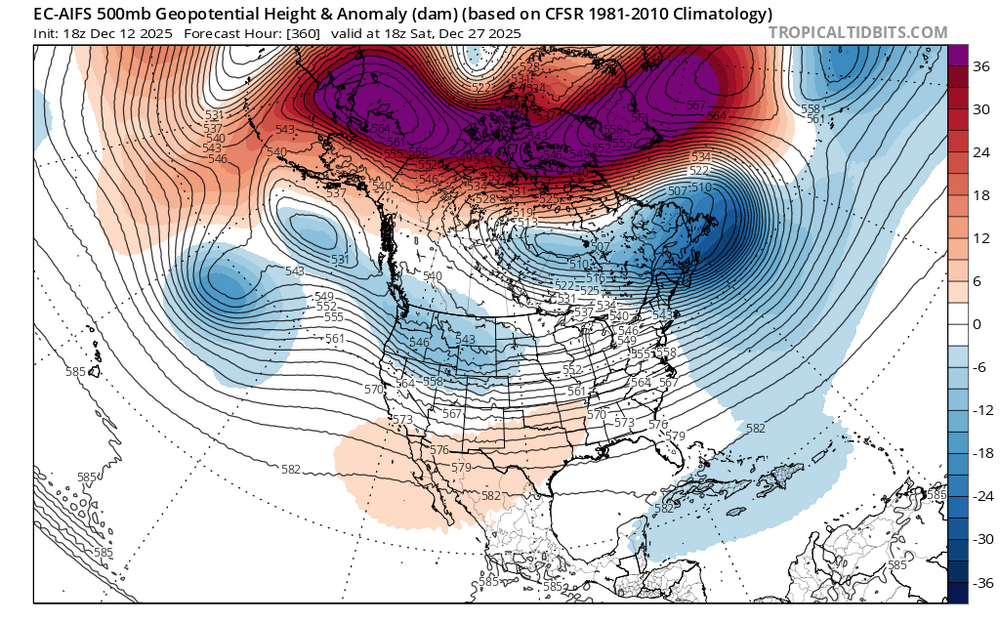
-
12/14: Sunday funday? Will the south win again?
winter_warlock replied to TSSN+'s topic in Mid Atlantic
Wtf is that? Lol