All Activity
- Past hour
-

December 2025 regional war/obs/disco thread
WinterWolf replied to Torch Tiger's topic in New England
When you have multiple IPA’s…that’s when. -
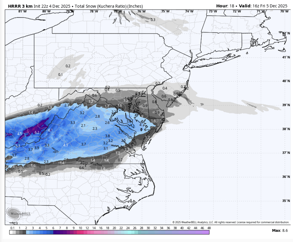
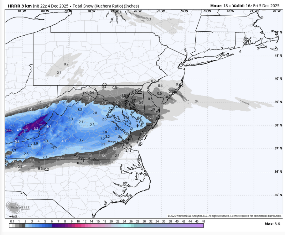
Probably redundant (and if so mods may delete this) but the 22z HRRR is a significant shift north, and it is still snowing at the runs end. Likely would amount to 2-2.5" in DC.
-

December 2025 regional war/obs/disco thread
moneypitmike replied to Torch Tiger's topic in New England
I'm watching The American Revolution, too!! -
34/21

-
In all seriousness, snow ratios are very difficult to predict with the kind of accuracy we want. Your point about lift being displaced from the DGZ is a good one and probably worth not getting too hopeful of >10:1. But even if we don’t have beautiful dendrites, we should have plates and those are usually 10:1 or so. Needles are the danger zone…those accumulate like sand. Often 5-6:1.
-

Central PA Fall Discussions and Obs
Blizzard of 93 replied to ChescoWx's topic in Upstate New York/Pennsylvania
CTP has the forecast low at 14 tonight for MDT. The remaining snow cover could help the temps to bottom out. Current dew point is 13 at MDT. -

December 2025 regional war/obs/disco thread
SouthCoastMA replied to Torch Tiger's topic in New England
How and when were January and February ever not the top two? Outside of random years I guess -
December 2025 regional war/obs/disco thread
WinterWolf replied to Torch Tiger's topic in New England
Shoot that POS. -
December 2025 regional war/obs/disco thread
WinterWolf replied to Torch Tiger's topic in New England
Definitely. -
18z euro just totally meh Sunday night.
-
December 2025 regional war/obs/disco thread
WinterWolf replied to Torch Tiger's topic in New England
No. It didn’t. Just look at the normals. But it has at times-Like this year. We take. -
Many many beers
-
December 2025 regional war/obs/disco thread
WinterWolf replied to Torch Tiger's topic in New England
Ya them and Alabama and New Orleans too…foot plus with blizzard conditions right on the beaches…and also 40 miles or so off shore into the gulf. -
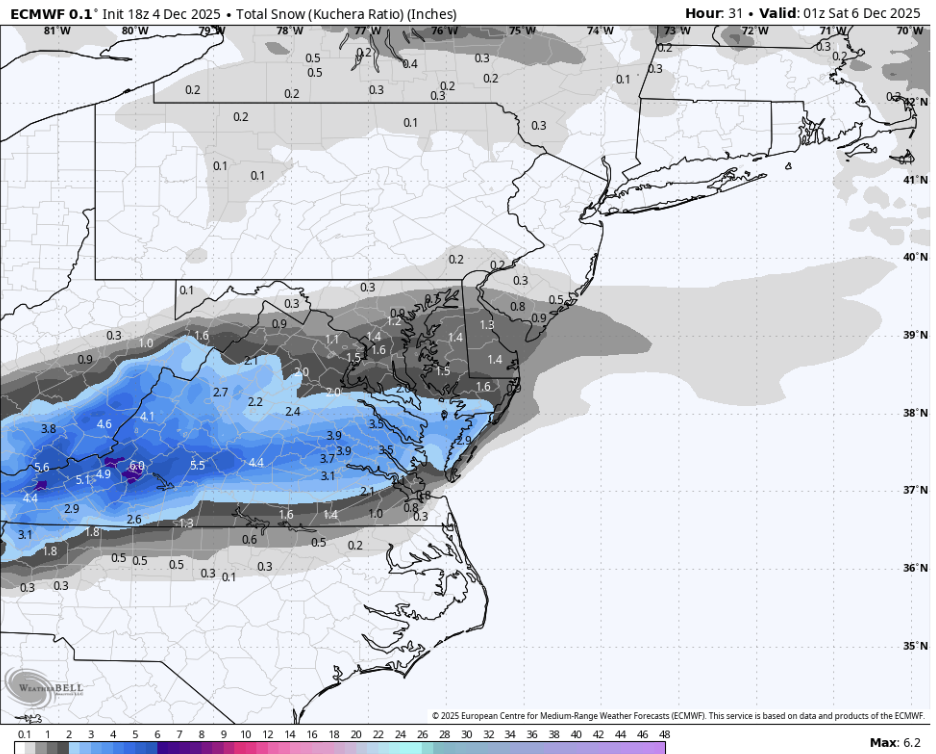
18z Euro is relatively unchanged DC and points north, but totals are slightly less DC south

-
Mix lol
-

December 2025 regional war/obs/disco thread
Damage In Tolland replied to Torch Tiger's topic in New England
Every year it used to happen . December used to be 2nd best winter month . For many , many years -
Barney cold on the gfs
-
Well said, well done Don. As always ….

-
December 2025 regional war/obs/disco thread
SouthCoastMA replied to Torch Tiger's topic in New England
I didn't like it verbatim, even at 12z. Leaving some room for this to dig further south, but not holding my breath for additional positive trends. Just watching -
Fully expecting brown ground again within next 2wks. Sent from my SM-S921U using Tapatalk
-
At least we aren’t watching Pensacola FL get a blizzard like last year.
-

Central PA Fall Discussions and Obs
WE GOT HIM replied to ChescoWx's topic in Upstate New York/Pennsylvania
Hii -
If you're on the east coast more moisture will be involved. Mostly everyone else its clipper type systems...which can produce, but not your big winter storms. The exception may be potential around the 12th.
-
Montgomery County just blasted this email to everyone (parents/staff/etc): MCPS is closely monitoring the weather forecast for Friday morning. Current weather forecasts indicate the possibility of a wintry mix beginning earlier than expected, which may affect travel conditions for students and staff. We are checking with our county partners and continue to evaluate timing, possible road conditions, and impacts to school operations. If any changes to school schedules are needed, we will notify families and staff as soon as possible through all normal communication channels.
-

December 2025 regional war/obs/disco thread
powderfreak replied to Torch Tiger's topic in New England
On Christmas Day.