All Activity
- Past hour
-

Outta gas and Outta Time: Early March Winter Storm finale
Terpeast replied to Ji's topic in Mid Atlantic
28.8/17. Guess this time we’re not chasing moisture with cold air -
.thumb.jpg.6a4895b2a43f87359e4e7d04a6fa0d14.jpg)
Central PA Spring 2026 Discussion/Obs Thread
Yardstickgozinya replied to Voyager's topic in Upstate New York/Pennsylvania
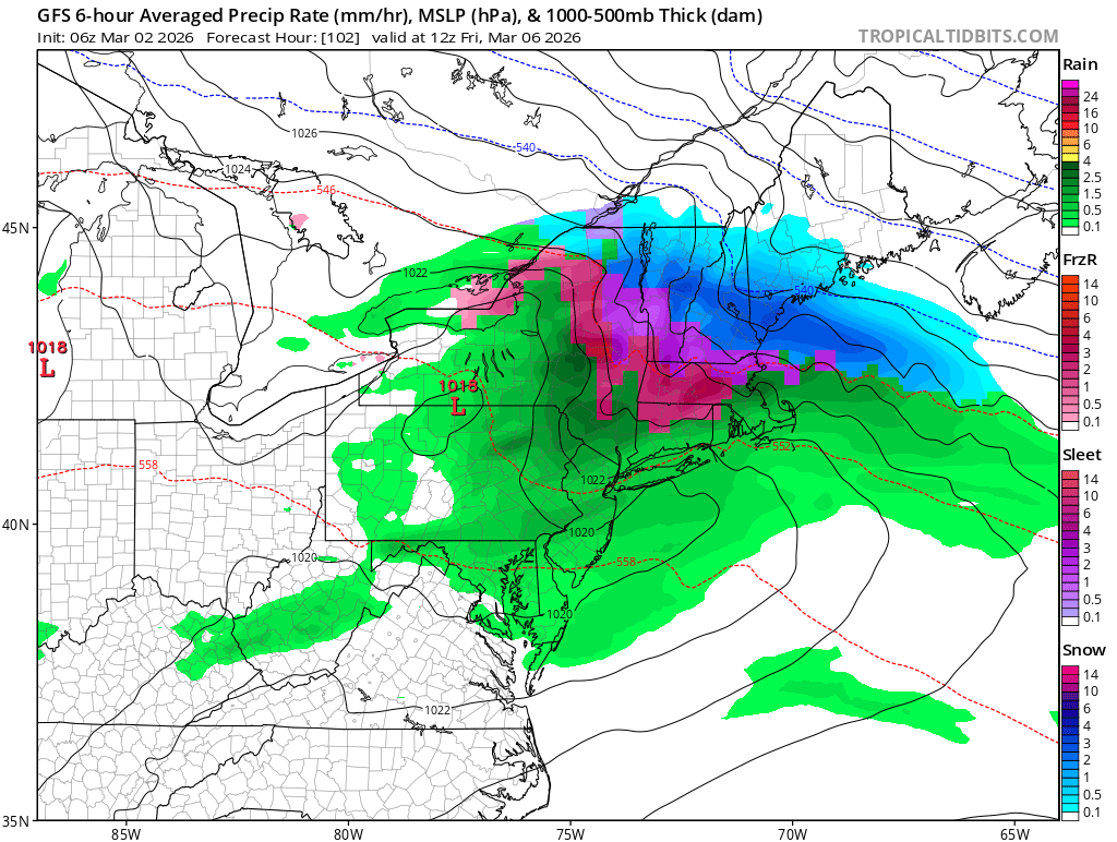
This is not the full forecast discussion. I only posted discussion on Tuesday mornings mixed precipitation/ ice event. Highlight Changed Discussion -- 120 FXUS61 KCTP 020800 AFDCTP Area Forecast Discussion National Weather Service State College PA 300 AM EST Mon Mar 2 2026 .WHAT HAS CHANGED... * Posted winter weather advisory for freezing rain for almost all of the forecast/warning area for later tonight and Tuesday morning. && .KEY MESSAGES... 1) A light wintry mix with light freezing rain accumulations likely late Monday night into Tuesday morning. 2) Periods of rain with temperatures very much above normal Wed onward. && .DISCUSSION... KEY MESSAGE 1: A light wintry mix with light freezing rain accumulations expected later tonight into Tuesday morning. Over the past 24 hours, the model solutions have come into better alignment w.r.t. timing. The QPF and temperatures have been very consistent from run to run. P-type will be a varied mix at first, but the gradual warming aloft will turn the precip to liquid. The consistency has raised our confidence in a light glaze of ice occurring late tonight and Tuesday morning. We wondered whether it is a little early to post the advisory at this range (24-30hrs before start of the hazardous wx). But, the forecast has been highly consistent at painting measurable amounts of ZR over the entire CWA. WPC guidance, FRAM progs from HREF, and NBM forecasts all add together to make a high confidence forecast for a thin glaze of ice accretion in most places. We kept the goalposts wide on timing, that is, erring a little early on start of the ZR, and a little later than when the ZR should be done in each area. This should help our partners to be ready should it move in a little faster or end a little later. We didn`t want to call for too tight of a window. In all likelihood, the valley locations probably have more like a 3-6hr time period when ice may accrete before the temps warm enough to make it plain rain. But, the hills/ridgetops can stay sub-freezing longer into many events. For example, the 00Z NAM and GFS BUFKIT soundings both turn the precip type at UNV (1150ft MSL elevation) to plain rain at 17Z. At that time, though, the temp profile has the temps at 1000ft still sub- freezing. Our surrounding ridges are that high above the valley floor (1900-2400ft MSL). That may be due to a boundary layer of the cold air staying in place while the warmer air works down from above - and the valley sfc warms due to the sun. On the other hand, the fast (30-50KT) winds in the LLJet of the warm advection could mix/force the warm air down onto the ridgetops before or at the same time as the valleys gets warm. But, from personal observation, the scenario where the ridges stay colder-longer than the valley is just as common. The arrival time of the precip lends itself to keeping the temps colder-longer. As for the NW: The northwestern zones may also need an advisory eventually, but confidence is just a little lower there for a glaze to occur. The temps may warm just enough before precip starts to keep it all rain. Collaboration among the WFOs resulted in holding off on issuing for them (Warren and McKean) on this shift. NAM hints at the llvl moisture increasing before the higher clouds drop larger hydrometeors into it. Thus, there could be some freezing drizzle before the main push of mix arrives. This is another reason to start the advy a little earlier than most of the guidance brings the measurable precip in. The criteria for a winter weather advisory for freezing rain as the threat is: any. Even if it just the thinnest of glazes due to the hazard it presents to travel, even on foot. -
Add BAMWX to the growing chorus of people skeptical of some big return to winter come mid-month. Contentweatherguy and Larry Cosgrove in his new blog yesterday morning are also doubting it Larry Cosgrove: https://groups.google.com/g/weatheramerica/c/rkjQBLeS9xo
-
Central PA Spring 2026 Discussion/Obs Thread
Yardstickgozinya replied to Voyager's topic in Upstate New York/Pennsylvania
Get your snow blowers ready lol Winter Weather Advisory URGENT - WINTER WEATHER MESSAGE National Weather Service State College PA 201 AM EST Mon Mar 2 2026 PAZ017>019-025>028-056-057-059-063-065-066-022115- /O.NEW.KCTP.WW.Y.0013.260303T0900Z-260303T1800Z/ Clearfield-Northern Centre-Southern Centre-Blair-Huntingdon- Mifflin-Juniata-Perry-Dauphin-Lebanon-Cumberland-York-Lancaster- Including the cities of York, Philipsburg, Carlisle, Lebanon, Newport, DuBois, Mount Union, Harrisburg, Hershey, State College, Mifflintown, Lancaster, Clearfield, Altoona, Huntingdon, and Lewistown 201 AM EST Mon Mar 2 2026 ...WINTER WEATHER ADVISORY IN EFFECT FROM 4 AM TO 1 PM EST TUESDAY... * WHAT...Mixed precipitation expected. Total ice accumulations up to one tenth of an inch and snow accumulations less than one inch. * WHERE...A portion of central Pennsylvania. * WHEN...From 4 AM to 1 PM EST Tuesday. * IMPACTS...Plan on slippery road conditions. The hazardous conditions could impact the Tuesday morning commute. * ADDITIONAL DETAILS...A light glaze of ice is expected late tonight and Tuesday morning, especially on the higher elevations. PRECAUTIONARY/PREPAREDNESS ACTIONS... Slow down and use caution while traveling. The latest road conditions for the state you are calling from can be obtained by calling 5 1 1. && $$ Hazardous Weather Outlook Hazardous Weather Outlook National Weather Service State College PA 428 AM EST Mon Mar 2 2026 PAZ017>019-025>028-056-057-059-063-065-066-030930- Clearfield-Northern Centre-Southern Centre-Blair-Huntingdon-Mifflin- Juniata-Perry-Dauphin-Lebanon-Cumberland-York-Lancaster- 428 AM EST Mon Mar 2 2026 ...WINTER WEATHER ADVISORY IN EFFECT FROM 4 AM TO 1 PM EST TUESDAY... This Hazardous Weather Outlook is for central Pennsylvania. .DAY ONE...Today and tonight. Please listen to NOAA Weather Radio or go to weather.gov/StateCollege on the internet for more information about the following hazards. Winter Weather Advisory. .DAYS TWO THROUGH SEVEN...Tuesday through Sunday. Please listen to NOAA Weather Radio or go to weather.gov/StateCollege on the internet for more information about the following hazards. Winter Weather Advisory. .SPOTTER INFORMATION STATEMENT... Spotter activation is not expected at this time. $$ -
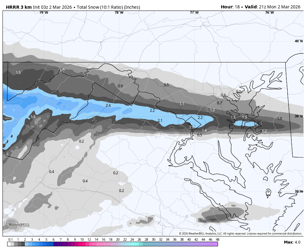
Might need it a bit further north for best results or we sleet here.. usually way overdone but even half this would be fun
.thumb.png.6301547723bfa7d9d68a0927ab8d405c.png)
-
YES!

- Today
-
-13F so far.
-

Outta gas and Outta Time: Early March Winter Storm finale
Weather Will replied to Ji's topic in Mid Atlantic
Northwest Montgomery-Central and Southeast Montgomery-Northwest Howard-Central and Southeast Howard-Western Garrett-Rappahannock- Culpeper-Fairfax-Northern Fauquier-Southern Fauquier-Western Loudoun-Eastern Loudoun-Northwest Prince William-Central and Southeast Prince William/Manassas/Manassas Park- 226 AM EST Mon Mar 2 2026 ...WINTER WEATHER ADVISORY IN EFFECT FROM 10 PM THIS EVENING TO 10 AM EST TUESDAY... * WHAT...Mixed precipitation expected. Total snow accumulations up to one inch and ice accumulations up to one tenth of an inch. * WHERE...Portions of central and western Maryland and northern and northwest Virginia. * WHEN...From 10 PM this evening to 10 AM EST Tuesday. * IMPACTS...Plan on slippery road conditions. The hazardous conditions could impact the Tuesday morning commute. * ADDITIONAL DETAILS...Some locations may see up to an inch of snow between late morning and late afternoon today, but roadway impacts should be limited. The primary threat to travel will be overnight from a wintry mix, which could briefly be snow or sleet but primarily fall as freezing rain. Precipitation will change to plain rain by mid morning Tuesday. -
Outta gas and Outta Time: Early March Winter Storm finale
Weather Will replied to Ji's topic in Mid Atlantic
Washington-Frederick MD-Extreme Western Allegany-Central and Eastern Allegany-Eastern Garrett-Morgan-Berkeley-Jefferson- Western Mineral-Eastern Mineral- 226 AM EST Mon Mar 2 2026 ...WINTER WEATHER ADVISORY IN EFFECT FROM 10 PM THIS EVENING TO 1 PM EST TUESDAY... * WHAT...Mixed precipitation expected. Total snow accumulations up to one inch and ice accumulations up to two tenths of an inch. * WHERE...Portions of north central and western Maryland and eastern West Virginia. * WHEN...From 10 PM this evening to 1 PM EST Tuesday. * IMPACTS...Plan on slippery road conditions. The hazardous conditions could impact the Tuesday morning commute. * ADDITIONAL DETAILS...Some locations may see up to an inch of snow between late morning and mid afternoon today, but roadway impacts should be limited. The primary threat to travel will be overnight from a wintry mix, which could briefly be snow or sleet but primarily fall as freezing rain. Precipitation will change to plain rain by midday Tuesday. -

Outta gas and Outta Time: Early March Winter Storm finale
yoda replied to Ji's topic in Mid Atlantic
I am kind of surprised though not to see WWAs. They have been mentioning ice in the zones for a bit now... up to a tenth of an inch. I thought even a glaze brought out WWA criteria -

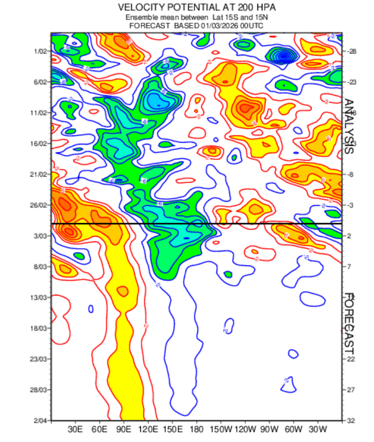
2026-2027 El Nino
jaxjagman replied to Stormchaserchuck1's topic in Weather Forecasting and Discussion
The MJO seemingly is gonna be stuck into the WP which could be for much of March from the Rossby Wave Train,this should help NINA stay alive for the next few weeks anyways
-
.thumb.JPG.418e8a9a2902ae687ec35ff4bc0e038e.JPG)
Outta gas and Outta Time: Early March Winter Storm finale
katabatic replied to Ji's topic in Mid Atlantic
I just drove back home from Richmond tonight and noticed the brining. I travel this route (259 to 48) probably 15-20 times a year and don't remember ever seeing them brined like that. -
Ugh-rude awakening upon our return from south FL tomorrow night Although I did return for the blizzard) for 3 days). Either way, your own bed always wins.
-

Outta gas and Outta Time: Early March Winter Storm finale
stormtracker replied to Ji's topic in Mid Atlantic
Sorry to hear about your dad dude. And don’t worry, we’re paying attention but prob won’t see much out of this. -

Outta gas and Outta Time: Early March Winter Storm finale
jayyy replied to Ji's topic in Mid Atlantic
I’m up in New York visiting my dad - he’s unfortunately very sick. I’ve been up here since the big storm cleared out last week. 3” also fell the 2-3 days following the blizzard. Back home in Maryland WOULD last minute luck into some accumulating snow (in early march) while I’m not there. Book it. The GFS / SREF CONTROL score a coup and someone sees 4”. Prob my backyard. My dad says you’re welcome, weenies. All jokes aside… hope y’all get one last beautiful look at winter. Enjoy it for me -
Son of a bdcf!
-
100 percent prefer the mountains , but a occasional night on the coast in a oceanfront hotel can't be beat.... Hardly anybody around tonight down here in VA Beach. Very peaceful & quiet in the off season...Balcony door open with the sounds of the crashing waves , lights of passing ships in the distance , some cheap whiskey.........................
-
Outta gas and Outta Time: Early March Winter Storm finale
stormtracker replied to Ji's topic in Mid Atlantic
Can’t wait to see pretty flakes flash melting on contact. -

Outta gas and Outta Time: Early March Winter Storm finale
87storms replied to Ji's topic in Mid Atlantic
I don’t want to steal snow from Reagan and Dulles. I’m actually rooting for them to score for the snowfall contest. -

Outta gas and Outta Time: Early March Winter Storm finale
NorthArlington101 replied to Ji's topic in Mid Atlantic
Perfect placement here. Just needs to hold for a few more hours.
-
I think you just need to expand your hiking weather. Next to no one is out on our April to June perfect track gulf soakers which provides a really cool vibe. Additionally, some trails have next to no one on them at anytime for some reason. Personally, I plan to fully use this time period before bugs and yellow jackets infest the trails.
-
Wow, I just came across this article published by the Martha's Vineyard Times which states that they measured 38" in the parking lot of TCI Press printing company in my town. Extremely impressive to say the least. I wonder why that one never made it into the snow reports? https://www.mvtimes.com/2026/02/26/delivered-news-great-blizzard-26/
-
You know we're done with winter when our March write up is on severe weather
-

Outta gas and Outta Time: Early March Winter Storm finale
SnowenOutThere replied to Ji's topic in Mid Atlantic
Some models have it better than others. Though enough show something of that sort where I'm cautiously hopeful. Don't really know where this lift is coming from but GFS and mesos show some 850-700mb temp advection and resulting FGEN which I guess will be something to watch tomorrow. I'm trying to finish my Modern Political Theory essay on Hobbes from home tomorrow ("spring" break) so some nice ambiance would be cool. -
Fired


.png.31209fbca09735542165eb10d6c87cdb.png)