All Activity
- Past hour
-

July 2025 Obs/Disco ... possible historic month for heat
Typhoon Tip replied to Typhoon Tip's topic in New England
I'm a little leery of the cooler August ideas ... unless that's changed. I see the cool-down as being typically oversold by longer range models then fading into Act III .... then we break back It's just my personal sense of where this is going. Those pesky non-linear aspects ( trend and trend' ) keep trying to lower heights in the Pac NW as kind of rest state and every time we deflate the eastern ridge, that tends to force it back. So right now the linear structures happen to look autumnal but I'd like to wait that out and see -

July 2025 Obs/Disco ... possible historic month for heat
CoastalWx replied to Typhoon Tip's topic in New England
Kind of funny comparing height anomalies on the EPS from a week ago. Poor Moregarbage -
July 2025 Obs/Disco ... possible historic month for heat
Typhoon Tip replied to Typhoon Tip's topic in New England
mine was flopping 101 ... 100 -

July 2025 Discussion-OBS - seasonable summer variability
Sundog replied to wdrag's topic in New York City Metro
I guess some type of sea breeze has overtaken the area because I'm down to 92 degrees. -

July 2025 Obs/Disco ... possible historic month for heat
RUNNAWAYICEBERG replied to Typhoon Tip's topic in New England
A Ghost town at my local park. -
.thumb.png.4150b06c63a21f61052e47a612bf1818.png)
July 2025 Obs/Disco ... possible historic month for heat
HIPPYVALLEY replied to Typhoon Tip's topic in New England
-
High of 87, so we busted yesterday and today on hitting 90. A bit less humid today but still very warm.
-
July 2025 Obs/Disco ... possible historic month for heat
HIPPYVALLEY replied to Typhoon Tip's topic in New England
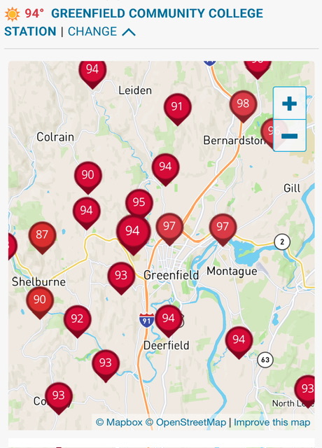
Might be first place for Greenfield. we had a lot of cloud interference with the earlier heat waves this summer. -

July 2025 Obs/Disco ... possible historic month for heat
DavisStraight replied to Typhoon Tip's topic in New England
92/76 back in Mass, always feels cooler near the shore. -

July 2025 Obs/Disco ... possible historic month for heat
kdxken replied to Typhoon Tip's topic in New England
One saving grace. -
And Sunday was forecast at 83 or so.
-

July 2025 Obs/Disco ... possible historic month for heat
dendrite replied to Typhoon Tip's topic in New England
PVD with a record as well -

2025-2026 ENSO
PhiEaglesfan712 replied to 40/70 Benchmark's topic in Weather Forecasting and Discussion
The JRA-3Q dataset is not updated for June 2025 so the MEI V2 will be late this month. -

July 2025 Obs/Disco ... possible historic month for heat
Chrisrotary12 replied to Typhoon Tip's topic in New England
No. This blows. At least it’s not Dewey. -

July 2025 Discussion-OBS - seasonable summer variability
steve392 replied to wdrag's topic in New York City Metro
Hit 100 in Paramus a little while ago! -
July 2025 Obs/Disco ... possible historic month for heat
kdxken replied to Typhoon Tip's topic in New England
Oh sure, it's accurate as all get out when it suits your agenda. -
July 2025 Obs/Disco ... possible historic month for heat
CoastalWx replied to Typhoon Tip's topic in New England
95 here for the high. -

July 2025 Obs/Disco ... possible historic month for heat
512high replied to Typhoon Tip's topic in New England
Not everyone ! Home Davis hit 97F. -

July 2025 Discussion-OBS - seasonable summer variability
SI Mailman replied to wdrag's topic in New York City Metro
101/75 here. -

2025 Lawns & Gardens Thread. Making Lawns Great Again
SouthCoastMA replied to Damage In Tolland's topic in New England
what lawns without irrigation feel like this week -
July 2025 Obs/Disco ... possible historic month for heat
dendrite replied to Typhoon Tip's topic in New England
MHT 100! -

July 2025 Discussion-OBS - seasonable summer variability
LibertyBell replied to wdrag's topic in New York City Metro
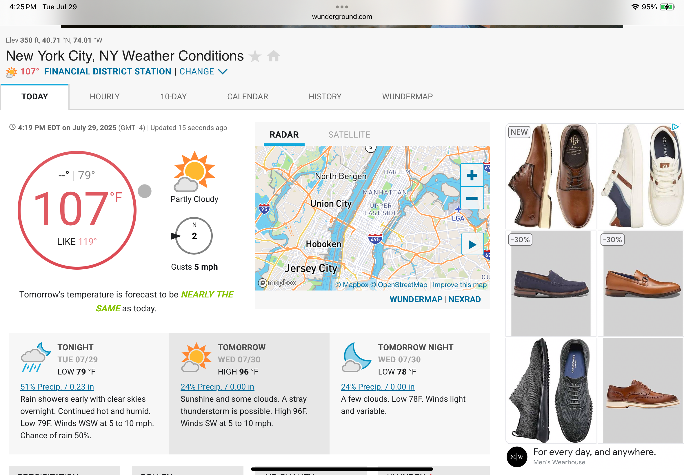
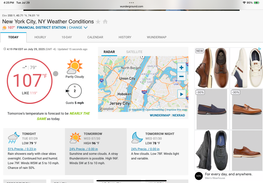
dew points in the mid to upper 60s not that bad The highs around the region so far EWR 100 LGA 100 NYC 97 JFK 96 - Today
-

July 2025 Discussion-OBS - seasonable summer variability
TriPol replied to wdrag's topic in New York City Metro
-
You guys some get some numerous showers and thunderstorms with the upslope flow. There is a flash flood watch for Colorado Springs. The GFS predicts up to 2" in Weld County in the next two days.
-

July 2025 Obs/Disco ... possible historic month for heat
Damage In Tolland replied to Typhoon Tip's topic in New England
Everyone everywhere is so happy. Good times