All Activity
- Past hour
-

Possible Record Breaking Cold + Snow Sunday 1/25 - Tuesday 1/27
MJO812 replied to TriPol's topic in New York City Metro
Nam jumps around alot. Thats why people ignore it. I do agree with you though. -
The RAP gives me around 4-5 inches, plus lots of sleet and zr. It has the 1.5 inches of snow line down to 40 in Knoxville.
-
Got it, thanks
-
Mount Holly going pretty aggressive here with the snow. Quite a range though so they cover their ass lol. 3-7 tomorrow night and 4-8 Sunday,
-

“Cory’s in LA! Let’s MECS!” Jan. 24-26 Disco
moneypitmike replied to TheSnowman's topic in New England
It's a Norfolk/Plymouth oounty kind of winter on the 06 GFS. -
That seems lazy if true, not saying it is. If you look at the skew on the euro it’s clear their algorithm is just wrong and misidentifying p type. It does have some legit freezing rain for you but it also is showing freezing rain for hours where there is a warm layer above 800mb and it’s like 22 at the surface. Thats sleet.
-
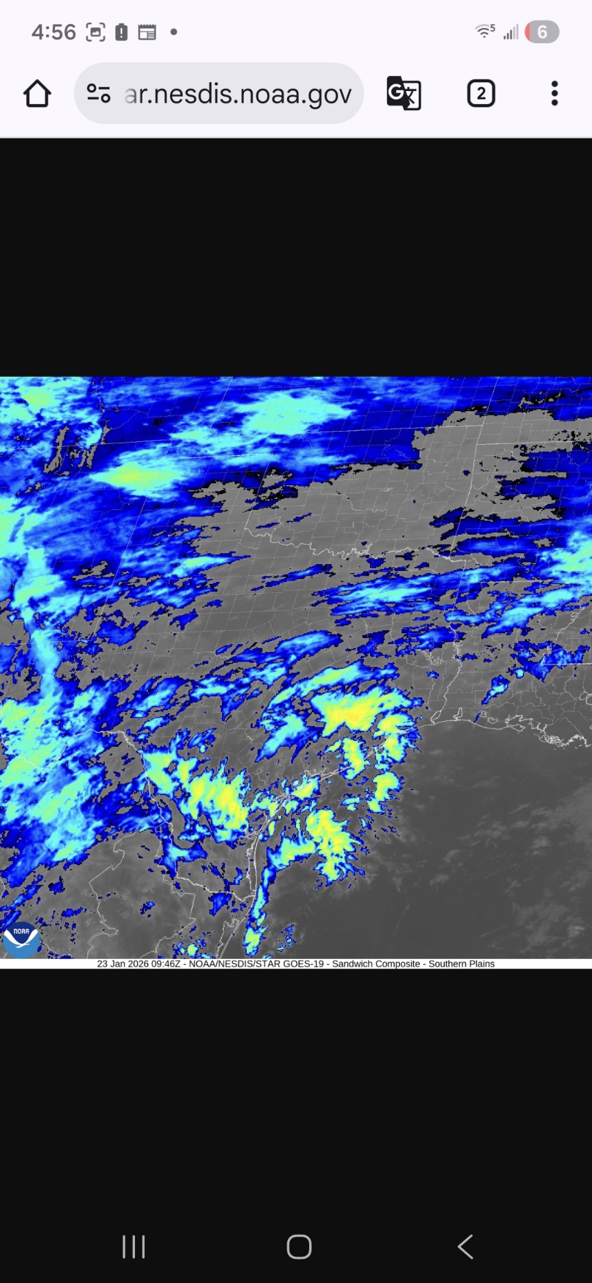
.thumb.jpg.6a4895b2a43f87359e4e7d04a6fa0d14.jpg)
Central PA Winter 25/26 Discussion and Obs
Yardstickgozinya replied to MAG5035's topic in Upstate New York/Pennsylvania
This is where I start getting giddy, quantifiable images. The gods are bowling
-
Sorry, meant 25%. iow, use 75% of gfs values
-
75%?
-
If you look at the euro or 3k skew for the same time its surface temp is within 1 degree. The problem is the gfs cannot see the warm layer at 750mb. It’s not capable of it. This is a known problem. In cases where there is WAA and a mid level warm layer you have to adjust the snow/sleet line NW on the gfs. You can figure out where it should be a number of ways. Least technical is to look at the 3k or euro and say ok now if their Synoptics were identical to the gfs where would they have the snow/sleet line? Then make the adjustment. If you use the GFS snow line in wAA situations you’ll be wrong EVERY SINGLE TIME. It won’t ever see the mid level warming. Caveat…the only way we overcome the mid levels is if the precip is so heavy (death banded) that dynamic cooling can overcome a bit and the heavy precip can mix out the admittedly small warm layer all the better guidance has for our area. That’s not impossible but it wouldn’t be the gfs being correct it would a similar result for different reasons. like if you call a crossing route on 4th and goal from the 5 and the receiver falls down and the QB scrambles and breaks 2 tackles and dives into the end zone. Sure it ended up with a TD, same results, but when breaking it down in film study you wouldn’t say the play worked.
-
Possible Record Breaking Cold + Snow Sunday 1/25 - Tuesday 1/27
MJO812 replied to TriPol's topic in New York City Metro
Yep just expect 6-12 for the metro. Still a good storm . Once again the mid levels are ruining it for us. It all depends how fast the sleet comes in. The later the better. Who knows , maybe it will the models will be wrong and never turns to sleet. It has happen before. -

Possible Record Breaking Cold + Snow Sunday 1/25 - Tuesday 1/27
Tatamy replied to TriPol's topic in New York City Metro
Snowman - Totally agree. I am following the RDPS closely as that is another good Meso.
-
“Cory’s in LA! Let’s MECS!” Jan. 24-26 Disco
moneypitmike replied to TheSnowman's topic in New England
Just saw it and laugh......that 5" is a killer! I'd typically be thrilled with what we're getting......but when there's so much opportunity a mere 50-75 miles south, it's disappointing. I'll give 12z or 18z to show a tease of moving north. I think it's pretty locked at this point though. -
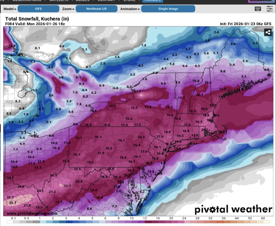
6z AI GFS has a Monster Winter Storm next weekend
-

Central PA Winter 25/26 Discussion and Obs
MickeyTim6533 replied to MAG5035's topic in Upstate New York/Pennsylvania
so the storm is over by Sunday night? seems quick -

Possible Record Breaking Cold + Snow Sunday 1/25 - Tuesday 1/27
SnoSki14 replied to TriPol's topic in New York City Metro
Once it gets under 48hrs we'll pay attention. Even so it still has the 6-8" front end dump before any changeover. That's pretty much the floor with this. -
Possible Record Breaking Cold + Snow Sunday 1/25 - Tuesday 1/27
Tatamy replied to TriPol's topic in New York City Metro
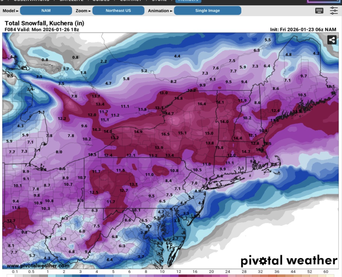
06z GFS
-
Central PA Winter 25/26 Discussion and Obs
Yardstickgozinya replied to MAG5035's topic in Upstate New York/Pennsylvania
She's starting to come together.


-
Possible Record Breaking Cold + Snow Sunday 1/25 - Tuesday 1/27
SnoSki14 replied to TriPol's topic in New York City Metro
Yeah GFS held or even ticked a bit colder. Rgem was colder, Icon too. Nam still drops 6-8" before any flip. -

Possible Record Breaking Cold + Snow Sunday 1/25 - Tuesday 1/27
snowman19 replied to TriPol's topic in New York City Metro
When the NAM shows a midlevel warm nose, definitely believe it. That’s literally the ONLY thing it’s good for and it has been schooling all the global models and the other meso models for years with it. It is a huge mistake to write off the NAM when it shows a warm nose. People have been burned time and time again when they ignore it -
It gives me 15". I would be very happy if I received half of that total. The 06z NAM gives me no snow, but 1.5" of ZR. Who knows what's going to happen at this point.
-
Just catching up. So the gfs didn’t fully cave, but pretty much all guidance met in the middle. I’d cut gfs accums by 75% though to account for ip/zr. That gets us to 6-10 for dc/balt metros, with a foot being in play for NW suburbs (1-2 counties off from I-95 and north of 50)
-
Likewise. Yeah it's closer to its 18z solution. We can still benefit from ticks esp considering we're not escaping without ZR.
-
Mt Holly only mentions snow and freezing rain in the forecast for here- no mention of sleet. Maybe they are taking the Euro verbatim with its freezing rain output. GFS has more significant sleet and less amounts of zr.
-

Central PA Winter 25/26 Discussion and Obs
pasnownut replied to MAG5035's topic in Upstate New York/Pennsylvania
0z euro also looks better. Still has us SE'rs pingin for a bit, but pops secondary a tad quicker. Theres not a model I wouldnt sign for. NMB's snow maps gotta look great right now.