All Activity
- Past hour
-

E PA/NJ/DE Autumn 2026 Obs/Discussion
JTA66 replied to PhiEaglesfan712's topic in Philadelphia Region
Looks like the AC goes back on for a few days. 83F/DP 69F -
 mail order mexican pharmacy: MexicoGenerics :: mexico pharmacy order online birth control
 -
https://mexicogenerics.shop/# best online pharmacies in mexico
-
2018 looks like the early leader in the clubhouse.
-
Pretty content with the 0.92" that fell here.
-
Time to start compiling a sensible weather analog composite....last one prior to the outlook.
-

2026-2027 Record-breaking El Nino
LakePaste25 replied to Stormchaserchuck1's topic in Weather Forecasting and Discussion
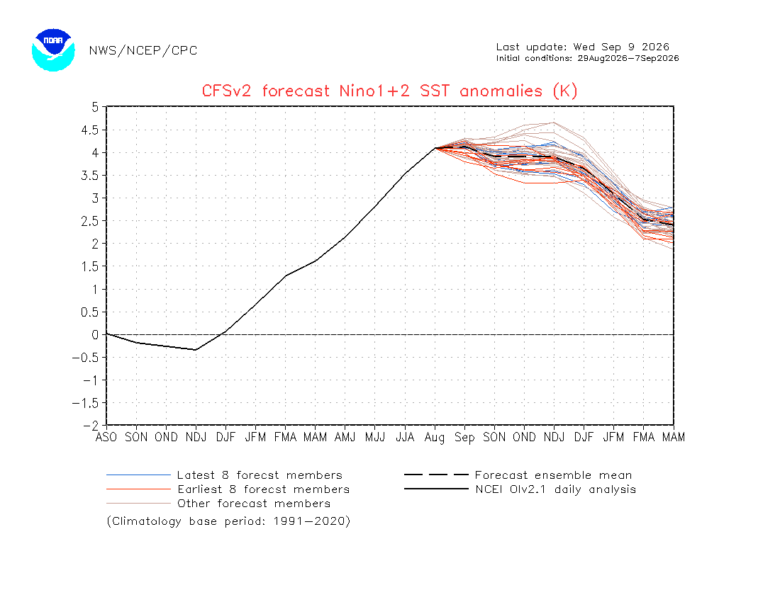
Yup. It’s consistent with it undershooting 1+2 -
I mean all you have to do is look at previous strong EL Nino episodes...they all (I'd presume) had very low ACE seasons. The EL Nino's of 1982-1983 and 1997-1998 only had seasonal numbers in the single digits. 2015-2016 I think was a bit higher but still below the climatological average
-
Any insight as to potential windows that are less hostile for the east coast?
-

Septorcher 2026 Discussion - Endless Summer
forkyfork replied to Damage In Tolland's topic in New England
and now the country is being burned to the ground. haha -

Septorcher 2026 Discussion - Endless Summer
tamarack replied to Damage In Tolland's topic in New England
Many of those millions were voting against HRC, Biden and Kamala more than voting for Trump. -
September 9 1979: 1 3/4 inch hail falls in Douglas County. 1917: Very chilly air moves into Minnesota, with a low of 17 degrees at Roseau. For Wednesday, September 9, 2026 1921 - A dying tropical depression unloaded 38.2 inches of rain upon the town of Thrall in southeastern Texas killing 224 persons. 36.4 inches fell in 18 hours. (David Ludlum) (The Weather Channel) 1944 - The ""Great Atlantic Hurricane"" ravaged the east coast. The storm killed 22 persons and caused 63 million dollars damage in the Chesapeake Bay area, then besieged New England killing 390 persons and causing another 100 million dollars damage. (The Weather Channel) 1971 - Hurricane Ginger formed, and remained a hurricane until the 5th of October. The 27 day life span was the longest of record for any hurricane in the North Atlantic Ocean. (The Weather Channel) 1987 - Thunderstorms produced severe weather in the central U.S. Thunderstorms in West Texas spawned four tornadoes in the vicinity of Lubbock, and produced baseball size hail and wind gusts to 81 mph at Ropesville. Thunderstorms produced hail two inches in diameter at Downs KS and Harvard NE, breaking car windows at Harvard. (The National Weather Summary) (Storm Data) 1988 - Florence became a hurricane and headed for the Central Gulf Coast Region. Florence made landfall early the next morning, passing over New Orleans LA. Winds gusts to 80 mph were recorded at an oil rig south of the Chandeleur Islands. Wind gusts around New Orleans reached 61 mph. Total property damage from Florence was estimated at 2.5 million dollars. (Storm Data) (The National Weather Summary) 1989 - The first snow of the season began to whiten the mountains of Wyoming early in the morning, as for two days a moist and unusually cold storm system affected the state. By the morning of the 11th, a foot of snow covered the ground at Burgess Junction. Thunderstorms developing along a cold front crossing the Ohio Valley produced severe weather in Indiana during the late afternoon and early evening hours. Strong thunderstorm winds blew down a tent at Palestine injuring seven persons, and frequent lightning interrupted the Purdue and Miami of Ohio football game, clearing the stands. (The National Weather Summary) (Storm Data) Observances: 9 Wed International Sudoku Day 9 Wed International Day to Protect Education from Attack 9 Wed California Admission Day 9 Wed National Teddy Bear Day 9 Wed Care Bears Share Your Care Day 9 Wed International Box Wine Day 9 Wed International Fetal Alcohol Spectrum Disorders Awareness Day 9 Wed National When Pigs Fly Day 9 Wed National Wiener Schnitzel Day 9 Wed Steak Au Poivre Day 9 Wed Teddy Bear Day 9 Wed Wonderful Weirdos Day
-
indian pharmacy reviews: India Generic Store : rx india online shopping
-
i am so powerful people make whole new accounts just to respond to me
-

2026-2027 Record-breaking El Nino
40/70 Benchmark replied to Stormchaserchuck1's topic in Weather Forecasting and Discussion
Makes sense since the drop is due to the El Nino being focused east of 3.4 right now, rather then any type of reduced expression of El Nino across the hemisphere - Today
-

2026-2027 Record-breaking El Nino
GaWx replied to Stormchaserchuck1's topic in Weather Forecasting and Discussion
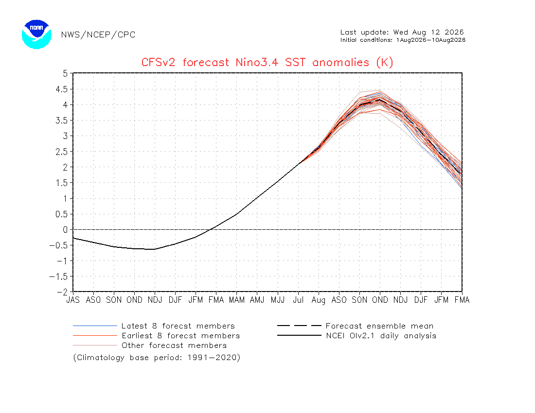
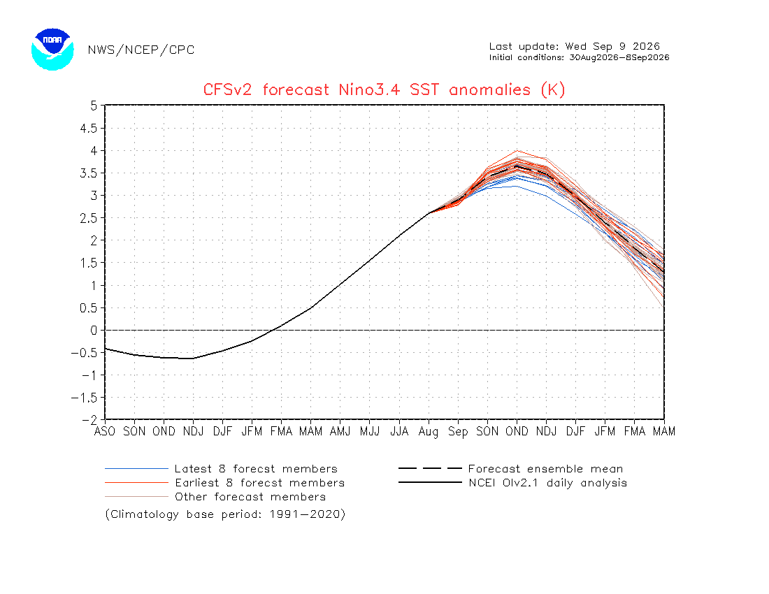
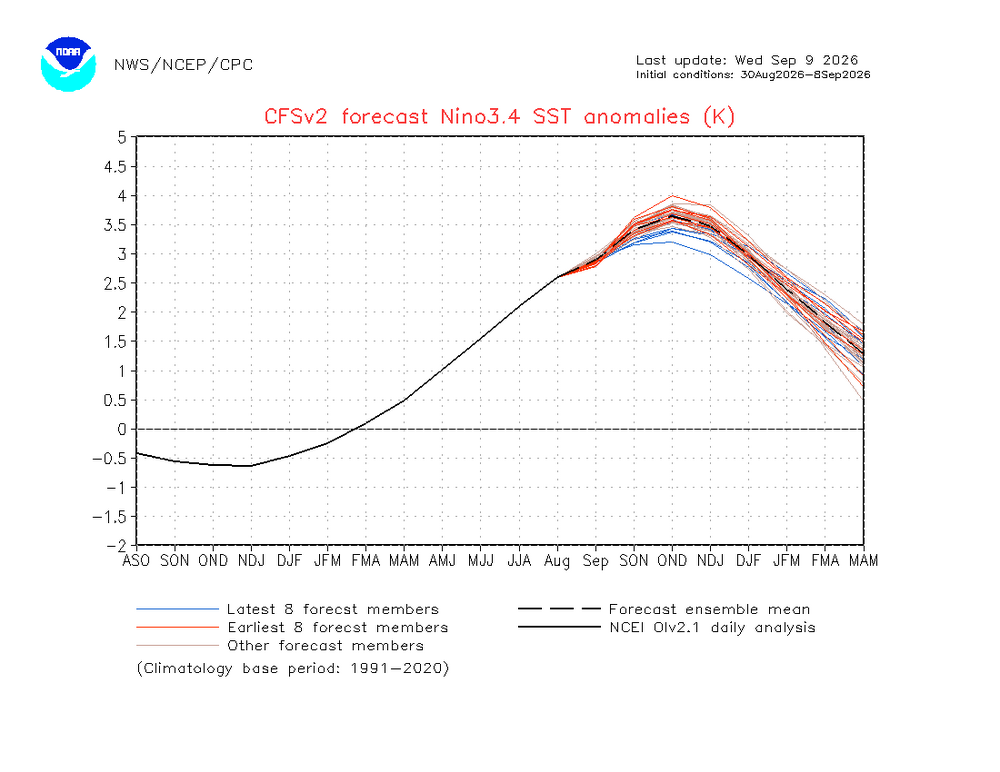
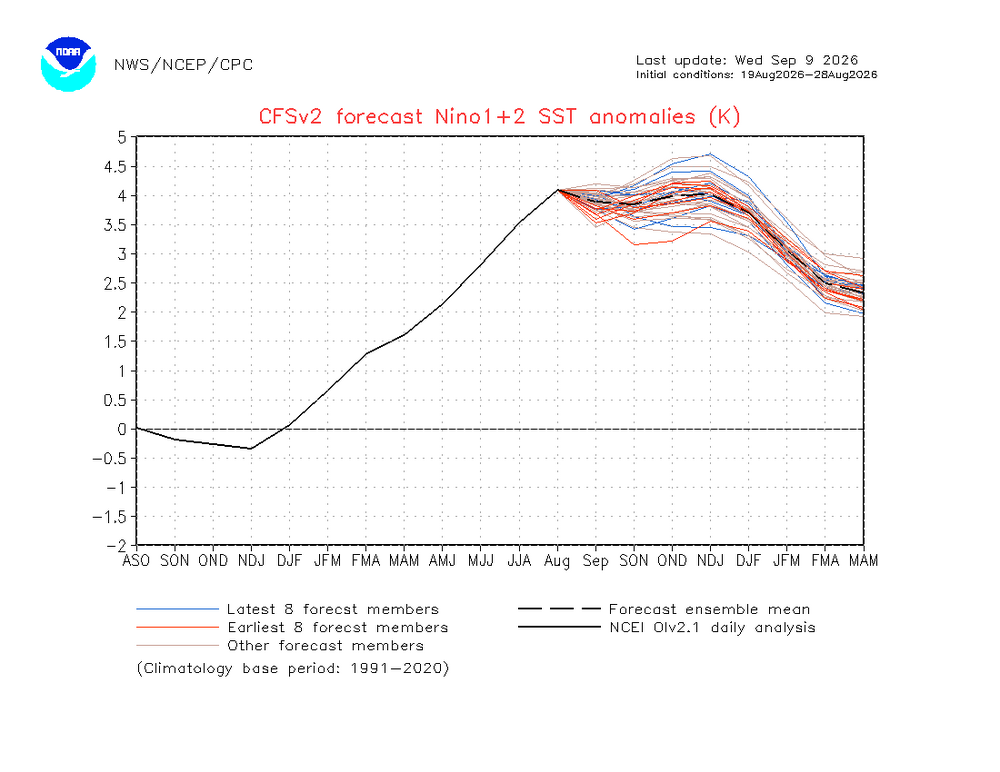
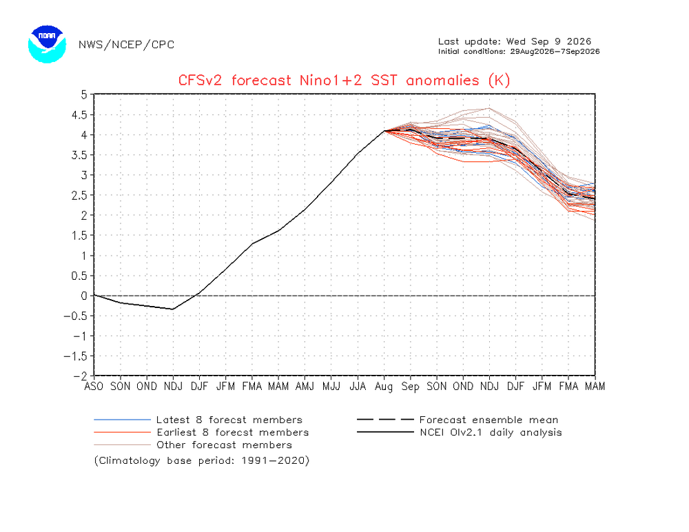
The ONI peak in OND fell by the same 0.5 over the same period: Aug 1-10: ONI peak +4.15 Aug 30-Sep 8: ONI peak +3.65 and likely to fall further just like RONI as per the location of the blue lines So, the difference between the peaks of ONI and RONI didn’t widen.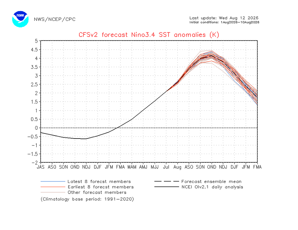
-
gas up the snowblowers folks
-

Septorcher 2026 Discussion - Endless Summer
Snowedin replied to Damage In Tolland's topic in New England
Meh by early-mid swamptober, we’ll be back to our usual deluges thanks to screaming nor’easters and stalled out lows by the Great Lakes. Embrace the relative calm before bratty kids and their bewildered parents are nearly blown away by another pre Halloween torch cyclone! -
2026-2027 Record-breaking El Nino
GaWx replied to Stormchaserchuck1's topic in Weather Forecasting and Discussion
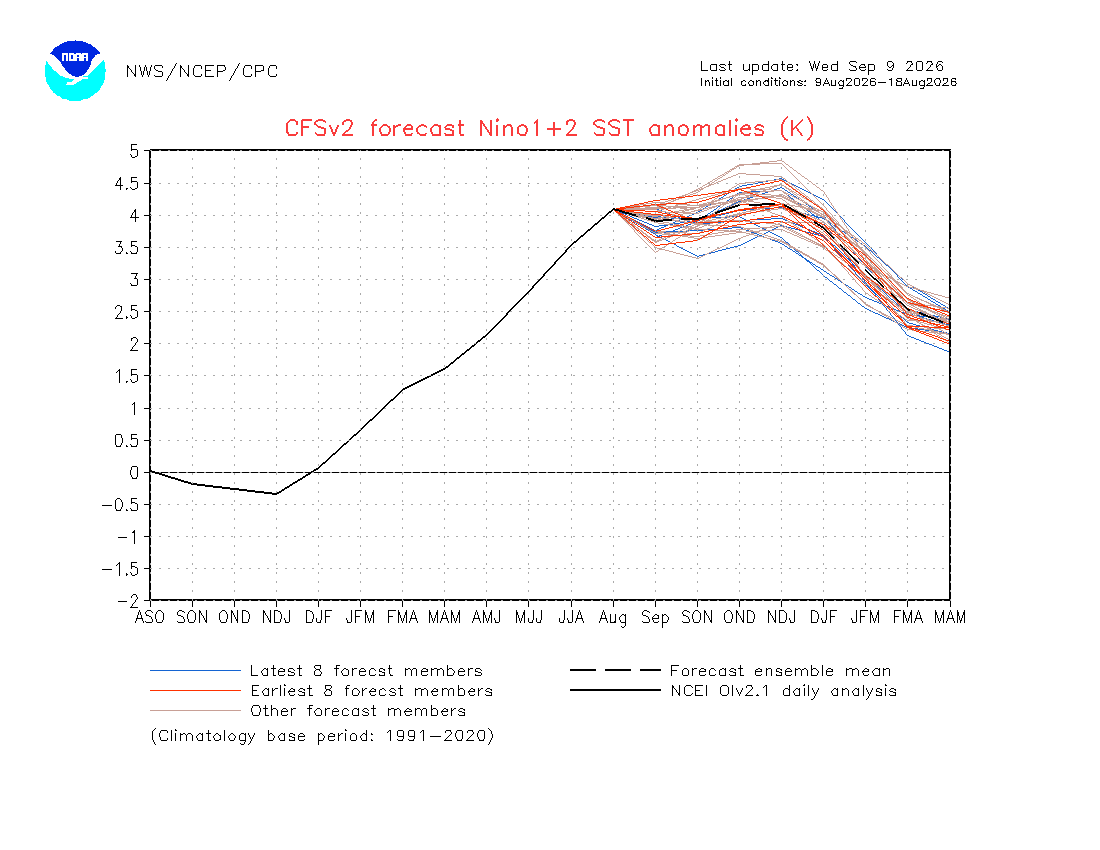
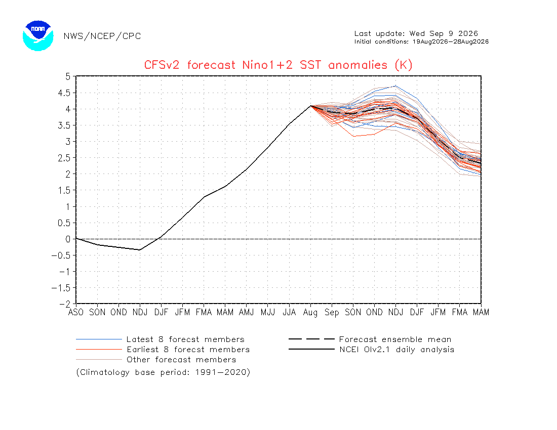
I know ‘26 became the most E based of any Nino on record in early Sep as I posted here 2 days ago: Although 1+2 has warmed in Sep, it like RONI has also fallen in OND fwiw though by not as much (0.3 vs 0.5) making it slightly more E based in OND than it had before: Aug 9-18: 1+2 OND +4.2 Aug 19-28: 1+2 OND +4.0 Aug 29-Sep 7: 1+2 OND +3.9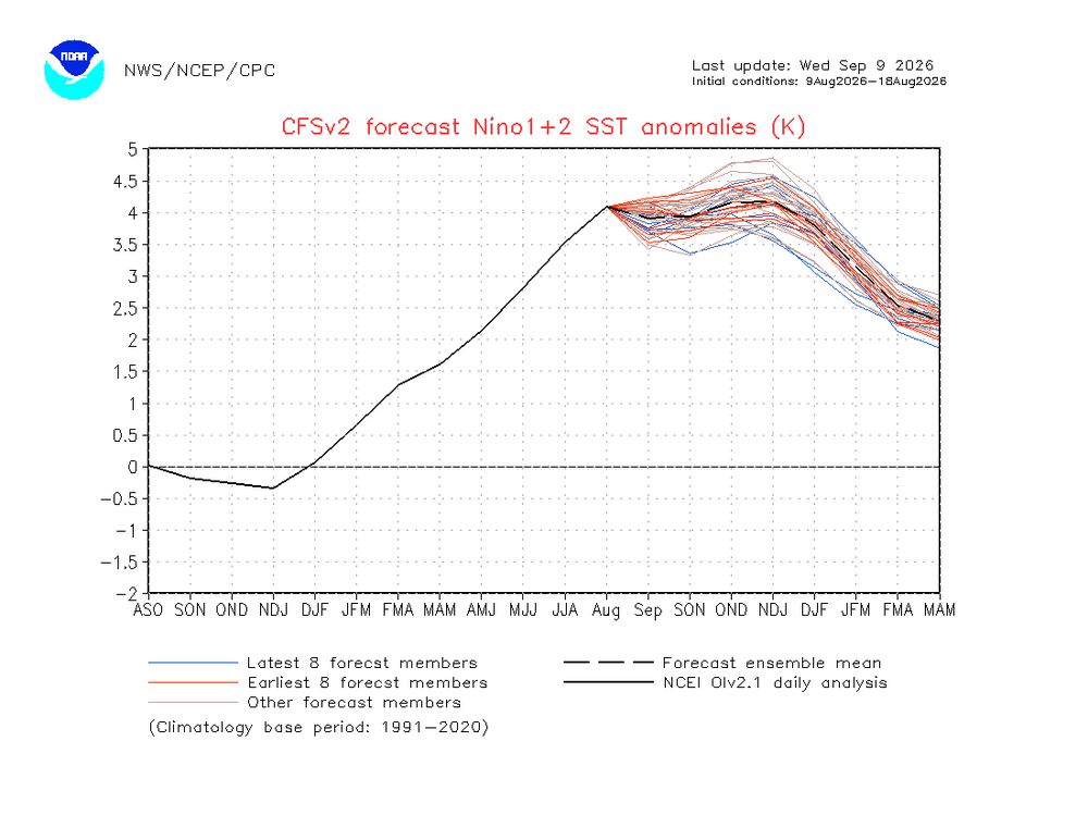
-
(002).thumb.png.6e3d9d46bca5fe41aab7a74871dd8af8.png)
Central PA Summer 2026 Discussion/Obs Thread
ChescoWx replied to Voyager's topic in Upstate New York/Pennsylvania
Thanks to requests I have one more add to the chescowx.com website. It now includes a current weather tab with current conditions at East Nantmeal along with the current 10-day East Nantmeal ChescoWx forecast system and a forecast verification scoring comparison to the current National Weather Service forecast. Along with a breakdown of models used by % for the ChescoWx forecast. Of note ChescoWx has been scored better on 13 of the first 14 days of review to date. https://chescowx.com/current-weather/ -
E PA/NJ/DE Autumn 2026 Obs/Discussion
ChescoWx replied to PhiEaglesfan712's topic in Philadelphia Region
Thanks to requests I have one more add to the chescowx.com website. It now includes a current weather tab with current conditions at East Nantmeal along with the current 10-day East Nantmeal ChescoWx forecast system and a forecast verification scoring comparison to the current National Weather Service forecast. Along with a breakdown of models used by % for the ChescoWx forecast. Of note ChescoWx has been scored better on 13 of the first 14 days of review to date. https://chescowx.com/current-weather/ -
Latest in the season overnight low of < 60 F for central park? No < 60 F overnight lows forecast for the next 10 days at least which has to be a record? Dews too high these days.
-
.thumb.gif.f92b16c631a1d15d405ed77b33f0710d.gif)
Septorcher 2026 Discussion - Endless Summer
Torch Tiger replied to Damage In Tolland's topic in New England
Smoothed anomalies, I expect like 60% -

Septorcher 2026 Discussion - Endless Summer
FXWX replied to Damage In Tolland's topic in New England
I'm ok with that... Overall a great early fall Goldilocks pattern; not too warm; not too cold, not too wet and not too dry... Certainly not extreme... A little boring for sure but with the likelihood of an active East Coast winter, I'm ok with boring right now... -
NFL pick em pool is up in the sports thread! Get your picks in