All Activity
- Past hour
-

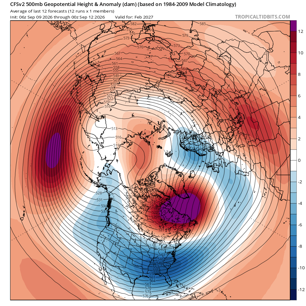
2026-2027 Record-breaking El Nino
mitchnick replied to Stormchaserchuck1's topic in Weather Forecasting and Discussion
Flurries for you -

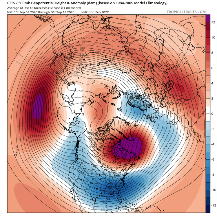
2026-2027 Record-breaking El Nino
GaWx replied to Stormchaserchuck1's topic in Weather Forecasting and Discussion
-

Septorcher 2026 Discussion - Endless Summer
CoastalWx replied to Damage In Tolland's topic in New England
Endless Autumn? -
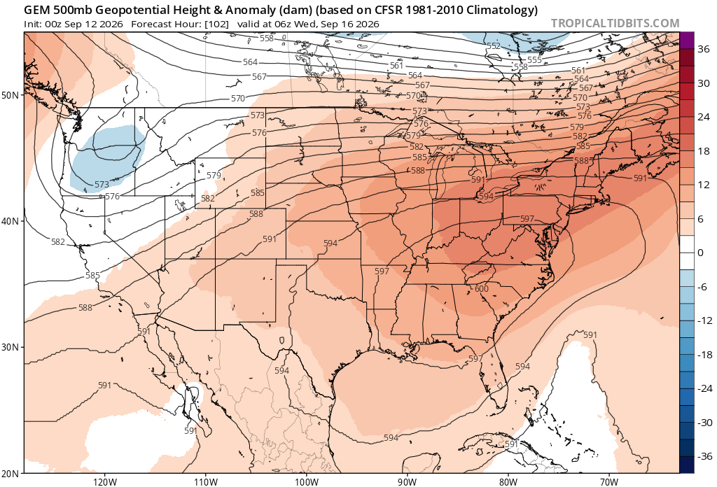
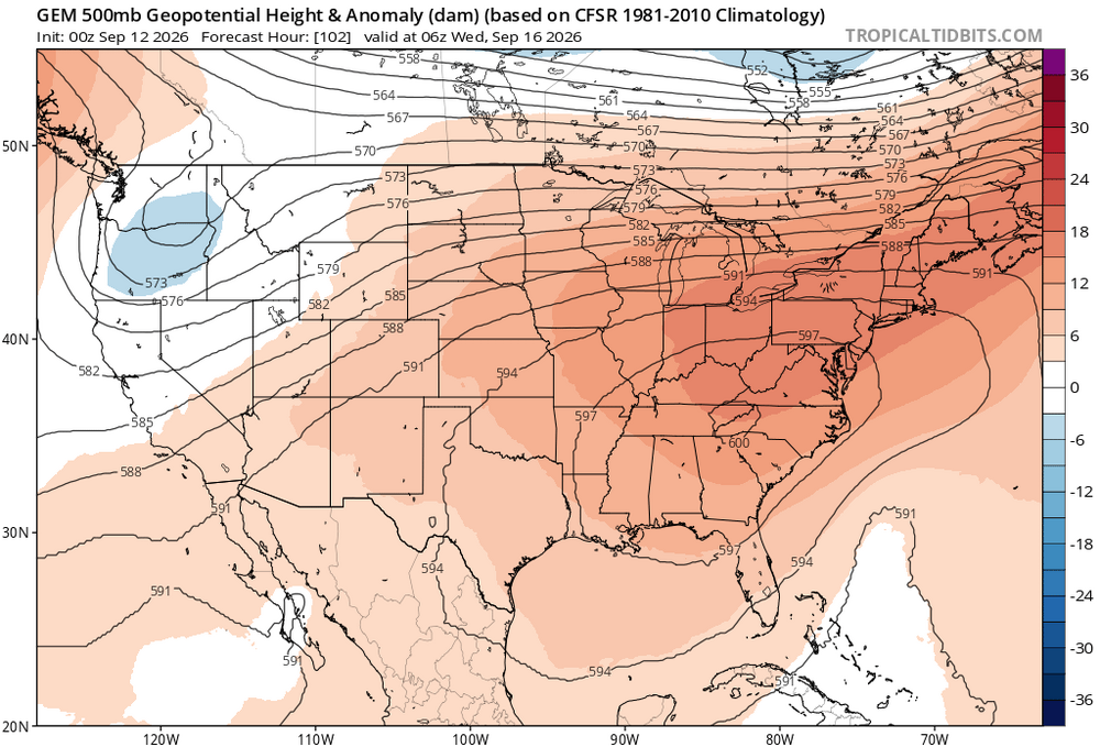
Probably more mid 80s to perhaps around 90° by later next week at the usual warm spots. So a continuation of the endless summer pattern. Really impressive to see a near 600 dm ridge in September. Very difficult to get any sustained fall cooldowns beyond 3-4 days with such strong ridges.
-

Septorcher 2026 Discussion - Endless Summer
Damage In Tolland replied to Damage In Tolland's topic in New England
Our weather this winter will feel like we’re somewhere over Laredo it seems -
And, memorably, in January 1998. Weirdest, most unpleasant January day ever. It felt kind of like this morning does: gloomy, stifling and overcast.
-
Yeah it’s been rising quite a bit. Neutral-ish now
-
Dec. 14th
-

Occasional Thoughts on Climate Change
LibertyBell replied to donsutherland1's topic in Climate Change
Since I'm in Pennsylvania I've dug up some records. July 1936 isn't the one you should be looking at it's July 1911. The progenitor of the 11 year cycle super hot summers with some amazing heat records in the Poconos that have not been matched since and probably will never be. Climate change may increase the average temperatures but we do not get record high temperatures like that anymore. Climate change is strictly minimum driven in this part of the country. Summer record highs are more common in the West and central part of the country. Not here. This is why I caution people not to assume that a +2 c increase in averages means the highs will increase by that much or that new heat records will be set, that's not how this works. -

Central PA Summer 2026 Discussion/Obs Thread
mahantango#1 replied to Voyager's topic in Upstate New York/Pennsylvania
Hazardous Weather Outlook National Weather Service State College PA 442 AM EDT Sat Sep 12 2026 PAZ004>006-010>012-017>019-024>028-033>037-041-042-045-046-049>053- 056>059-063>066-130900- Warren-McKean-Potter-Elk-Cameron-Northern Clinton-Clearfield- Northern Centre-Southern Centre-Cambria-Blair-Huntingdon-Mifflin- Juniata-Somerset-Bedford-Fulton-Franklin-Tioga-Northern Lycoming- Sullivan-Southern Clinton-Southern Lycoming-Union-Snyder-Montour- Northumberland-Columbia-Perry-Dauphin-Schuylkill-Lebanon-Cumberland- Adams-York-Lancaster- 442 AM EDT Sat Sep 12 2026 This Hazardous Weather Outlook is for central Pennsylvania. .DAY ONE...Today and tonight. There is a chance for showers and storms later this afternoon into early Sunday that could result in ponding of water on roads and localized flooding. Strong winds will also be possible. .DAYS TWO THROUGH SEVEN...Sunday through Friday. There is chance for strong to severe storms Sunday afternoon into the evening hours. .SPOTTER INFORMATION STATEMENT... Spotters are encouraged to report significant hazardous weather. -
-
Probably nothing like what we had around this date in 1983. Did you check the records from 1983? That truly was the 4 month endless summer. June. July. August. September lol. The only other summers I can think of that were endless like that were 1991, 1993 and 2010. 2002 was very good too but I think that one ended in August like 1999 did. This summer has really been near normal. Each month has been hot in the first half and cool in the second half.
- Today
-
Central PA Summer 2026 Discussion/Obs Thread
mahantango#1 replied to Voyager's topic in Upstate New York/Pennsylvania
US National Weather Service State College PA Tornado #49 for PA in 2026: 972 NOUS41 KCTP 120053 PNSCTP PAZ005-120500- Public Information Statement National Weather Service State College PA 853 PM EDT Fri Sep 11 2026 ...NWS Damage Survey for 09/09/2026 Tornado Event... .Lafayette Township Tornado... Rating: EF1 Estimated Peak Wind: 105 mph Path Length /statute/: 1.23 miles Path Width /maximum/: 200 yards Fatalities: 0 Injuries: 0 Start Date: 09/09/2026 Start Time: 07:19 PM EDT Start Location: 2 WSW Cyclone / McKean County / PA Start Lat/Lon: 41.8097 / -78.6272 End Date: 09/09/2026 End Time: 07:22 PM EDT End Location: 1 WSW Cyclone / McKean County / PA End Lat/Lon: 41.8144 / -78.6054 Survey Summary: At 7:19 p.m. local time September 9, 2026 an EF-1 tornado with maximum wind speeds of 105mph touched down between Bradford Airport and Bingham Road with a maximum width of about 200 yards. It traveled east/northeast and damaged some trees around and west of Bingham Road. The tornado continued through the area of woods east of Bingham Road before doing its most intense damage along and north of Sprester Road. It uprooted and snapped many trees before flipping a trailer on its side. The tornado turned northeast and continued damaging trees into the woods before dissipating as it approached the Buffalo & Pittsburgh Railroad line around 7:22 p.m. local time. We would like to thank McKean County Emergency Management and members of the community who provided firsthand accounts, footage, and pictures of damage. && -
Septorcher 2026 Discussion - Endless Summer
CoastalWx replied to Damage In Tolland's topic in New England
Although the new RRFS 2.0 is more widespread. -
Septorcher 2026 Discussion - Endless Summer
CoastalWx replied to Damage In Tolland's topic in New England
South coast special tomorrow -
Septorcher 2026 Discussion - Endless Summer
CoastalWx replied to Damage In Tolland's topic in New England
Thankfully 53. Not ready for summer to go. We endless. -

Septorcher 2026 Discussion - Endless Summer
dendrite replied to Damage In Tolland's topic in New England
The lawn must be frosted at that temp -

Septorcher 2026 Discussion - Endless Summer
Bostonseminole replied to Damage In Tolland's topic in New England
52/50 . -

Central PA Summer 2026 Discussion/Obs Thread
pawatch replied to Voyager's topic in Upstate New York/Pennsylvania
51 degrees this morning. Been fishing and burning a lot of gas. Have about 10-15 mile run. -

Septorcher 2026 Discussion - Endless Summer
kdxken replied to Damage In Tolland's topic in New England
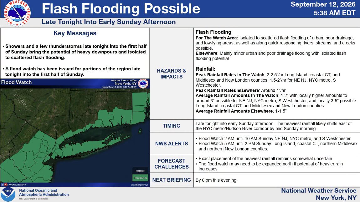
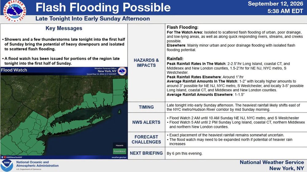
"So in a nutshell...the ingredients above are concerning for a narrow band of torrential rainfall and the potential for localized flash flooding. The HREF has probabilities for 6-24 HR precipitation values to exceed 10 year ARI across parts of eastern CT/RI and southeast MA. There are even very low probabilities to exceed 100 year ARI values near the south coast. That being said...whether or not this actually materializes remains uncertain and will depend on the mesoscale. And on top of that...even if it occurs trying to determine the specific location is still beyond the state of the science. But we do know this risk will hinge on the potential for where a mesoscale low tracks...which would setup an area of enhanced low level convergence for the southerly LLJ to impinge upon" Stein! -
Northern California has been the place to be so far for cool fall weather.

-
Septorcher 2026 Discussion - Endless Summer
kdxken replied to Damage In Tolland's topic in New England
46° coldest since June 2nd. -
Septorcher 2026 Discussion - Endless Summer
dendrite replied to Damage In Tolland's topic in New England
42.5° definitely under guidance HIE 32 and SLK 31 -

Septorcher 2026 Discussion - Endless Summer
alex replied to Damage In Tolland's topic in New England
The endless summer has ended. Currently 31.6
-
I’m not very hopeful based on this morning’s models, but maybe we get lucky.