All Activity
- Past hour
-

Junorch obs and discussion 2026
Damage In Tolland replied to Damage In Tolland's topic in New England
It’s been like this several weeks. Worse by the day -
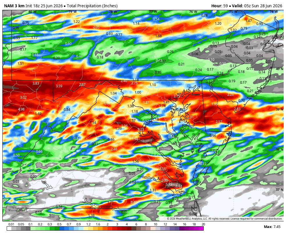
Cloudflare bad gateway 18Z says no rain on Saturday.
-
Nailed it. Mirror image of the Reflective Pool.
-
We have our best guy on it right now
-
Some of this is almost certainly the GFS doing GFS kinds of things (i.e., too hot especially after day 5). The GFS does this frequently in summer. It could easily be 5-10 F too hot. I’d bet heavily against it being this hot. Quite hot is likely but not this hot.
-
This thing is full struggle bus today.
-
Yes!!! And not done at HR 60. WB 18Z 3K NAM

-

-
In honor of the 250th anniversary of this country…we are bringing you internet speeds similar to 25.0 years ago.
-
Cansips looks wrong…but if it is correct, we would be in business. Got a feeling it changes just a bit during future runs. But I hope not.
-

E PA/NJ/DE Summer 2026 Obs/Discussion
Birds~69 replied to PhiEaglesfan712's topic in Philadelphia Region
79F/DP 62F Under 90...
-
QBO should pop positive, right? Teleconnections are iffy right now. Storm track might be marginal help. Super Nino patterns are generally warm here with a random, highly localized big snow in somebody’s backyard. Might be the MJO is our best bet with warm water over 8-2-1. It might balance out the poor QBO alignment.
-

-
@dendrite Server/VM needs to be rebooted. It doesn't appear to be a network issue. Probably some service is hogging memory or cpu.
-
With mid to upper 90s on tap next week….winter with temps in the 50s all winter doesn’t seem so bad. LOL. As for the slow down…it‘s hot and this forum doesn’t do AN temps in the summer. LOL. I figured I would go w a winter thread since the current pattern is a snoozer. It will crank up soon enough!
-
NBM which does really well on temps is mid-90s with some 97 and 98s. I was skeptical its first year or two. A mid-range high-res ensemble? Well the NBM has performed very well both winter and summer high demand weather. Guess it'll bust occasionally like anything, but I'm optimistic we can avoid widespread 100s. That said, somebody will get there. Also humidity will be atrocious. Also regardless of anything heat index 100-110 will be hazardous. We are not acclimated yet after the modest start to summer.
-
A shower or thundershower is possible tonight into early tomorrow. Afterward, tomorrow will be pleasantly warm with highs in the lower to perhaps middle 80s. Some showers are possible tomorrow night and then again Friday night or Saturday. A warming trend could commence on Sunday. The guidance increasingly suggests that hot weather could return to conclude June and start July. The ENSO Region 1+2 anomaly was +3.0°C and the Region 3.4 anomaly was +1.7°C for the week centered around June 17. For the past six weeks, the ENSO Region 1+2 anomaly has averaged +2.42°C and the ENSO Region 3.4 anomaly has averaged +1.22°C. The ongoing El Niño will continue to strengthen through the summer. The SOI was -18.28 yesterday. The preliminary Arctic Oscillation (AO) was +0.424 today. Based on sensitivity analysis applied to the latest guidance, there is an implied near 94% probability that New York City will have a warmer than normal June (1991-2020 normal). June will likely finish with a mean temperature near 73.4 (1.4° above normal). Supplemental Information: The projected mean would be 2.0° above the 1981-2010 normal monthly value.
-
East based super Nino should be warm and stormy. Agree the secondary pattern probably will be a couple weeks of Arctic dump. Loss of baroclinicty at the hemispheric level allows the jet stream to weaken, buckle, and deliver cold. Primary pattern I'm looking for mild mainly due to no cold air to deliver (outside the very meridional patterns) from the Midwest or even south-central Canada. East based is less conducive for other cold patterns. Maybe we can get southwest flow all winter. If it's not going to snow, give me severe! Might be my last post for a while. Why is the board so slow?
-
Dendrite potting Paw Paws while the website collapses. Who can we speak to?
- Today
-
Someone should make a New England version. Although Will would win every time. https://stormguessr.com/
-
Not surprisingly the NAM models shifted south on the 18z run. Saturday is looking like very little rain.
-
-
Posted this in the old thread but its dead. Impressive straight-line wind damage the Tuesday night south of me. Apparently a tractor trailer was overturned as well.
-
The 12z Euro came in looking like the GFS, or even hotter, for the lower elevations. 100+ for Nash, Knox, and Chattanooga next Saturday on it. The AI is still more in the low to mid 90s camp.
-
18z NAM says it's raining at my house right now....news to me