All Activity
- Past hour
-
Lots of lightning in view here at oriole park. Looks like the bulk of it might drop between Baltimore and Columbia.
-

July 2025 Obs/Disco ... possible historic month for heat
RUNNAWAYICEBERG replied to Typhoon Tip's topic in New England
Reach for the backside then for a slice? -

July 2025 Obs/Disco ... possible historic month for heat
Torch Tiger replied to Typhoon Tip's topic in New England
I love the HHH too, but you okay bro? -
Good quality sounding booms off to my north (from Columbia). Also some building cumulus at sunset in N&NW skies. Radar has something to the north, heading SE-ward so it could be a good hit …. or a swing and a miss. Will know shortly.
-
Picked up .63” out of that. Decent downpour and cooled it off to 77. Had some good thunder and lightning as well. Power went out once but reset.
-
I figured you would be. Even I'm watching it down here to your SE. It's unusual for storms over Carroll County to effect my area. It looks like there's some outflow running out ahead of it. We'll see.
-

July 2025 Discussion-OBS - seasonable summer variability
SACRUS replied to wdrag's topic in New York City Metro
LGA was 99 -
July 2025 Discussion-OBS - seasonable summer variability
SACRUS replied to wdrag's topic in New York City Metro
https://forecast.weather.gov/data/obhistory/KLGA.html Still not updating for me. Is there another source? -
Highs: EWR: 100 TEB: 99 LGA: 99 PHL: 98 TTN: 97 ACY: 96 New Brnswck: 95 NYC: 95 BLM: 94 * missing hours JFK: 93 ISP: 93
-

Texas 2025 Discussion/Observations
Powerball replied to Stx_Thunder's topic in Central/Western States
DFW only topped out at 98*F yesterday and 99*F today, so the 100*F drought continues... Looks like the top 10 list for latest 1st 100*F days may be in play now (starting with 8/7). Meanwhile, 1973 and 1906 are the only years in recorded history thus far that DFW didn't see a single 100*F day. BTW, the high of 98*F yesterday is also amongst the latest in the season DFW has recorded a temp that high, with the exception of 2002. -

July 2025 Obs/Disco ... possible historic month for heat
Snowedin replied to Typhoon Tip's topic in New England
My butt cheeks are literally covered in the dankest, moistest sweat imaginable. But you know what, I wouldn’t trade this for nearly anything. This is real summer all around. None of this 75/55 amateur bullcrap. After a nice steamy shower, a delicious pina colada and a fresh digornio pizza are gonna go down magnificently! -

July 2025 Obs/Disco ... possible historic month for heat
ineedsnow replied to Typhoon Tip's topic in New England
This is going to be fun to use for Hurricane season https://deepmind.google.com/science/weatherlab -

July 2025 Discussion-OBS - seasonable summer variability
Sundog replied to wdrag's topic in New York City Metro
Looks like LGA got to 99. -
I can hear the thunder…sounds like an active cell, but looks like it’s gonna stay south of my area.
-
July 2025 Discussion-OBS - seasonable summer variability
SACRUS replied to wdrag's topic in New York City Metro
Highs: EWR: 100 TEB: 99 LGA: 99 PHL: 98 TTN: 97 ACY: 96 New Brnswck: 95 NYC: 95 BLM: 94 * missing hours JFK: 93 ISP: 93 -

July 2025 Obs/Disco ... possible historic month for heat
Lava Rock replied to Typhoon Tip's topic in New England
Fun time out in casco bay. Dodged one storm to the north Sent from my SM-S921U using Tapatalk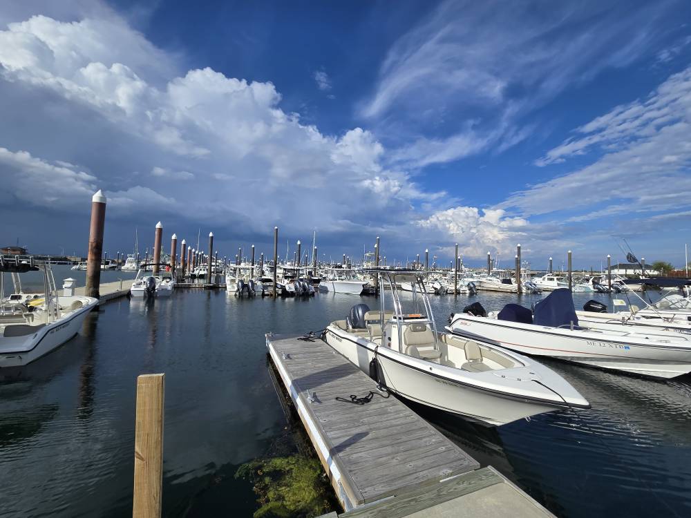
-
Ouch
-

July 2025 Obs/Disco ... possible historic month for heat
Cyclone-68 replied to Typhoon Tip's topic in New England
What a disappointment today. I didn’t predict I’d get a tstorm but except from 1:30 to 3:30 today it was a complete no show almost everywhere. In other words I thought there might have been a few more around. Missed me and then shut off very quickly -
Cell just popped up out of nowhere. It is raining!
-
July 2025 Obs/Disco ... possible historic month for heat
RUNNAWAYICEBERG replied to Typhoon Tip's topic in New England
Dews in Aug?…no way. - Yesterday
-

2025 Spring/Summer Mountain Thread
Maggie Valley Steve replied to Maggie Valley Steve's topic in Southeastern States
I've been under two wet cells this afternoon that has brought over an inch of rain and still raining. Luck of the draw today I suppose. -

July 2025 Obs/Disco ... possible historic month for heat
radarman replied to Typhoon Tip's topic in New England
Missed the strong stuff but caught 2 little pop up storms. Raining now along the boundary -
July 2025 Obs/Disco ... possible historic month for heat
ineedsnow replied to Typhoon Tip's topic in New England
540 line making it to northern Maine with temps in the upper 30s were getting there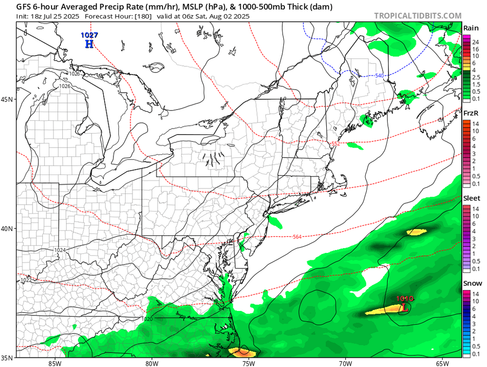
-
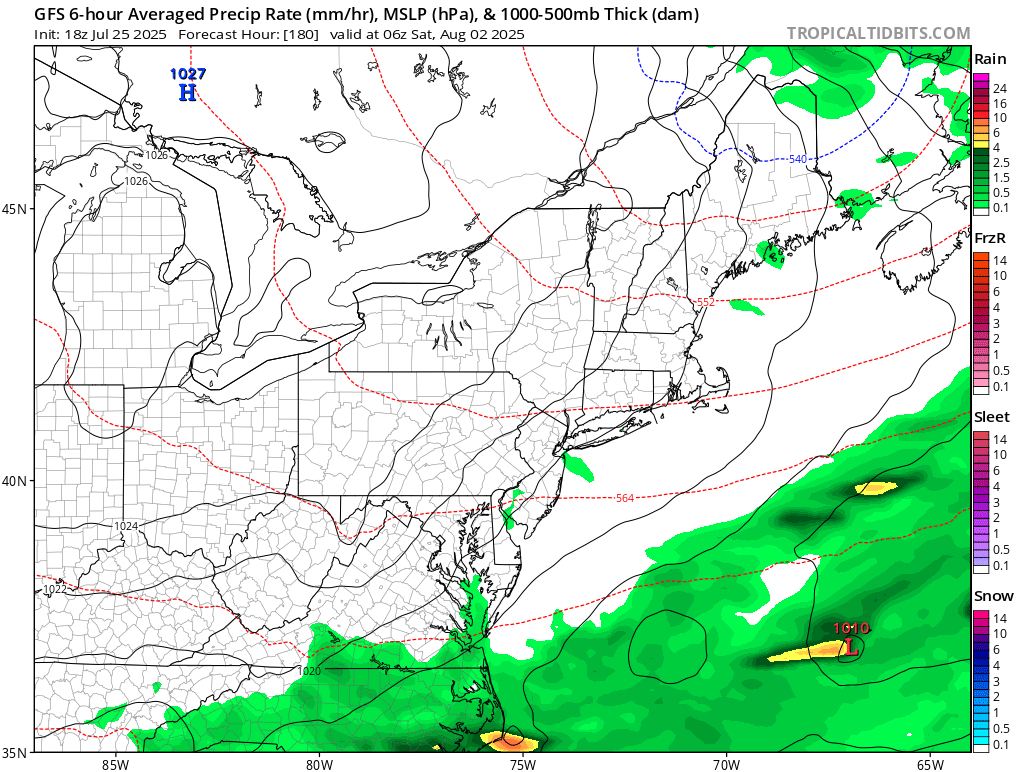
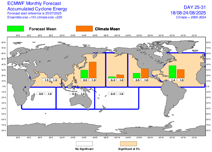
Euro Weeklies ACE for August 18-24 up to 140% of 2005-24 avg. Edit: Also note the green box in ATL is now larger than even the WPAC green box:
-
At least it isn’t a Herculean feat to even get a thunderstorm where you live. It’s like nighttime complexes no longer exist here in West Michigan when they used to be like 80% of our summer precip. This year in particular the main EW frontal zone is either over the Upper Peninsula, or it’s down in Illinois/ Indiana. The transition is a single day, and of course storms fail to fire over Lake Michigan and only get going once the front has passed to the southeast. We also never get those 40 kt low level jets aimed at Michigan these days. They pump moisture at Minnesota, Northern Wisconsin, and even the UP for days, but fizzle to nothing whenever the boundary sinks south into my area.