All Activity
- Past hour
-
The pattern hasn’t even occurred yet and ppl are yelling declaratives
-
I have seen this song and dance many times the past 10 years. 1. Models/weeklies show great pattern weeks away 2. Models/weeklies start delaying or backing off of great pattern 3. Weeks go by and its still at or above average 4. Now its January and the change hasn't really happened. Fab Feb will save us
-

December 2025 Short/Medium Range Forecast Thread
Carvers Gap replied to John1122's topic in Tennessee Valley
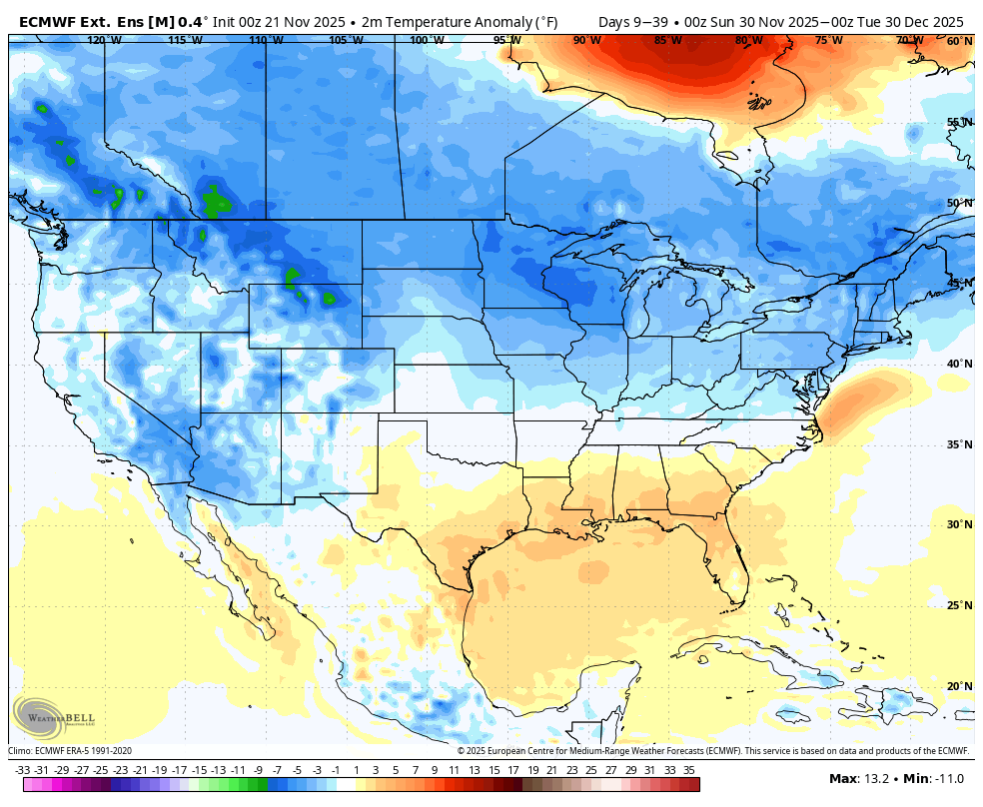
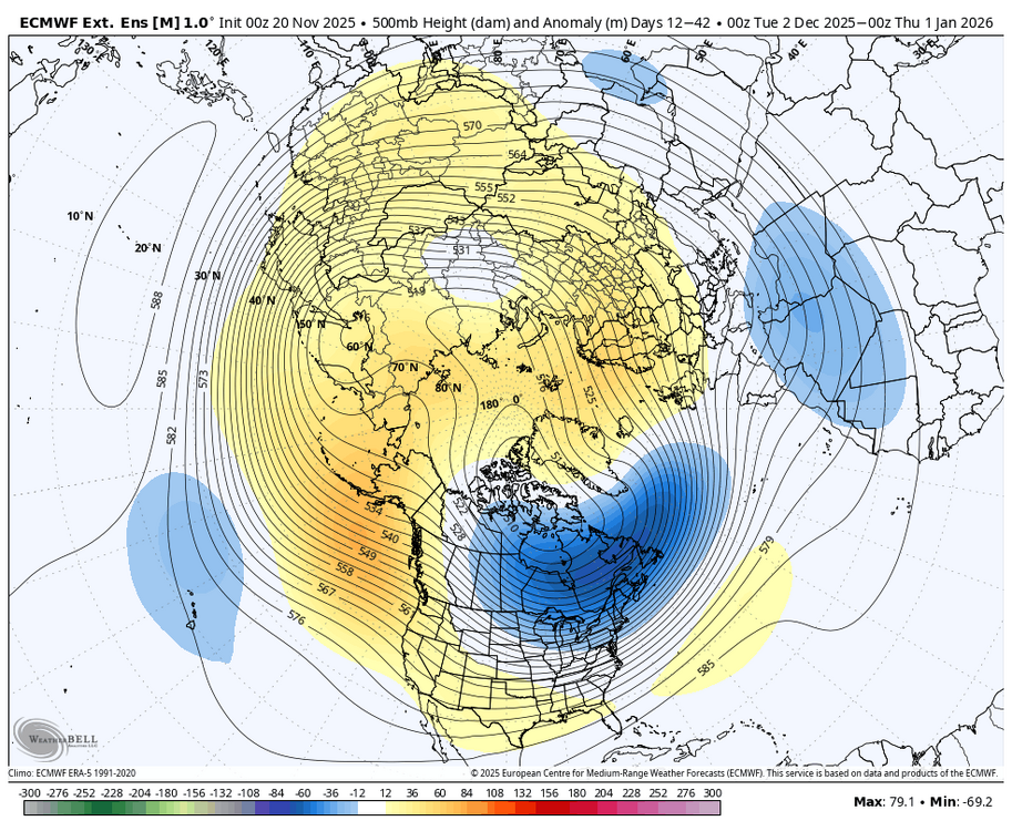
The flip has been quick! The trend has not been our friend, but it is only November and we have just begun to fight...or something like that. The pivot away from BN heights over Tenn Valley has voluminous support both in width and depth in the model world. From ensembles to Weeklies....the trend is towards a standing wave SER over the SE. It can be beaten down, but it immediately returns. Outlier models such at the Euro AIFS and GEPS persist. I don't discount those. If cold is coming, the Canadian model will see it first. What we really want to see is the GFS deterministic to start bringing cold eastward OR the Euro control weeklies. That Weeklies Euro control is a nifty tool. With the exception of a few days earlier this week, it simply refused to be cold for December. The repeated troughs into the Southwest are an ominous look if you like snow and cold. I keep asking myself this question, "Have I been burned more by Baja lows which actually formed...OR have I been burned more by modeling which erroneously (due to feedback) put that feature in the Southwest?" I guess we will find out soon! Modeling often performs so poorly over that region. I find it pretty hard to believe that the MJO in phase 8 is going to end up being warm. So, I do think there will be some moderation(from AN heights) back towards seasonal and maybe even BN heights at some point for a 7-10 day period during December. The Euro Weeklies today are cold at the surface, but I now think that is a bad, bad bias(and a new one at that) and an error. Its 500 heights are now pretty much AN for most of December. That would imply cold will push some, but the SER is the base pattern. Again, this is shoulder season, and trends will likely still change - we can hope, right?! However, for me anyway, my hopes that models are delaying the cold diminish with each passing run. The reality is that it might not come to pass for much of December. But it only takes one memorable snowstorm to make folks forget a warm pattern! Besides, we usually don't get a lot of tracking in the valleys until January or Feb. We aren't even gonna talk about the retrograding BN heights(over the HB) into the West to start January! If LR ext modeling was wrong about December cold, it could certainly be wrong about a January pattern at range! I wish I had better news. I will give it a few more days, and then I will almost certainly have to adjust my winter ideas. Have a good weekend, everyone! At least we are getting some much needed rain. -
You have the greatest hits of subjective posters (3 of them) feeding the general pessimism from the others. I mean I get it...typical year on weather forums, lol.
-
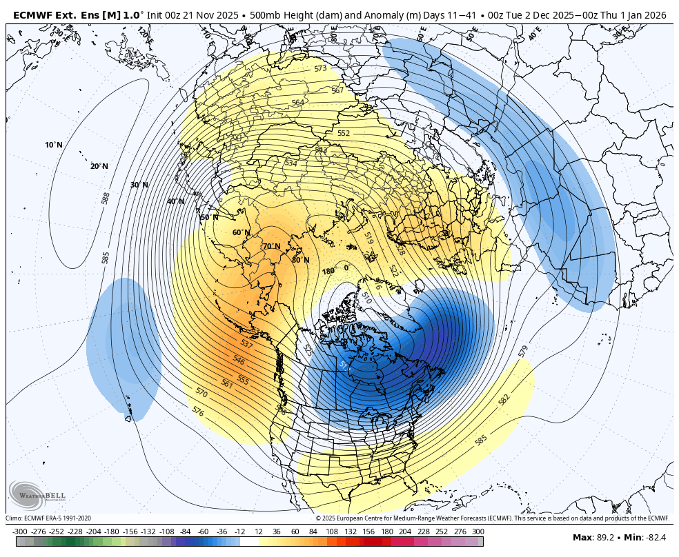
Lol not what I would call a SE ridge.. Follow the height lines. One could argue that would produce a more favorable storm track for our area than the previous run, which might tend towards being too far south. The biggest difference is the ridging poking into Greenland, and it isn't really that much different. I pay less attention to the colors on these super LR tools. Look at the height lines and imagine the flow.
-
But its not showing warmth but yet the same people think winter is already over or its going to be warm. No signals at all of warmth for maybe a few days ahead.
-
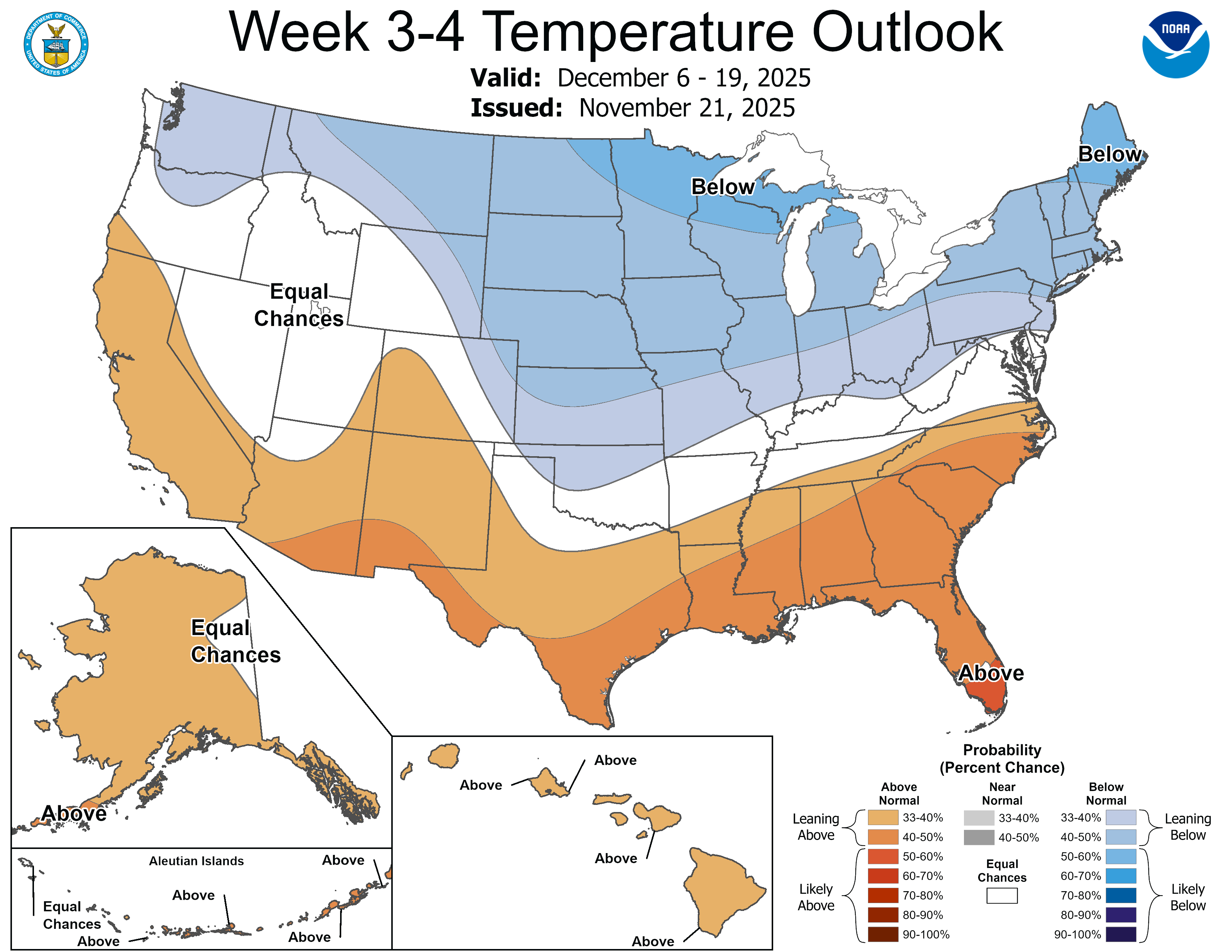
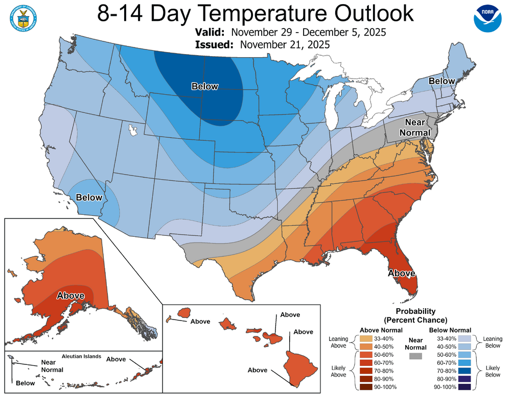
What are you talking about ? This forum is getting ridiculous. December is below normal on the weeklies.

-
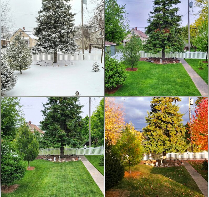
I posted something similar a while ago, but was able to update it with the newest Fall pic. Looking into my backyard. Always feel lucky to have 4 seasons, and it's really neat to see it in a picture form. I didnt have a good spring Pic, had to use one from last May, but now I think I want to do a comparison shot every year.
-
If Simon Lee is correct about 96-97 being a stratospheric analog, then a strengthening SPV into January would fit
-

November 2025 general discussions and probable topic derailings ...
CoastalWx replied to Typhoon Tip's topic in New England
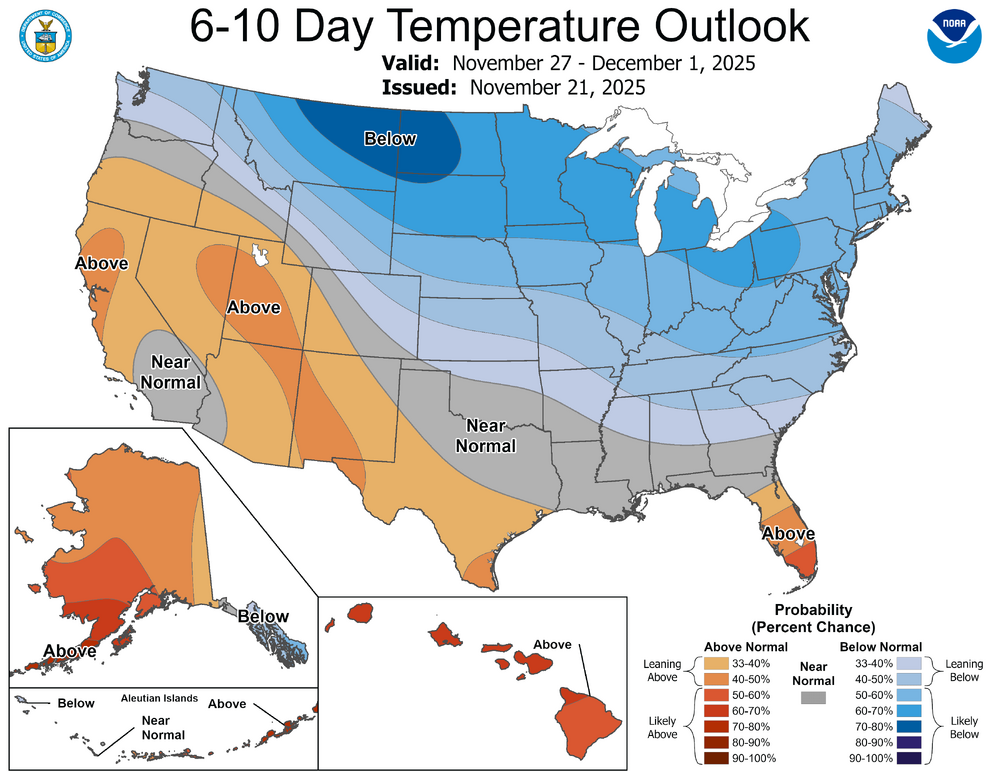
Both progs are really cold in Canada. I see Eduggs is in Jersey so I see why he might be looking for something a little different. I don’t mind being near the battle ground with SE Canada BN in temps. -
December is trending in the wrong direction which is very concerning for an La Niña winter and a big SSWE in November
-
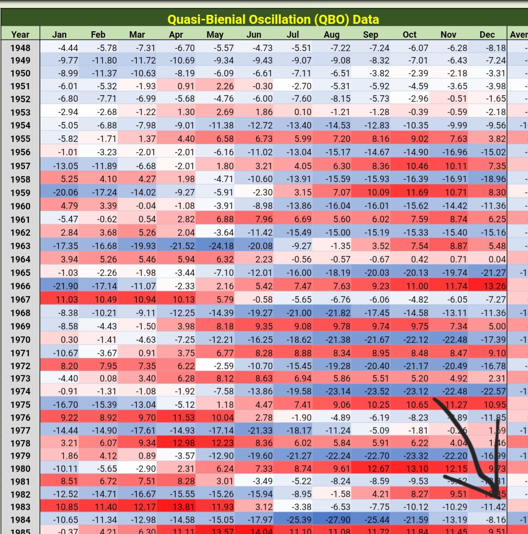
Then I stand corrected on that part of my post. I thought December, 83 was +QBO, my bad on that. But the other aspects I mentioned are definitely correct
-
You are about as objective as a politician answering questions during a press conference.
-

Central PA Fall Discussions and Obs
canderson replied to ChescoWx's topic in Upstate New York/Pennsylvania
My back still hurts from that 2016 event ha -
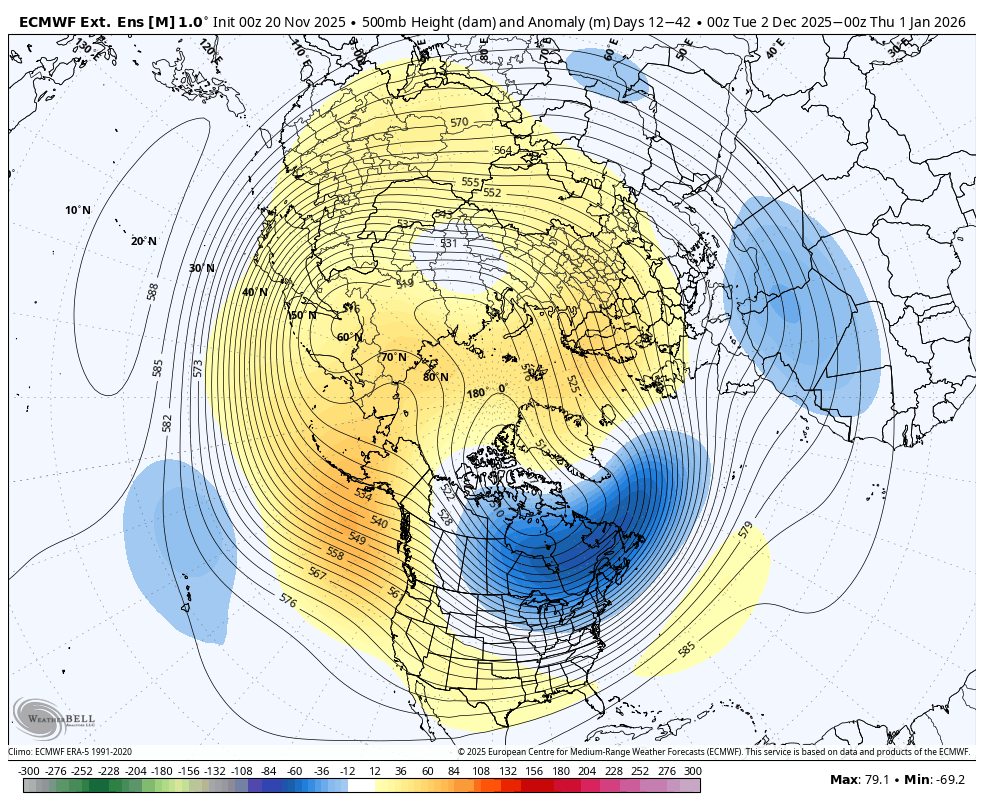
SER asserts itself in the latest WB weeklies. (Today versus yesterday's run.) Whether a blip or the start of a trend away from a December to remember TBD.

-

November 2025 general discussions and probable topic derailings ...
WinterWolf replied to Typhoon Tip's topic in New England
Day 10+ progs don’t usually hold up though. -
I mean, this highlights a problem you bring up all the time about people like snowman spreading their agenda, because here you do a similar thing. Whenever the weeklies show something good you're like "it'll be cold" but whenever the weeklies trend bad you cover it up as shown above.
-
getting some low grade mammies from these elevated waa showers
-
Unless this data is wrong, then you are incorrect. 1983-84 winter was a -QBO winter.

-
You don’t see any warmth, Anthony?
-
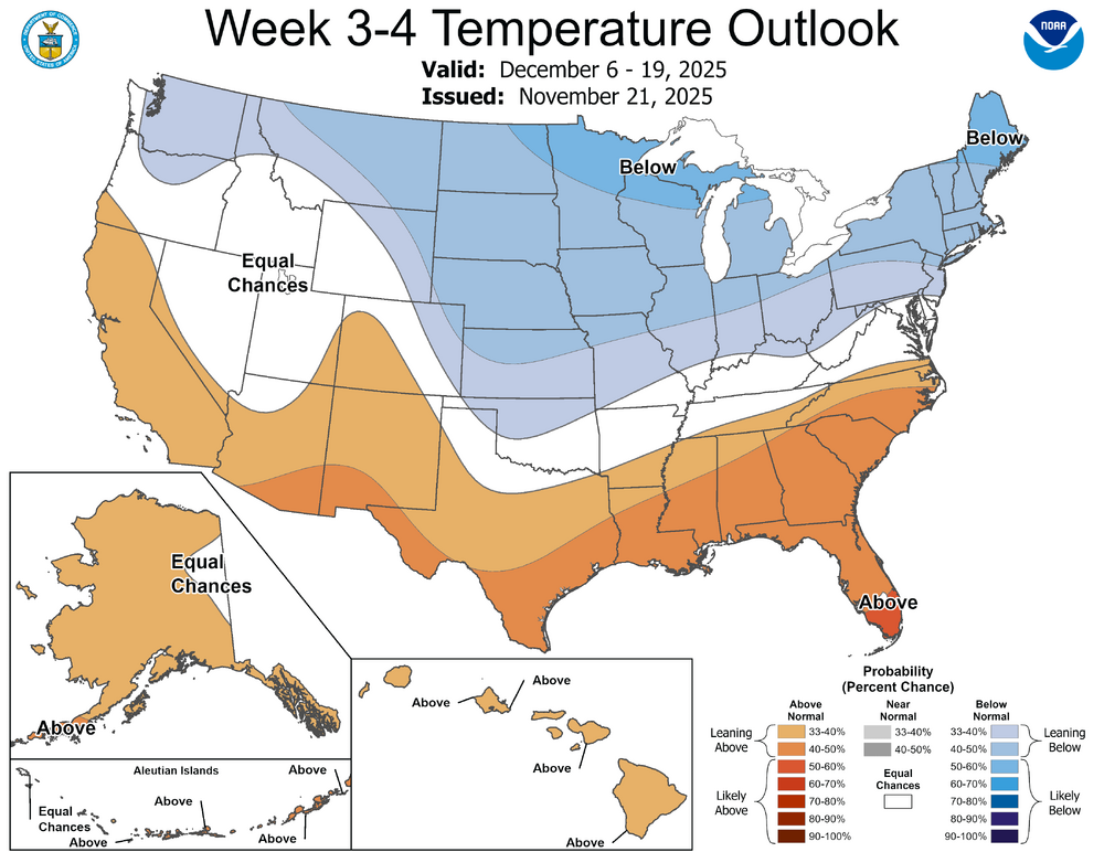
Why? I’m not going crazy. We look at long range guidance ITT every day. This is mainly a long range thread. You just posted weeks 3-4, for example. I’d rather have the most up to date.
-
You will go crazy if you take every run verbatim . I wish the weeklies went back to weekly.
-
Where is the warmth ?
-
As per @GaWx research, 1983 did not have any stratospheric warmings in November or December. Furthermore, 1983 was a volcanic winter with a volcanic stratosphere; courtesy of a VEI-5 tropical eruption the year before in 1982. It was also a +QBO winter and a had a strongly +PDO
- Today
-
Yes, that's the thing many are a bit upset about, Models have expanded it's reach and extended a bit more over time Larry. Of course, that's the nature of these things as we know.