All Activity
- Past hour
-

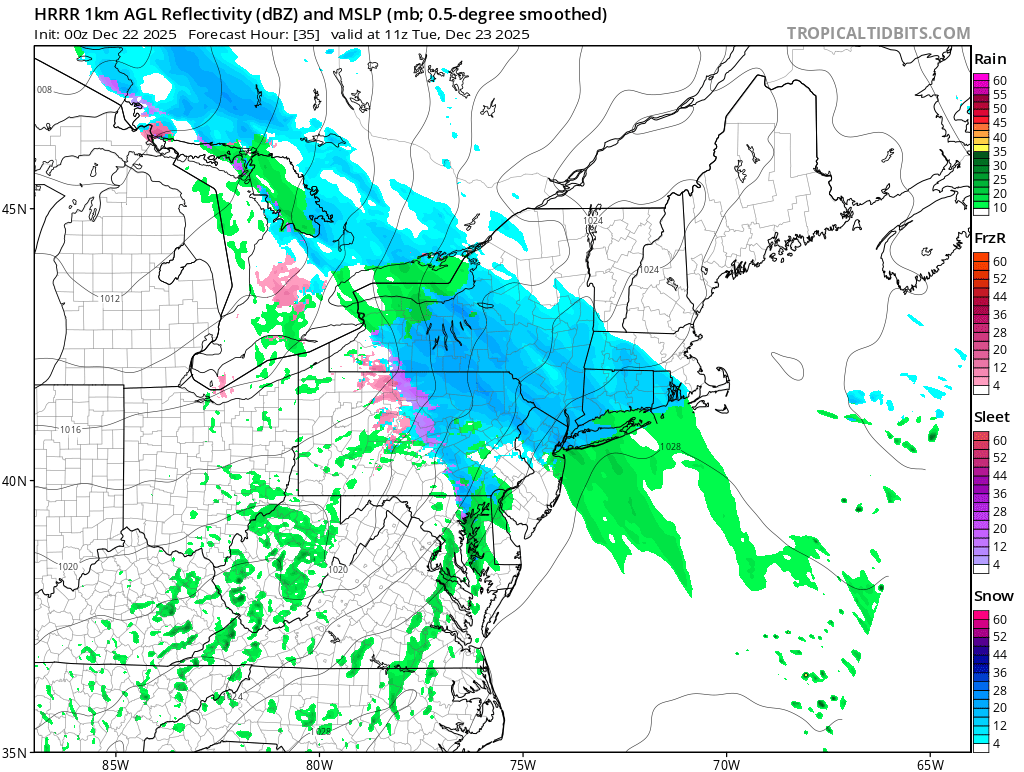
Possible Light Snowfall (1" - 4") on Tuesday Dec 23
MJO812 replied to Northof78's topic in New York City Metro
HRRR shifted south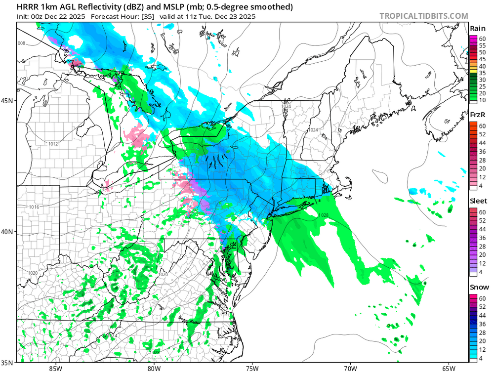
.thumb.png.d01683a044485f8356a649e61f33bf4f.png)
-

Possible Light Snowfall (1" - 4") on Tuesday Dec 23
donsutherland1 replied to Northof78's topic in New York City Metro
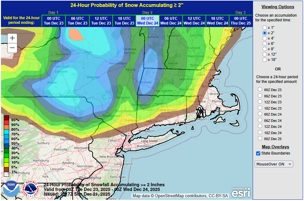
No changes in thinking at this time. With marginal temperatures and light precipitation rates, most of the New York City area will probably see little more than a coating. The City will likely see temperatures remain above freezing for most or all of the storm. A trace of snow cannot be ruled out for parts of the City. Nearly three-quarters of events with temperatures above freezing saw no measurable snowfall while just one-in-six had 1" or more in Central Park's climate record. It is possible that the precipitation could mix with or end as some light rain or drizzle in and around New York City. The distant northern and western suburbs continue to have the best chance of seeing 1"-2", as readings will likely be near or perhaps even a little below freezing during much of the event. The latest WPC maps for 24-hour probabilities of 1" or more and 2" or more snowfall are below: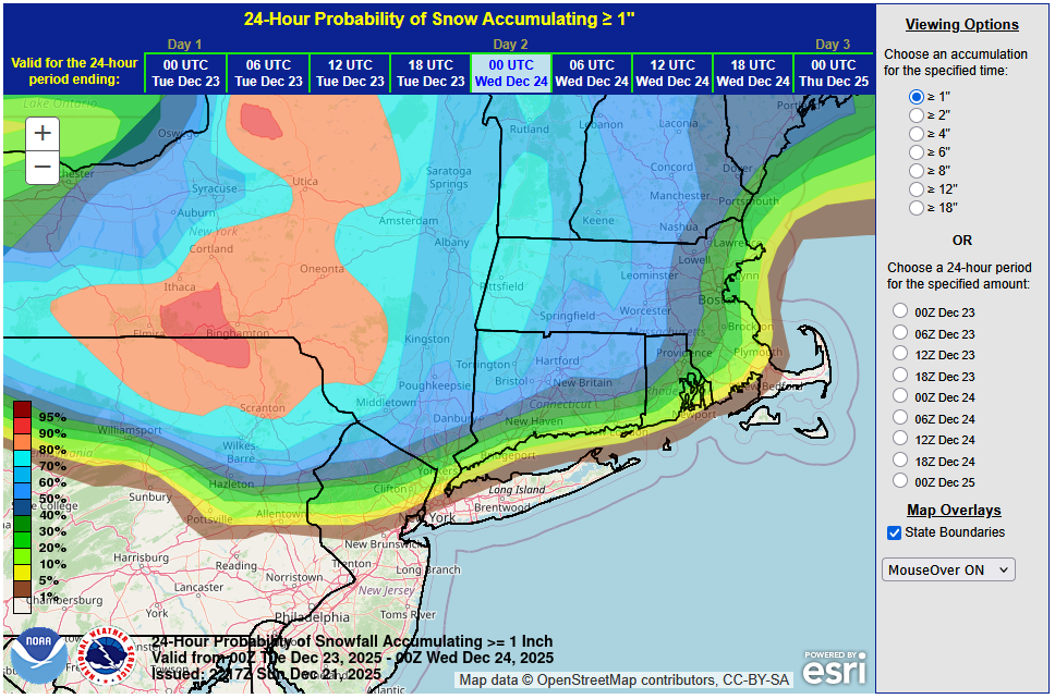
-

2025-2026 ENSO
40/70 Benchmark replied to 40/70 Benchmark's topic in Weather Forecasting and Discussion
Sure...reasonable. -
One thing that throws a monkey wrench into assessing vs climo is the potential ENSO impact though. I believe that La Nina's have a tendency to be more front loaded and can often be quite toasty in February (keeping in mind that "frontloaded" is relative; just because December is the least bad doesn't mean it's good.) On the other hand a good El Nino might be just hitting it's stride at the start of February. I currently have no idea how impactful or not the fading Nina is going to be going forward. If it couples strongly, then there is reason to be concerned about late Jan and Feb.
-

White Christmas Miracle? December 23-24th
Damage In Tolland replied to Baroclinic Zone's topic in New England
It’s ok to say Tolland if that’s what you think. But I haven’t seen anything that shows that -
2025-2026 ENSO
40/70 Benchmark replied to 40/70 Benchmark's topic in Weather Forecasting and Discussion
That guidance shows it essentially neutralizing by January 5th...pop a +TNH mid-month....done. -

White Christmas Miracle? December 23-24th
Sey-Mour Snow replied to Baroclinic Zone's topic in New England
You get the idea.. Generally NW of Waterbury and SW of ORH would be the area most at risk to be skunked in between -
2025-2026 ENSO
40/70 Benchmark replied to 40/70 Benchmark's topic in Weather Forecasting and Discussion
Yes, there is. -

White Christmas Miracle? December 23-24th
RUNNAWAYICEBERG replied to Baroclinic Zone's topic in New England
Snowy tuesday morning…good enough. -
White Christmas Miracle? December 23-24th
Damage In Tolland replied to Baroclinic Zone's topic in New England
most of guidance looks like ORH/ RI east may have issues . Or maybe doesn’t happen at all . Every map has it on n some degree in that axis -

White Christmas Miracle? December 23-24th
moneypitmike replied to Baroclinic Zone's topic in New England
91 and RT 2 are perpendicular.......how can you be between them? -
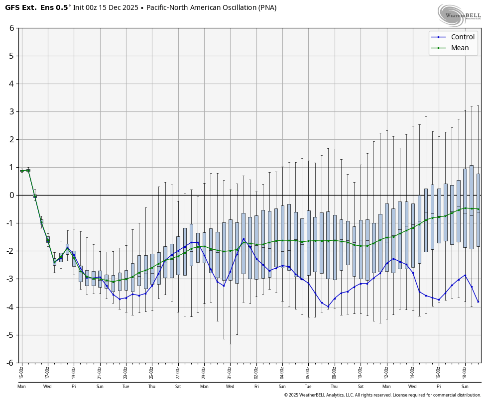
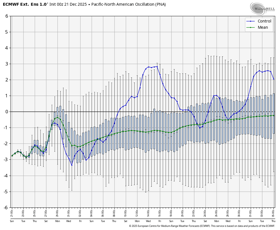
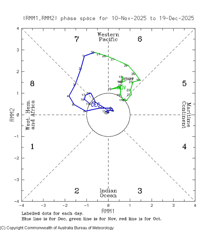
There is no evidence for a +PNA in January
-
MJO is in day 3 (12/17-19) of the 3rd phase 8 of this month:
-
White Christmas Miracle? December 23-24th
Sey-Mour Snow replied to Baroclinic Zone's topic in New England
Most likely area to get the shaft is between 91 in CT and RT 2 in Mass.. Most guidance has it redeveloping nicely around ORH and points NE... -
I must have missed him discussing the TNH+. He seemed oddly quiet in early December. I believe he was having some health issues so I ascribed it to that. Maybe it just wasn't popping up on my feed for some reason.
-
we have folks that cancel winter during the prior summer. That's routine 'round these parts lol.
-
sometimes he lets the desire to troll cloud his reasoning.
-

White Christmas Miracle? December 23-24th
HoarfrostHubb replied to Baroclinic Zone's topic in New England
It will be over Corey -
that's late for him tbh
-

December 2025 Short/Medium Range Forecast Thread
Golf757075 replied to John1122's topic in Tennessee Valley
Carver I believe it will be hard pressed to get the cold further west due to the east based nao. If it morphs into west based, all bets are off. We deal with the hand delt -
yeah i'd say it's the last two weeks of Jan / first two weeks of Feb. There's always a delay at our latitude in both winter and summer in terms of peak "climo" and when the solstice happens. Our hottest weeks of the summer are generally mid July to early August.
-

White Christmas Miracle? December 23-24th
WxWatcher007 replied to Baroclinic Zone's topic in New England
Stop being so negative -
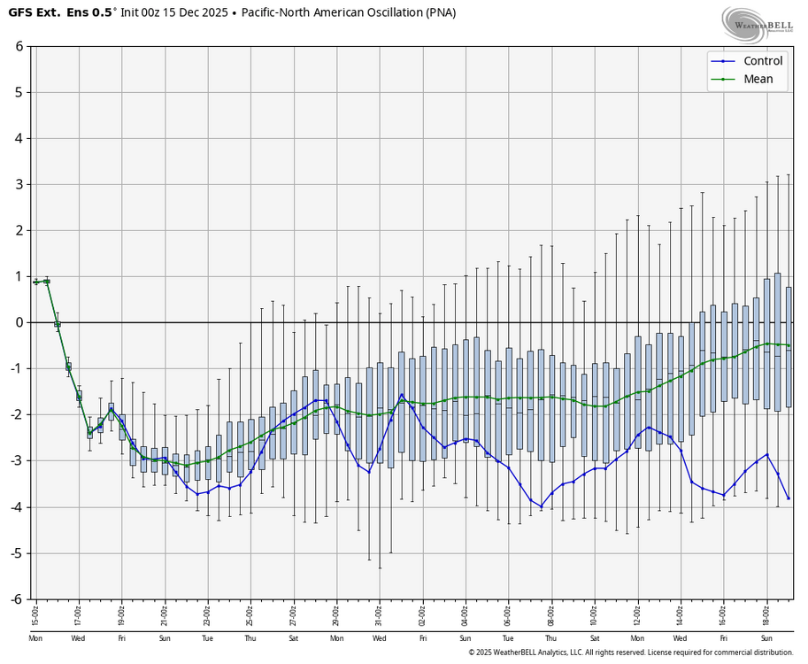
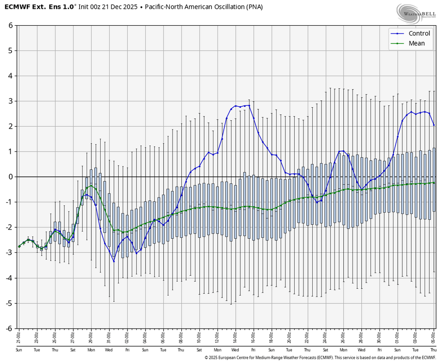
The models are pretty unanimous on continuing the -WPO into Jan and the strongly -WPOs in Dec strongly support a -WPO as we know. We also know that the -ENSO -PNA stats since 1983-4 suggest good support for a +PNA Jan. But both the Euro Weeklies and extended GEFS continue to show a -PNA throughout Jan (see images below). Are you saying these models are totally wrong and will correct toward +PNA? If so, why do you think they’re going -PNA? Persistence? (even though I’ve seen the EW predict PNA changes and do well).
-

White Christmas Miracle? December 23-24th
George001 replied to Baroclinic Zone's topic in New England
Yeah this has always been a Maine storm -
December 2025 regional war/obs/disco thread
moneypitmike replied to Torch Tiger's topic in New England
Yup--south coast. For many years, we lived in Shelburne in western Franklin County.
.png.8e1dd6ced38ed4a5839283e2fa9b33e4.png)