All Activity
- Past hour
-
You might soon have to deliver water to yourself at the rate your going.
-
I got .29" in Tamaqua. While I saw a good one driving through Cross Keys and Leesport, north of Reading on PA61, Tamaqua was on the fringe of the first storm and missed completely on the second one.
-

July 2025 Obs/Disco ... possible historic month for heat
kdxken replied to Typhoon Tip's topic in New England
"Pretty warm " < inferno -

July 2025 Obs/Disco ... possible historic month for heat
HoarfrostHubb replied to Typhoon Tip's topic in New England
It’s a decent signal at this range. Likely to change of course. -
July 2025 Obs/Disco ... possible historic month for heat
kdxken replied to Typhoon Tip's topic in New England
That's the best you can do? Lolz -
The drought monitor says different lol. I know it's frustrating but your area is no difference than anywhere else. When the worm turns, look out. NAM brings storms into your area this evening.
-
0.48", 5.05" month
-

July 2025 Discussion-OBS - seasonable summer variability
SACRUS replied to wdrag's topic in New York City Metro
76 / 73 . Clear. Onshore flow today keeps it cooler before next round of rain on Sunday. Mainly 80s today some of the inland hotter areas could get to 90 further inland. Tomorrow - cloudy - storms could dump 1-3 inches of rain. Heat back Mon - Wed (perhaps Thu) with front on Thursday. Do see seabreeze and more E component to flow Mon-Wed so heat inland - could be tough along the coasts and city. Could be next slow moving boundary Thu - Fri with some storms and rain >2-3 inches. Beyond there Cooler 8/1 - 8/6 lots of onshore flow - keeping it near normal overall. Flow comes around with warm-hot / humid overall by 8/7 or 8th. Beyond there much warmer as ridge expandings east and heat building to our west. -
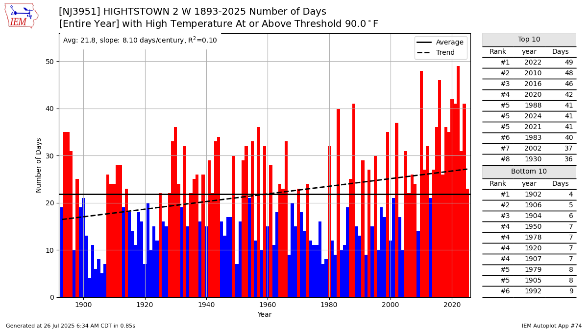
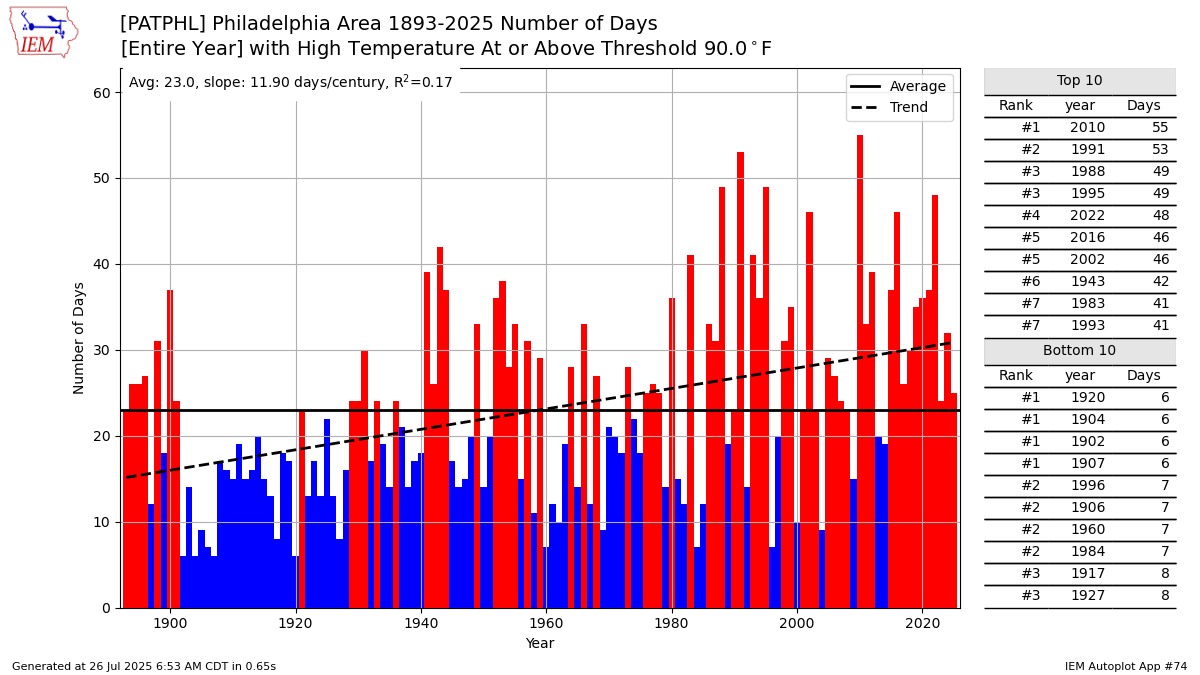
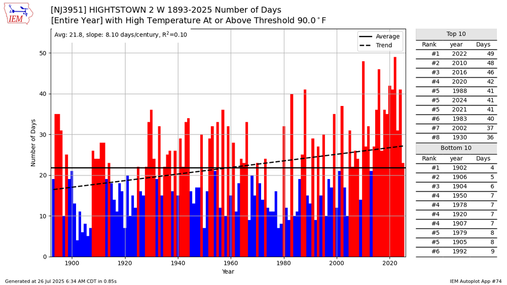
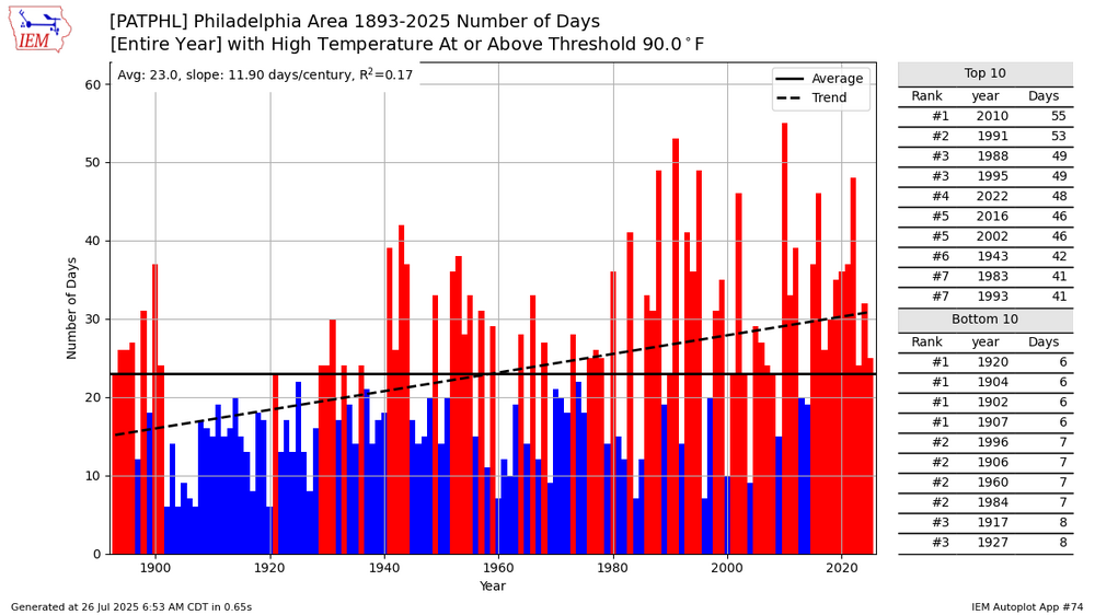
Many areas in the East have also seen a steady increase in 90° days over the years. In the old days it was rare for areas to reach 40 days of 90°. Now it’s occurring much more frequently.
-

July 2025 Obs/Disco ... possible historic month for heat
dendrite replied to Typhoon Tip's topic in New England
EPS is pretty warm after the cool down next weekend. GEFS and skynet aren’t quite as warm. If that ridge folds over we could get a plume of that bigger heat to advect in.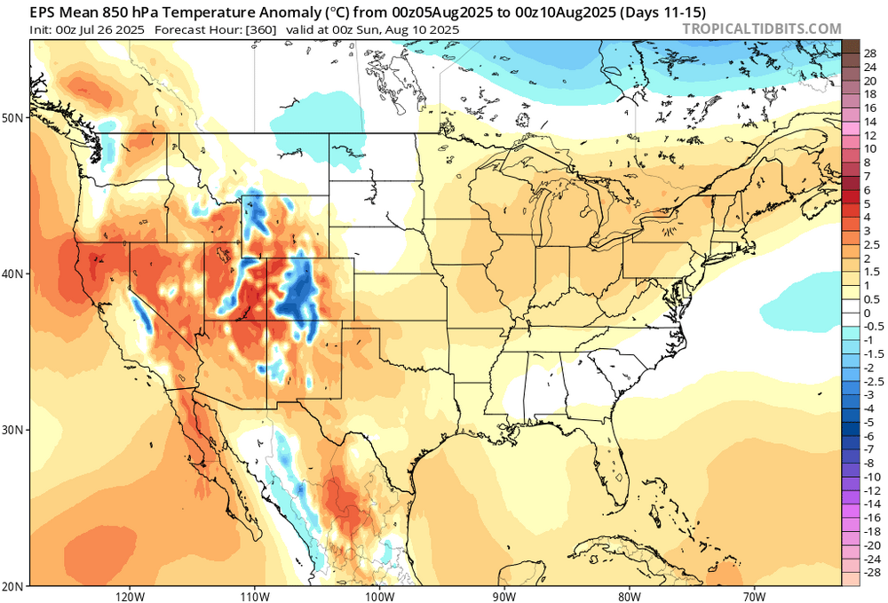
-

July 2025 Discussion-OBS - seasonable summer variability
wdrag replied to wdrag's topic in New York City Metro
Not sure if anyone is noticing... near 100 possible central LI Wed... EC past several cycles. then its all done for 10 days. -
See, thats why it should be 100, not 98 or 99, which leaves you feeling unsatisfied. Just get it to 100 for a day or two every summer and then let it be cooler for the rest of the summer.
-

July 2025 Discussion-OBS - seasonable summer variability
LibertyBell replied to wdrag's topic in New York City Metro
also are we sure that this instrumentation is properly sited-- 101 to 102 seems a bit high.... how do you record max/min data on these instruments and how do you put it in tabular form? -
July 2025 Discussion-OBS - seasonable summer variability
LibertyBell replied to wdrag's topic in New York City Metro
Chris how do you put this data in tabular form and when will that micronet start recording wind direction as well as wind speed? -
July 2025 Obs/Disco ... possible historic month for heat
HoarfrostHubb replied to Typhoon Tip's topic in New England
Nice heat spell Monday-Wednesday -
But that chart also assumes no large scale geoengineering projects will happen, which I don't think is true. Beginning in 2030 or maybe even before, we'll very likely see such projects to cool down the climate, humanity won't stand still and just let the climate warm like that.
-
Yes, the west has gotten hotter and drier while the east has gotten wetter and warmer (warmer refers to minimums while hotter refers to maximums). But in this context 1995 is when we switched to a +AMO
-
This is why I have been saying my thoughts about a cold-neutral may turn out to be wrong and we actually do see an official La Niña. Also, if you look at that subsurface signature, it’s definitely not arguing for an east-based event. Not saying it can’t change by the end of fall but that does not look like an east-based subsurface right now, (Nino 1+2 has been skewed warm for months) which may not really matter all that much if this -ENSO event stays weak…..
-

July 2025 Obs/Disco ... possible historic month for heat
RUNNAWAYICEBERG replied to Typhoon Tip's topic in New England
You can tell they are holding on to every drip of dew point. -
For us it was the 1990s.
-
Here was me again getting missed just to the north. SEVERE drought in progress here almost no rain since July 2
-
Bigger question is what kind of geoengineering can we do to cool the oceans back down, I envision a device that would overturn the oceanic circulation and constantly bring up cooler ocean waters from the depths. Yelling about reducing fossil fuels isn't going to do anything-- it's already too late for that-- humanity must actively start large scale geoengineering projects to reverse what's going on.
-
Sure bud
-
Me? Are you joking? The context I provided about that chart is 100% correct. The claim that this is the “23rd lowest percentage of 90 degree days” is 100% made-up BS.
-

July 2025 Obs/Disco ... possible historic month for heat
Damage In Tolland replied to Typhoon Tip's topic in New England
The three ACATT amigos very very worried. Uh-oh