All Activity
- Past hour
-
Even KNAK listed a DP of 68, but my personal swamp still clinging to 73 DP as of 7am
-
I am not sure what you mean by using the term nebulous and obfuscate. The issue with relying on modern standards based on 30 year climate means are that they are continuously getting warmer every 10 years. So the bar is lower for defining a colder winter. A departure isn’t the actual temperature. My whole point by using long term rankings back to 1895 is that it’s a fixed number which everyone can relate to. The 3 month average last winter was in no way shape or form considered cold for the CONUS. It was the 27th warmest winter on record for the CONUS at 34.07°. But I agree with you that is was a cold January overall for the CONUS at 33rd coldest and 29.21°. The temperatures rebounded in February to 34.81° or 54th warmest. But there were still some localized cold pockets out West in February. The storm track for NYC last winter was very warm. On the 11 days which .25 or more of precipitation fell the average temperature was 41.0°. This is why the snowfall was so low again continuing the pattern since 2018-2019. The climate periods with similar temperatures going back to the 1970s had very distinct average temperatures across the CONUS and various regions. The first period from 1895 to 1982 had a much colder temperature range. So during each succeeding climate period the coldest winter have been getting warmer at a slightly faster pace than the warmest winters have been getting warmer. This recent 10 winter year period since 2015-2016 has been unprecedented in the modern climate history of the CONUS. There has been no 10 winter period this warm. This is especially the case when looking at how fast the coldest winters have been warming. Coldest winters by decade 2020s so far….33.64° 2010s…………..30.70° 2000s…………..31.26° 1990s……………31.80° 1980s…………...30.56° 1970s……………26.62° 1960s……………30.65° 1950s……………31.44° 1940s……………30.14° 1930s…………...27.78° 1920s…………...28.73°
-
For second day in a row, JUST missed a 'warm minimum' for the date. 69.2 low, record is 69.9 from 2015. Currently 70.2/69.4 at 8 am with cloudy skies.
-
.05” of precipitation yesterday. Beautiful morning out 62° for the low.
-

2025 Atlantic Hurricane Season
BarryStantonGBP replied to BarryStantonGBP's topic in Tropical Headquarters
Seems to be the new normal -
2025 Atlantic Hurricane Season
BarryStantonGBP replied to BarryStantonGBP's topic in Tropical Headquarters
Mate I’m brand new here don’t know what you’re on about -
What should be the best Meteor shower days this month?
-

July 2025 Obs/Disco ... possible historic month for heat
moneypitmike replied to Typhoon Tip's topic in New England
Perfect coc day today. -

July 2025 Obs/Disco ... possible historic month for heat
kdxken replied to Typhoon Tip's topic in New England
Heatwave looks doable in spots at the end of the week. - Today
-

2025-2026 ENSO
40/70 Benchmark replied to 40/70 Benchmark's topic in Weather Forecasting and Discussion
Its not going to be an official La Nina, but that doesn't matter...agree otherwise. -
2025-2026 ENSO
40/70 Benchmark replied to 40/70 Benchmark's topic in Weather Forecasting and Discussion
I think its still going to be a pretty costly season due to a late home-brew barrage. -
2025-2026 ENSO
40/70 Benchmark replied to 40/70 Benchmark's topic in Weather Forecasting and Discussion
I kind of get some 2007-2008 vibes for the coming winter.... -

2025-2026 ENSO
PhiEaglesfan712 replied to 40/70 Benchmark's topic in Weather Forecasting and Discussion
Yeah, even without the blocking, we still had one final hurrah during the final third of March. 2011-03-23 40 32 36.0 -8.8 29 0 0.87 T 0 2011-03-24 44 30 37.0 -8.2 28 0 0.09 1.0 1 2011-03-25 42 28 35.0 -10.5 30 0 0.00 0.0 0 2011-03-26 40 26 33.0 -12.9 32 0 0.00 0.0 0 2011-03-27 45 28 36.5 -9.7 28 0 0.00 0.0 0 2011-03-28 45 26 35.5 -11.1 29 0 0.00 0.0 0 2011-03-29 49 31 40.0 -6.9 25 0 0.00 0.0 0 2011-03-30 53 36 44.5 -2.8 20 0 0.01 0.0 0 2011-03-31 43 37 40.0 -7.7 25 0 0.13 T 0 This turned a solid warm first two-thirds of the month into a negative departure. -
July 2025 Obs/Disco ... possible historic month for heat
kdxken replied to Typhoon Tip's topic in New England
-

July 2025 Obs/Disco ... possible historic month for heat
HoarfrostHubb replied to Typhoon Tip's topic in New England
What? What? I can’t hear you! Def a good porter. They need to sell snacks though. -

July 2025 Obs/Disco ... possible historic month for heat
Damage In Tolland replied to Typhoon Tip's topic in New England
Poor ACATT -
DP still in the low 70s. Should be Friday/Saturday until we see that again.
-
Indeed. And I definitely agree with you that there is going to be a real strong tendency for -PNA this winter given the 2nd year -ENSO. Very extensive research supports this
-

July 2025 Obs/Disco ... possible historic month for heat
dendrite replied to Typhoon Tip's topic in New England
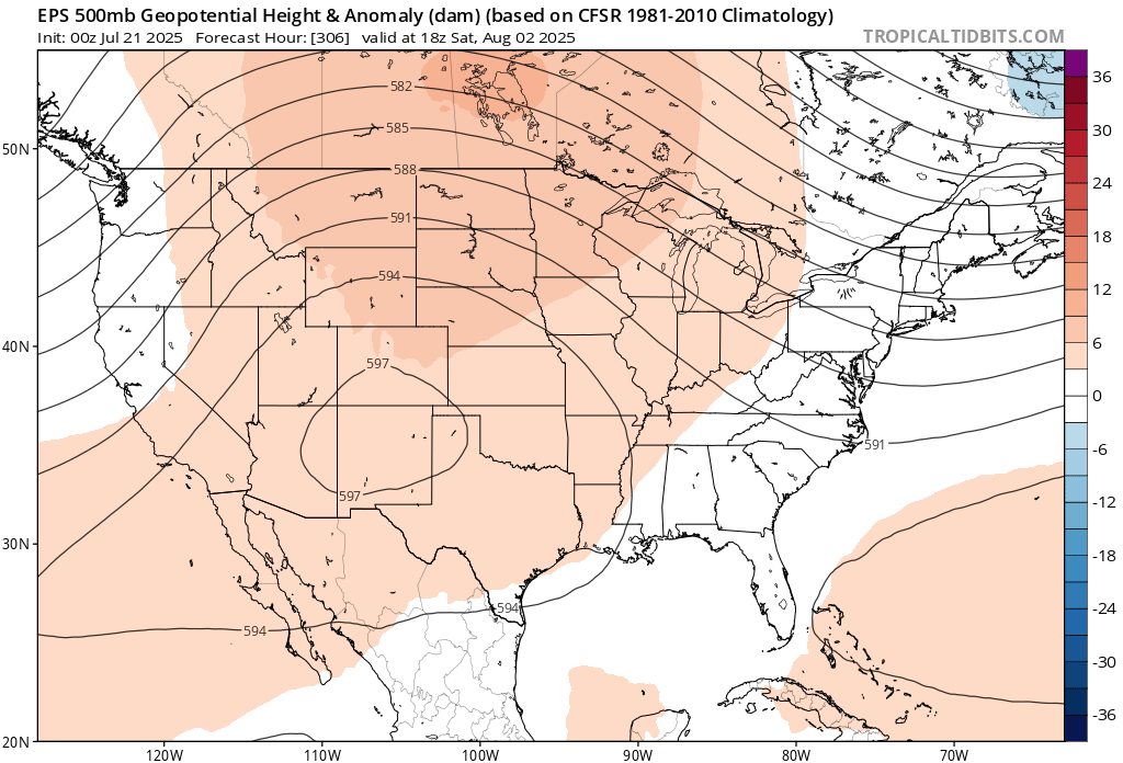
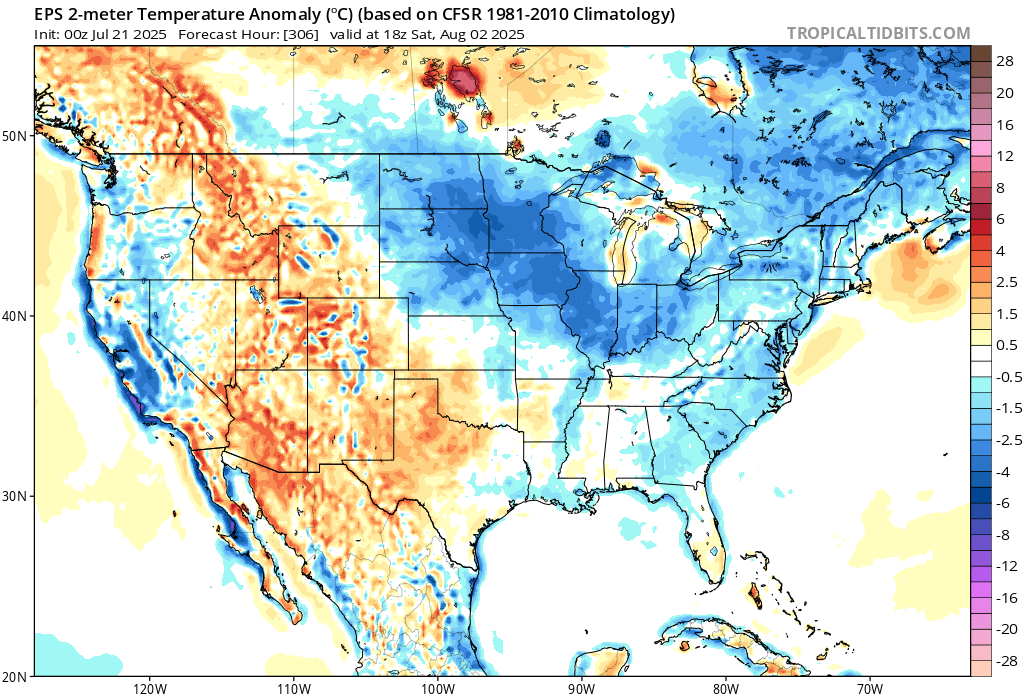
The maps are trash…especially the 2m 18z anomaly ones. Yeah…it’s going to be that cold in the upper midwest with this look.
-
IMO we are all lined up to see a well below average Atlantic hurricane season in both named storms and ACE
-

July 2025 Obs/Disco ... possible historic month for heat
Torch Tiger replied to Typhoon Tip's topic in New England
what am I looking for -
I have no doubt that if the blocking didn’t break down in February, NYC would have seen more snow that winter than the 95-96 winter and probably by a lot
-

2025 Atlantic Hurricane Season
LongBeachSurfFreak replied to BarryStantonGBP's topic in Tropical Headquarters
Pretty much mirrors the sea surface temp profile from earlier. Having the subtropics warmer then the tropics destroys vertical instability in the MDR. The reason they think the season is weighted towards the second half is climatological. Seasonally the subtropics will begin to cool faster then the tropics and return a more normal instability profile. Last year should have been a wake up call. Warmer water doesn’t automatically mean a hyperactive season. -

July 2025 Obs/Disco ... possible historic month for heat
ineedsnow replied to Typhoon Tip's topic in New England
We take!
-