All Activity
- Past hour
-
You can see the temps bounce up and down on the hrrr. Almost looks like a batch of heavy rain late morning ahead of LLJ core and then more scattered after until fropa. Any breaks in between and sky brightness will help boost temps a tick or two. Hrrr is like 61 here lol.
-

E PA/NJ/DE Winter 2025-26 Obs/Discussion
RedSky replied to LVblizzard's topic in Philadelphia Region
3" depth 48F -

December 2025 regional war/obs/disco thread
weatherwiz replied to Torch Tiger's topic in New England
Still have to watch though because if its just a non stop rain with no break between the initial area and line ahead of the front, gusts will be greatly diminished. It looks like the window for gusts 50-60+ is going to be relatively small and might end up being something more localized versus widespread. If there is a break between the initial area and incoming line, it will absolutely rip for a few hours -
The modeling (ensembles/operationals) this afternoon is showing a decidedly east-based -NAO going into the beginning of January, still holding on to the -PNA as well. If the true east-based -NAO is correct, it would be quite the change from what we have seen over the last 10 years or so with -NAO’s,
-
At least seven straight year of it raining at some point on NYE! Last time it snowed, I believe, was 2009.
-
Agreed. If we punt all of January then winter is 75% over by that point and we're in sun angle season.
-

December 2025 regional war/obs/disco thread
Damage In Tolland replied to Torch Tiger's topic in New England
-

Central PA Winter 25/26 Discussion and Obs
Mount Joy Snowman replied to MAG5035's topic in Upstate New York/Pennsylvania
I mean maaaaybe, perhaps, possibly, mayhaps......but not really. For me personally, no I do not even remotely consider 1 or 2 days in the low 50s in mid-December to be a "torch period". I would also point out that he forecasts for the LSV, not Maine haha, and I assume the people to whom he was responding were also inquiring about the local area, not Canada. I digress. -
December 2025 regional war/obs/disco thread
weatherwiz replied to Torch Tiger's topic in New England
yup for sure. I am definitely a bit more intrigued than I was 24 hours ago. -
man all the good vibes destroyed in 12 hours. The AI had a decent look though
-
He’s around. But in his defense, the NWS is really getting hosed. It’s a tough situation for all of them and I’ll just leave it at that.
-
December 2025 regional war/obs/disco thread
Damage In Tolland replied to Torch Tiger's topic in New England
The LLJ also backed west and slowed down from earlier in the week which is helping -
53 degrees here right now. Beautiful day. The cold and snow was nice, but it's also nice to have a warmer day for running outside.
-
December 2025 regional war/obs/disco thread
Damage In Tolland replied to Torch Tiger's topic in New England
I remember the posts and poster he got upset about lol. -
December 2025 regional war/obs/disco thread
weatherwiz replied to Torch Tiger's topic in New England
That LLJ does hang back through early afternoon. Unlike that setup some weeks back where models trended east with the LLJ inside of 48 hours...this one has not -
I noticed quit a while ago but was reminded when Scott mentioned it so thought i would ask.
-
December 2025 regional war/obs/disco thread
Damage In Tolland replied to Torch Tiger's topic in New England
Yeah those typically are more conservative. Eye popping to see the gusts on those .60-70+. Hoping …. -
December 2025 regional war/obs/disco thread
Damage In Tolland replied to Torch Tiger's topic in New England
He’s been gone since very early in govt shutdown . Took offense to a few posts . I was wondering who else would notice -
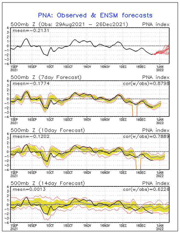
On 12/26/21, when the PNA had been negative all month/way down at -1.8 that day and Baltimore (among others) had just had a miserably mild 68F Christmas high with very mild to continue through New Year’s, this (see image below) was the 12/26/21 GEFS two week PNA forecast, which went to 1/9/22: still down at -0.6 on 1/9/22 and no clearcut sign that 1/9/22 was going to be the start of a 38 day long +PNA as well as Jan ending up the snowiest month by far there since Jan of 2016 along with it being the coldest month since Jan of 2018: @donsutherland1
-
December 2025 regional war/obs/disco thread
weatherwiz replied to Torch Tiger's topic in New England
It certainly may be. It all depends on really what side of everything we're on. We could be southwesterly or northeasterly. Heck, probably even get a mixture of both. -
Those gust maps from the 3k/HRRR on COD are usually a little more conservative than some of those gust products and they’re both pretty big down in SNE tomorrow. A lot of 60kt+.
-

December 2025 Short/Medium Range Forecast Thread
Carvers Gap replied to John1122's topic in Tennessee Valley
@nrgjeff, are the new AI ensembles decent? I notice the 12z GEPS and both AI ensembles (GFS/Euro) had a lot of cold members after 300. The Vols losing three straight was like looking at non-stop chinooks on modeling - same result, same set-up. We needed that Louisville shake-up(red like an NAO! - it's a sign). -
Speaking of him, Where has Chris been?
-

December 2025 regional war/obs/disco thread
DavisStraight replied to Torch Tiger's topic in New England
Is there a map anywhere with totals from 96? I think I had more than 2015 too. -

December 2025 regional war/obs/disco thread
Torch Tiger replied to Torch Tiger's topic in New England
Hopefully some wind damage, nothing else exciting to track


