All Activity
- Past hour
-
For an “in our backyard” standpoint we cancelled our kids party on 9/26; rescheduled for this Sunday. 35+ adults and kids that need to remain outside… Needless to say, hitting refresh often before I decide to host it or cancel.
-
But this is the latest forming first hurricane of season ever?
-
 international drug mart: OmniRxDirect - worldwide pharmacy online
 -
https://auroramedsdirect.com/# canadian pharmacies
-

2026-2027 Record-breaking El Nino
Keith Central PA replied to Stormchaserchuck1's topic in Weather Forecasting and Discussion
You said no snow, but you can get a few inches of snow in a bad pattern. Starting off as snow changing to rain..some sort of clipper ect..from late November till late March it can and will snow -
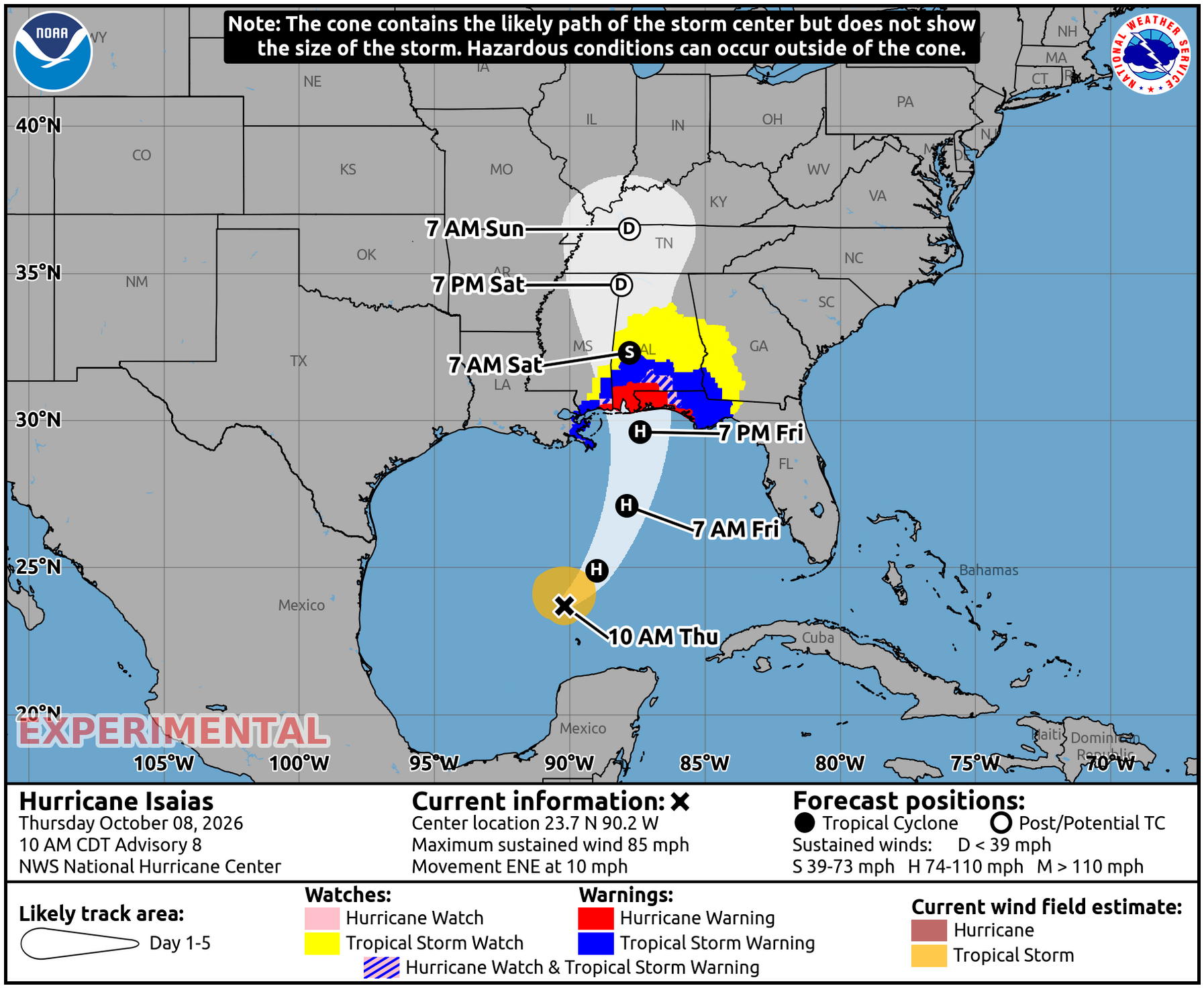
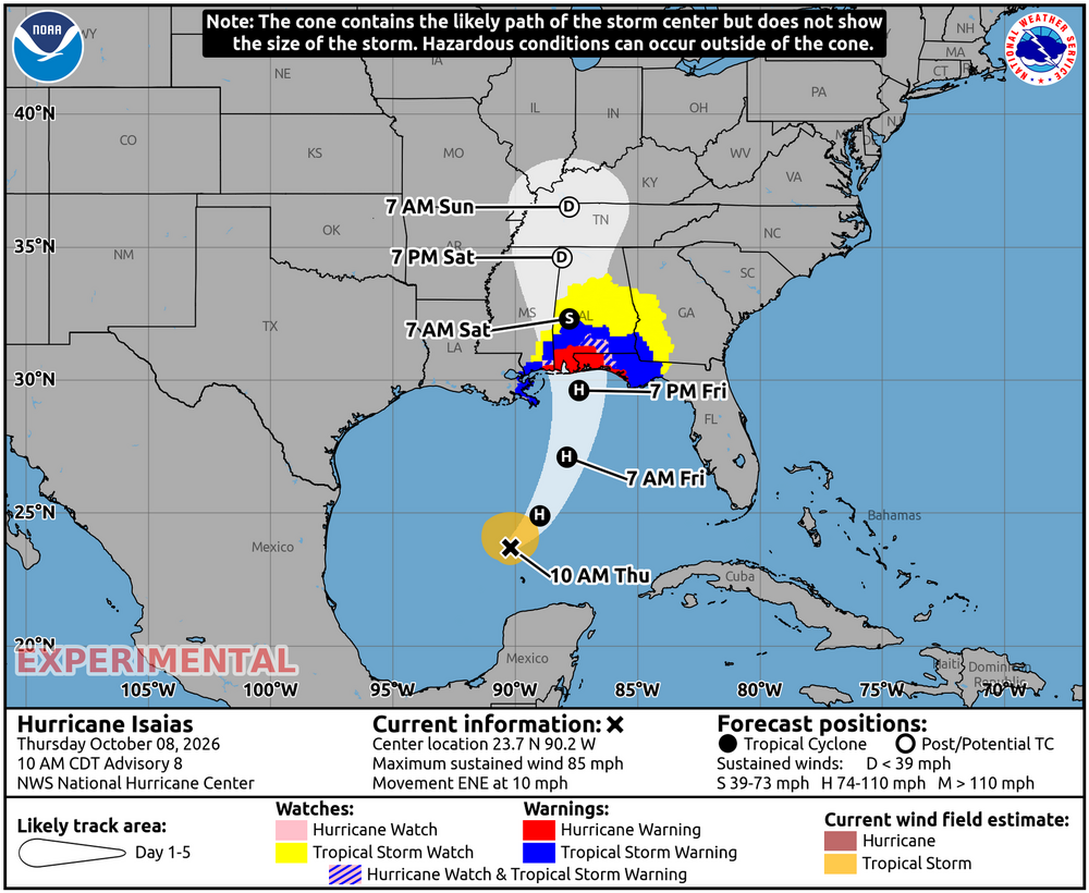
Tropical Storm watches well inland in AL/GA: This is for way up in C AL including Birmingham and Tuscaloosa: **TROPICAL STORM WATCH ISSUED FOR MUCH OF CENTRAL ALABAMA** * STORM INFORMATION: - ABOUT 710 MILES SOUTH-SOUTHWEST OF BIRMINGHAM AL OR ABOUT 640 MILES SOUTH-SOUTHWEST OF MONTGOMERY AL - 23.7N 90.2W - STORM INTENSITY 85 MPH - MOVEMENT EAST-NORTHEAST OR 60 DEGREES AT 10 MPH SITUATION OVERVIEW ------------------ HURRICANE ISAIAS WILL CONTINUE TO MOVE TOWARDS THE NORTHERN GULF COAST, MAKING LANDFALL FRIDAY EVENING. WINDS MAY GUST AS HIGH AS 40 TO 50 MPH LATE FRIDAY NIGHT THROUGH SATURDAY, RESULTING IN THE POTENTIAL FOR NUMEROUS DOWNED TREES AND POWER LINES. RAINFALL AMOUNTS OF 2 TO 4 INCHES WITH LOCALLY HIGHER AMOUNTS UP TO 5 INCHES WILL RESULT IN THE POTENTIAL FOR FLASH FLOODING, ESPECIALLY IN URBAN AND OTHER POOR DRAINAGE AREAS. A THREAT FOR ISOLATED TORNADOES MAY DEVELOP ACROSS PORTIONS OF CENTRAL ALABAMA ALONG AND EAST OF THE TRACK ON SATURDAY, WITH THE HIGHEST POTENTIAL ALONG AND EAST OF INTERSTATE 65. CONFIDENCE IS LOW TO MEDIUM AT THIS TIME.
-
Very impressive structure especially given the shear. If it maintains the current blow up of storms during the convective minimum that could allow significant intensification
-
Seems to be strengthening around the solar minima fighting back shear with convection then levels out as soon as convection starts to die down during the daytime.
-
Another pass with extrapolated 974 mb. Whatever strengthening that is happening isn't happening super quickly.
-
we are opening up national parks for drilling and mining
-
unskilled labor in the US is not expensive and our environmental and human rights protections have been substantially degraded over the past 2 years under a similarly tyrannical regime the petroleum business receives vastly bigger subsidies than renewables no it's not, i live in a house that has a solar energy system on the roof that produces more electricity on average than I use wind farms can be built near the coast; the coasts are where population is most concentrated
-
Plenty. You can find them here: https://www.nhc.noaa.gov/data/
-
Hurricane Isaias Advisory Number 8 NWS National Hurricane Center Miami FL AL092026 1000 AM CDT Thu Oct 08 2026 ...ISAIAS STRONGER... ...PREPARATIONS TO PROTECT LIFE AND PROPERTY FROM STORM SURGE AND DAMAGING WINDS IN THE WARNING AREA SHOULD BE RUSHED TO COMPLETION TODAY... SUMMARY OF 1000 AM CDT...1500 UTC...INFORMATION ----------------------------------------------- LOCATION...23.7N 90.2W ABOUT 170 MI...270 KM N OF PROGRESO MEXICO ABOUT 380 MI...610 KM S OF THE MOUTH OF THE MISSISSIPPI RIVER MAXIMUM SUSTAINED WINDS...85 MPH...140 KM/H PRESENT MOVEMENT...ENE OR 60 DEGREES AT 10 MPH...17 KM/H MINIMUM CENTRAL PRESSURE...975 MB...28.80 INCHES ———————— Hurricane Isaias Discussion Number 8 NWS National Hurricane Center Miami FL AL092026 1000 AM CDT Thu Oct 08 2026 Isaias is strengthening in an environment of moderate vertical wind shear. Observations from an Air Force Hurricane Hunter aircraft indicate that the central pressure continues to fall and the maximum winds are now near 75 kt. The center of the hurricane is near the southwestern side of a Central Dense Overcast feature, and some convective banding features are evident over the eastern portion of the circulation. Additional aircraft reconnaissance missions are scheduled for today, tonight, and Friday, so we will have close monitoring of the intensity of the system up until landfall. Center fixes from the Hurricane Hunters indicate that Isais continues on a generally east-northward track with an initial motion of about 060/9 kt. During the next 36 hours, the hurricane should gradually turn toward the northeast and north as it moves between a ridge extending from the Bahamas across the Florida Peninsula and a zonally-oriented mid-level trough near the northwestern Gulf coast. On the forecast track, the center of the hurricane is forecast to move across the east-central to northeastern Gulf coast in 36-42 hours. Thereafter, the weakening cyclone should move over the southeastern United States bringing strong winds well inland. The track guidance has not changed much for this advisory cycle and the official forecast is similar to that of the previous advisory. The intensity forecast up to landfall is somewhat challenging. On the one hand, the hurricane should move over waters of high oceanic heat content and within a fairly moist air mass through tomorrow. On the other hand, the SHIPS model input parameters show a significant increase in vertical wind shear, particularly when Isais nears the coast. Regarding, the shorter-term intensity forecast, a recent WSFM microwave satellite image at 37 GHz frequency shows a closed ring around the eye. This is typically a harbinger of rapid intensification. The 12-hour forecast does show a relatively large increase in strength, but in view of the expected stronger shear in 24-36 hours, some decrease in intensity is indicated as Isaias approaches the coast. Regardless, Isaias is expected to remain a dangerous hurricane through landfall, and gusty winds are expected well inland after landfall given the anticipated expansion of the wind field and accelerating forward speed of the storm. FORECAST POSITIONS AND MAX WINDS INIT 08/1500Z 23.7N 90.2W 75 KT 85 MPH 12H 09/0000Z 24.9N 89.0W 90 KT 105 MPH 24H 09/1200Z 27.1N 87.9W 95 KT 110 MPH 36H 10/0000Z 29.6N 87.4W 85 KT 100 MPH 48H 10/1200Z 32.3N 87.8W 35 KT 40 MPH...INLAND 60H 11/0000Z 34.6N 88.1W 30 KT 35 MPH...POST-TROP/INLAND 72H 11/1200Z 36.5N 87.8W 25 KT 30 MPH...POST-TROP/INLAND 96H 12/1200Z...DISSIPATED $$ Forecaster Pasch
-

2026-2027 Record-breaking El Nino
forkyfork replied to Stormchaserchuck1's topic in Weather Forecasting and Discussion
the west pac warm pool has been building for the past decade and now the entire thing has been ejected to east of the dateline. that has never happened in the observational record -
Heh...going below average is low probability - that's both epistemic to climatology, but then physically substantiated by empirical/objective data results over recent decade(s). There is questions about the nocturnal temperature behaviors. Yes. They tend to own our departure weight - why so is a matter of ongoing science. Probably just water vapor logistics and the fact that our region is basically the asshole of the continent. Daytime recoveries are where we are being enabled from having to admit certain things. Haha ... countless times since 2000, all signals modeled argued for below results from synoptic air masses, but then what really happened was a poorly predicted cloud and/or precipitation timing that forced a cooler at that end of the diurnal cycles. The end result was more like 'colder relative to the recent mode' while not really being colder than 30-year norms. Then we do get a below normal pop here and there... but if we get it, there is an under the radar sort of behavior note on all of them that they don't last. In the 1980s... a massive arctic intrusion would happen, then it would take 7 to 10 days to recover to normal. Now, we get Feb 2021ers where it is -9 F at 1pm with 22 mph wind gust, and just two days later ... it's 40 and above normal. Then it is 40 for 5 days significantly offsetting if not erasing the deep incursion event entirely. Climatology as moving goal post is a facet that apparently most acknowledge but I sense not enough use or allow to modulate impressions of the future. So the crowd and consensuses tend more so than not, to sag below the result curve. I see that from just about every source... I read qualifiers like, ' aware of this and that regarding climate'. Then my internal monologue interrupts that reading voice with, 'but if that's true it would be unwise to think the proceeding' so it's not clear the +delta aspect of the climate system et al is sufficiently modulating - this is evidence spanning all of society - not just in here. No one's getting singled out...
-
Many examples. Milton most recently
-
2026-2027 Record-breaking El Nino
forkyfork replied to Stormchaserchuck1's topic in Weather Forecasting and Discussion
nope. no luck. good patterns produce good outcomes and bad patterns produce bad outcomes -
Can you tell me what were other times that a hurricane formed in that general area after start of October? Thanks
-
It was a wee bit chilly yesterday in the woods being 28°F, Heavy frost/freeze here.
-

Winter 2026-2027 Seasonal Outlook
WinstonSalemArlington replied to WinstonSalemArlington's topic in Southeastern States
This was Accuweather's forecast for last winter: -
Winter 2026-2027 Seasonal Outlook
WinstonSalemArlington replied to WinstonSalemArlington's topic in Southeastern States
-
Full moon goon to new moon goon. Two weeks later the biggest goon of them all.
-

2026-2027 Record-breaking El Nino
40/70 Benchmark replied to Stormchaserchuck1's topic in Weather Forecasting and Discussion
I don't mean this to be insulting, either....I have had some brutal forecasts....anyone being honest and transparent has. -

2026-2027 Fall/Winter Mountain Thread
strongwxnc replied to BlueRidgeFolklore's topic in Southeastern States
High end totals out of GSP Forecast totals -

2026-2027 Record-breaking El Nino
OSUmetstud replied to Stormchaserchuck1's topic in Weather Forecasting and Discussion
I deleted that because the RONI/ONI standard deviations for OISST and ERSSTv6 are very similar which means it must have been scaled despite the differences.