All Activity
- Past hour
-

2026-2027 Record-breaking El Nino
JVscotch replied to Stormchaserchuck1's topic in Weather Forecasting and Discussion
I thought the MJO was the biggest factor, as MJO went through phases 4-6 in December which amplified the warmth. The MJO has heavily been absent from these phases since summer. If somehow we manage to hit them, then sure. -

2026-2027 Record-breaking El Nino
forkyfork replied to Stormchaserchuck1's topic in Weather Forecasting and Discussion
and this nino is a steroid injection -
Andrej / severe-weather.eu @Recretos · 10m https://x.com/Recretos/status/2115073153533653480 With a lot of talk about the upcoming Polar Vortex disruption and a potentially official SSW (Stratospheric Warming) event, most people cant see what makes this event "unprecedented" as its often called. And for a good reason, as a single map of the #polarvortex can be vague in context. I decided to visualize that context. The official criteria for an SSW event is the reversal (0 or negative value) of the stratospheric winds at the 10mb level along the 60N polar circle line. We are still on the edge if we will reach a reversal with this event, but there are forecast runs that suggest its likely. Link to those live forecasts is in the comments Most of the SSW events occur in January and February. I decided to look at every first SSW of each season (some seasons had two) and when it occurred. As you can see, a reversal in the current event would break the record for the earliest SSW on date by at least 3 weeks! This is really a strong outlier, and having an SSW this early in the season is what makes this event unprecedented in itself, perhaps more so than any temperature or pressure anomaly in the stratosphere. Its likely not a coincidence we get this with a very strong Super El Niño ongoing in the Pacific. So overall, this is truly a very interesting season for anyone that is into monitoring the weather and seasonal development.
-
BAM Weather @bam_weather A #polarvortex split at this point is likely not if but when. This will have significant implications to the 2nd half of NOV and likely introduce much colder risks to the outlook. We will have a full detailed breakdown out to BAM clients today with our updated 3-4 week outlook. Excellent plots @Recretos thank you.
-
2026-2027 Record-breaking El Nino
forkyfork replied to Stormchaserchuck1's topic in Weather Forecasting and Discussion
how is dec 2015 so unreasonable if the climate has warmed since then and this nino is stronger? -

2026-2027 Record-breaking El Nino
Keith Central PA replied to Stormchaserchuck1's topic in Weather Forecasting and Discussion
Maybe because your pushing December 2015 with +10 and others here are more sensible and realistic. A December +3-+5 is more in line with 72,82, and 97..than the extreme iof 2015. . -
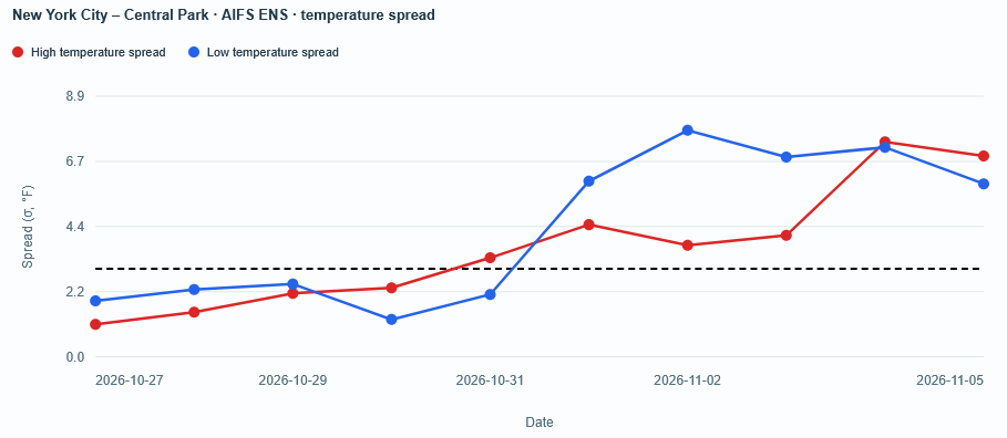
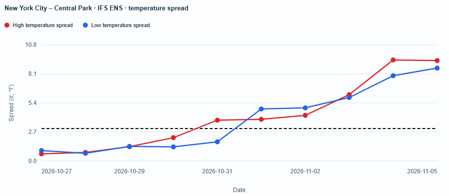
The AIFS ensembles are particularly warm for the first week of November. The regular ECMWF ensembles are still warm (highs in the 60s), but cooler than their AI counterparts. The extended range of the NBM is also closer to the regular ECMWF ensembles. Both sets of ECMWF ensembles have high spreads (uncertainty), especially after November 3. However, the uncertainty concerns the magnitude of warmth, not whether it will be warmer than normal. The idea of a warmer than normal start to November has been a recurrent theme on the guidance. The most recent ECMWF weekly guidance is below.
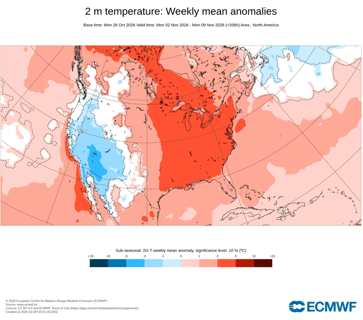
-
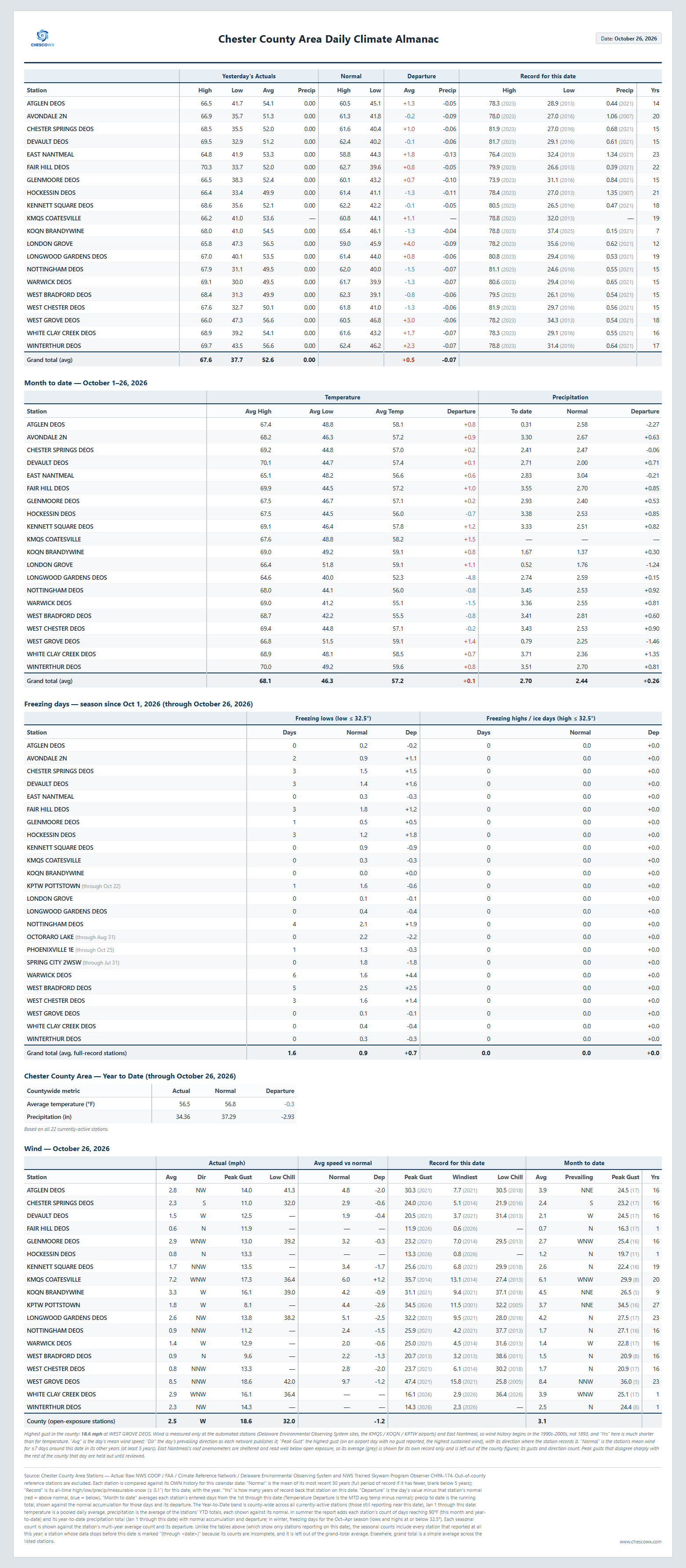
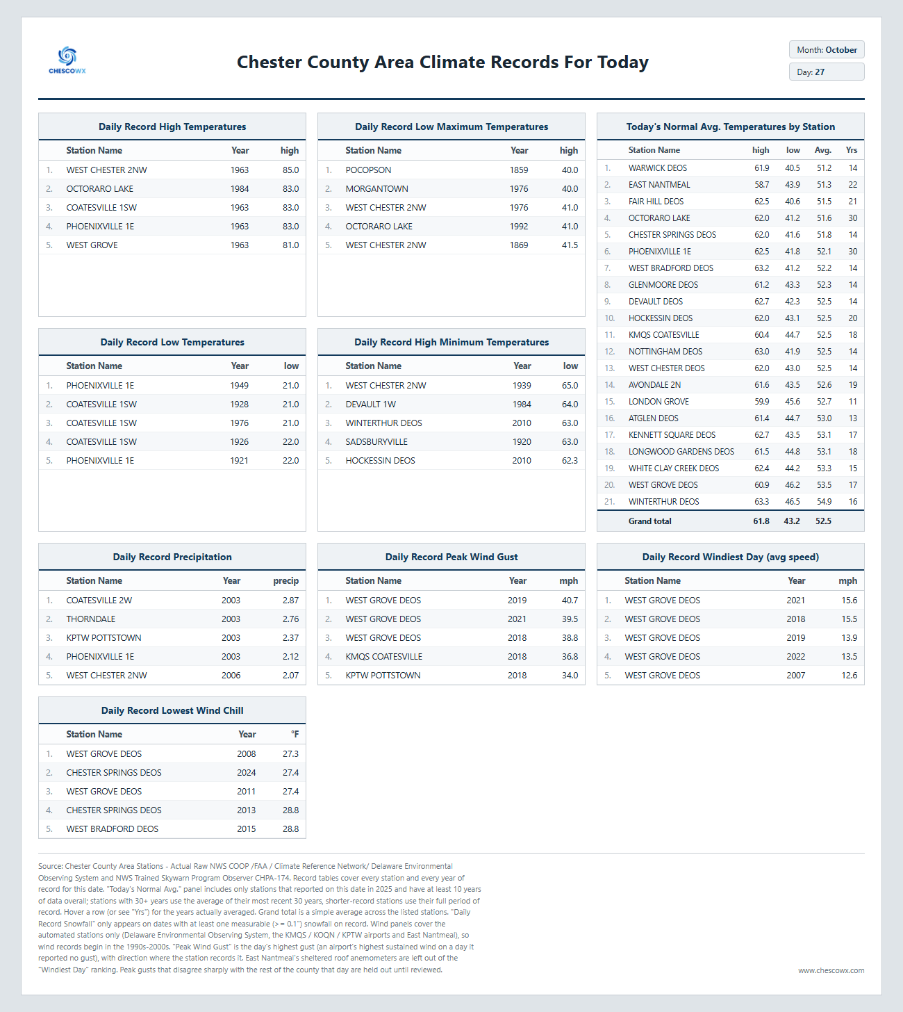
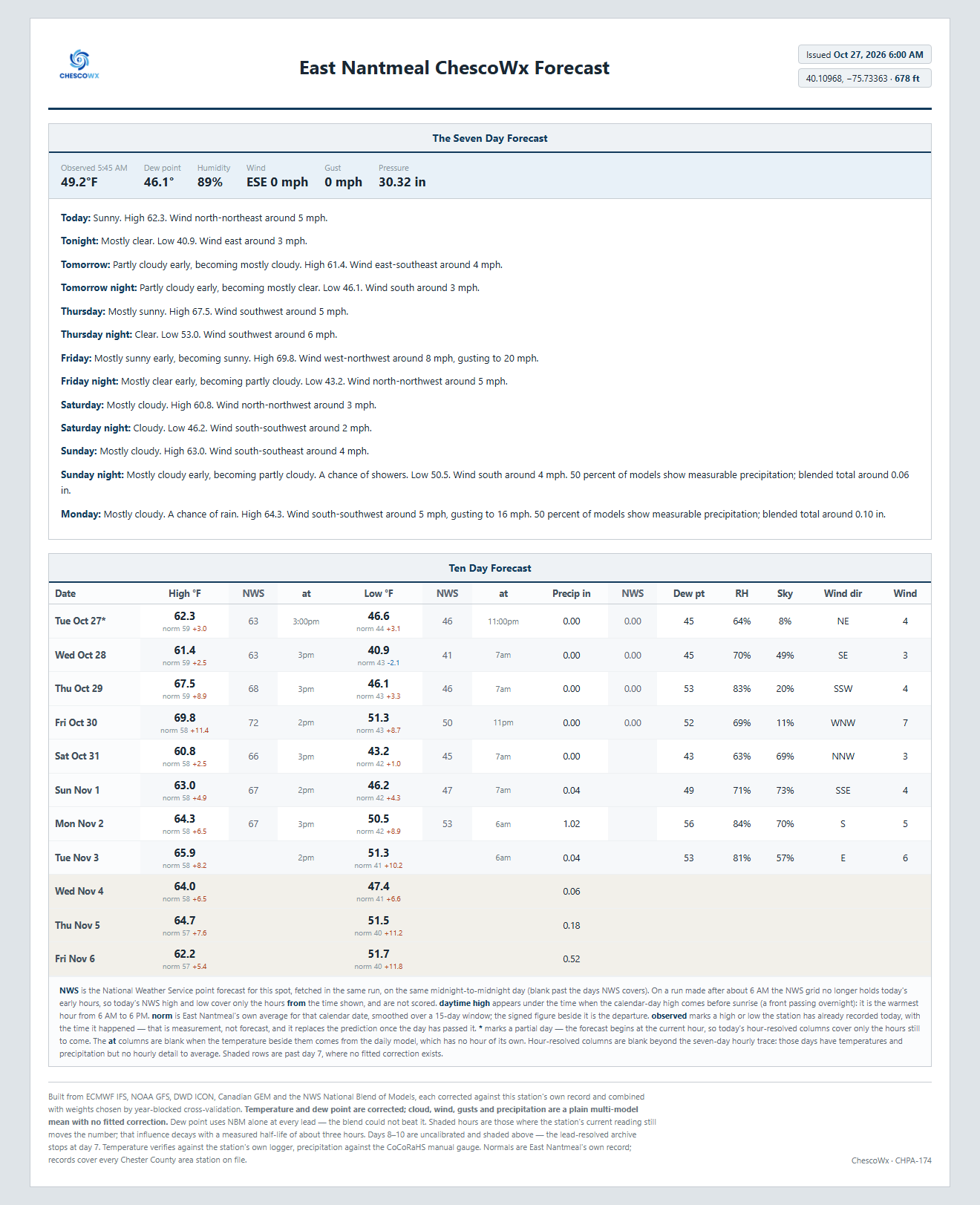
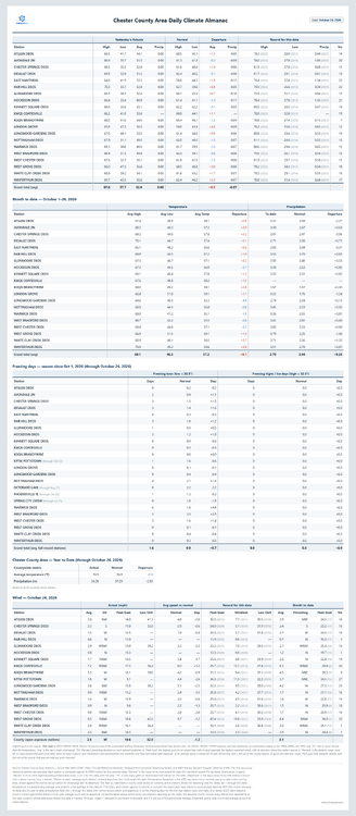
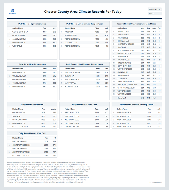
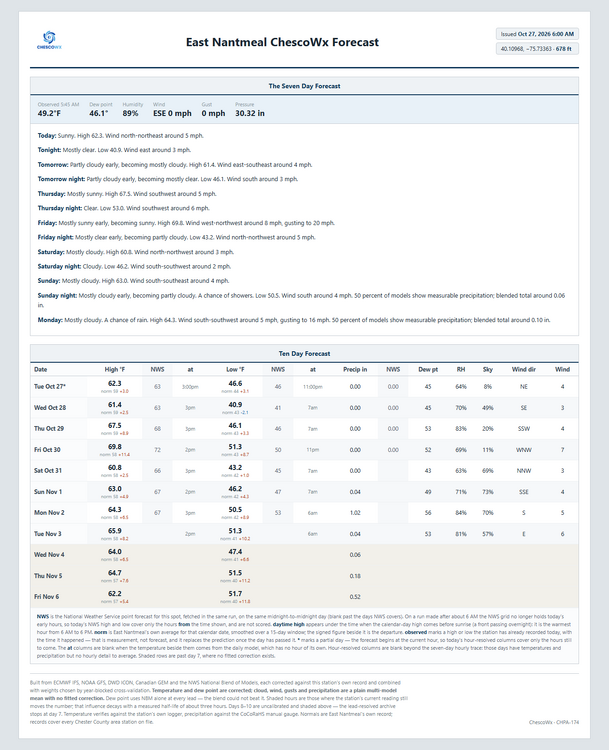
Today we should see highs from low 60's in ridge locations to the mid 60's in valley spots. This is about 3 degrees above normal with lows tonight in the mid 30's to low 40's. Temperatures will be near normal Wednesday but by Thursday and Friday we warm to near 70 degrees which is 6 to 10 degrees above normal, before we return to near normal by Saturday. It has been a while since our last rain but our next soaking rain looks to arrive Monday with around 1.0" possible according to the ChescoWx model. Of note 14 years ago today back in 2012 the Chester County Area was at the start of a 4 day storm that left as much as 6.16" of rain at West Chester 2NW. This was the remnants of Hurricane Sandy which tracked within about 20 miles of the county.
-

E PA/NJ/DE Autumn 2026 Obs/Discussion
ChescoWx replied to PhiEaglesfan712's topic in Philadelphia Region
Today we should see highs from low 60's in ridge locations to the mid 60's in valley spots. This is about 3 degrees above normal with lows tonight in the mid 30's to low 40's. Temperatures will be near normal Wednesday but by Thursday and Friday we warm to near 70 degrees which is 6 to 10 degrees above normal, before we return to near normal by Saturday. It has been a while since our last rain but our next soaking rain looks to arrive Monday with around 1.0" possible according to the ChescoWx model. Of note 14 years ago today back in 2012 the Chester County Area was at the start of a 4 day storm that left as much as 6.16" of rain at West Chester 2NW. This was the remnants of Hurricane Sandy which tracked within about 20 miles of the county.
-
Ride or die with this (probably dying)
-
Ensembles look pretty wet starting next week. Globals habe been bouncing around but starting to settle in on idea of multiple systems
-

2026 Atlantic Hurricane Season
PhiEaglesfan712 replied to Stormchaserchuck1's topic in Tropical Headquarters
The season is done. It's almost impossible to get a named storm in November during an el nino. We couldn't even get one in November in 2023, and that season had 20 storms. 2 named storms and another hurricane is wishful thinking, especially in a season that's been very quiet. Maybe in the Pacific basin, but not in the Atlantic. -

2026-2027 Record-breaking El Nino
40/70 Benchmark replied to Stormchaserchuck1's topic in Weather Forecasting and Discussion
I think the elimination of the ample MC forcing from 2023-2024 helps. Strat warming is pretty varied in how it manifests so it's tough to say outside of the fact that it is probably too early at this point. -
Boredom until 2027 severe season?
-
 https://canpointerx.com/# canada pharmacy
-

2026-2027 Record-breaking El Nino
bluewave replied to Stormchaserchuck1's topic in Weather Forecasting and Discussion
Last winter was a weak La Niña and the SSW occurred in late November. This early PV disruption is occurring nearly a month earlier before the vortex fully sets in. Plus it’s forecast to rebound pretty quickly. So the amount of potential cold air is going to be fairly limited this early in the season especially against the record Northern Hemisphere temperatures in association with the historic super El Niño. We didn’t have much success with the two SSWs during a much weaker super El Niño in January 2024 and March 2024. Also the weak PV during January 1998 actually enhanced the warmth when the -AO linked up with the Southeast ridge.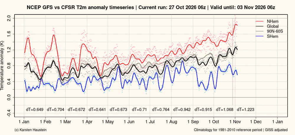
-
Yellow Medicine County, MN - Climate Fact or Climate Fiction?
ChescoWx replied to Cobalt's topic in Climate Change
No evasiveness just want to see the deeper details and actual figures calculated that support these decades later adjustments to the raw data. I am a numbers guy by training so love digging into the supporting calculations that will support the adjustments. -
48 overnight
-

2026-2027 Record-breaking El Nino
Lucy Pull replied to Stormchaserchuck1's topic in Weather Forecasting and Discussion
With the way forcing has been setup I’m feeling a warmer version of December 1997 than 2015. All bets off if we pop an eastern ridge and it connects with the Canadian ridge. -

2026-2027 Record-breaking El Nino
MJO812 replied to Stormchaserchuck1's topic in Weather Forecasting and Discussion
No one wants cold now anyway -
p typical spready for klot
- Today
-
2026-2027 Record-breaking El Nino
40/70 Benchmark replied to Stormchaserchuck1's topic in Weather Forecasting and Discussion
I think it's too early to mean much for us, even if it does result in a colder period. -
2026-2027 Record-breaking El Nino
40/70 Benchmark replied to Stormchaserchuck1's topic in Weather Forecasting and Discussion
I think I have made it clear that I am skeptical of how impactful this strat warming will be and am more interested in what it may portend later in the season. -
Was outside with the dog around 8:00 or so last night and was surprised how mild it still was.
-
2026-2027 Record-breaking El Nino
40/70 Benchmark replied to Stormchaserchuck1's topic in Weather Forecasting and Discussion
It's almost as if the climate is warming or something...