All Activity
- Past hour
-
Almost died on the way home and not from the weather. Felt something crawl across my arm and neck and swept my hand across my face and look on my door and it was a giant spider...swerved and almost crashed trying to pinpoint it...thats when I saw it was massive. Luckily I had a tissue so I got it. also about a mile from home there was a part of a road that was pretty flooded...didn't see it until too late and my car squealed loudly all the way home.
-

Saturday 9/6 Strong/Severe storm potential
Baroclinic Zone replied to Torch Tiger's topic in New England
Hearing the rumbles of the distant storms -
Heh... I think a couple of the models nailed the initial cells just skirting to my north and west and that's just what they are doing. Cool it's so dark here.
-

Saturday 9/6 Strong/Severe storm potential
Torch Tiger replied to Torch Tiger's topic in New England
Def bolt from the blue potential, headsup lol -
Saturday 9/6 Strong/Severe storm potential
Torch Tiger replied to Torch Tiger's topic in New England
Crazy +cg's -
Enough rain to actually make puddles and get under the trees wet. First time since mid August here in silver spring.
-

September 2025 OBS-Discussion centered NYC subforum
psv88 replied to wdrag's topic in New York City Metro
Pouring now, this is probably our batch to get 1/2” -

September 2025 OBS-Discussion centered NYC subforum
allgame830 replied to wdrag's topic in New York City Metro
Looks like that rain to the south over the Delmarva is more aimed towards LI and southern parts of the metro. I could be wrong but that’s what it looks like -

September 2025 OBS-Discussion centered NYC subforum
donsutherland1 replied to wdrag's topic in New York City Metro
Today saw the temperature top out at 90° at Newark and strong thunderstorms bring drenching rainfall to parts of the region. Newark reached 90° or above in June, July, August, and September for the first time since 2023. 2023 also saw the mercury hit 90° in May, unlike this year. Hourly rainfall amounts included: Central Park: 0.89", LaGuardia Airport: 0.78"; and, White Plains: 0.90". Today is Central Park's wettest day since 2.64" fell on July 14. A cold front crossing the region will bring additional showers and thundershowers tonight. Rain could linger into tomorrow as the front slows. A general 0.50"-1.50" rainfall is likely around the New York City area and its nearby suburbs with localized amounts in excess of 2.00" by the time the rain ends tomorrow. Following the passage of the cold front, highs will reach the upper 60s to lower 70s tomorrow. Afterward, temperatures will mainly top out in the 70s during the daytime and fall into the 50s at nighttime in New York City through at least the middle of next week. Additional showers or rain is possible around midweek. The ENSO Region 1+2 anomaly was -0.3°C and the Region 3.4 anomaly was -0.4°C for the week centered around August 27. For the past six weeks, the ENSO Region 1+2 anomaly has averaged +0.33°C and the ENSO Region 3.4 anomaly has averaged -0.32°C. La Niña conditions will likely develop during mid- or late-autumn. The SOI was +17.47 today. The preliminary Arctic Oscillation (AO) was -0.837 today. -
Danger
-
Saturday 9/6 Strong/Severe storm potential
Torch Tiger replied to Torch Tiger's topic in New England
Having a few power flickers and I am on a main line. Also torrential rain, probably .75" by now easy -
Had nearly an hour of mod/hvy RA, barely enough thunder to call it a TS - 1st one since July 20. Not close to severe (near zero wind) but we take.
-

Saturday 9/6 Strong/Severe storm potential
SouthCoastMA replied to Torch Tiger's topic in New England
Always, and it never gets old. -
Line meh now
-
I've been saying all along that there was just too much SAL out there for development.
-
Some more broad rotation with the line on the MA/CT line
-
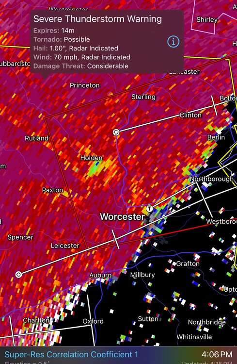
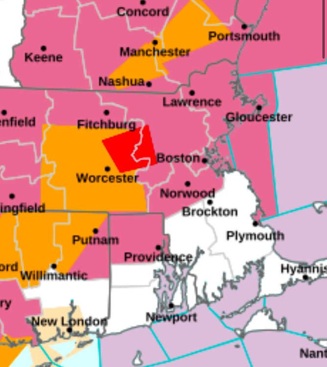
How Many Tornado Warnings do we get a Year? Maybe 1 in the entire region??
-
Rain! Got the outflow boundary intersection just right. Over 0.50” in a day for the first time since mid-July.
-
Trying again near Nokesville/Bristow area?
-
Getting a few rumbles with darkening skies. Hopefully it'll hold together.
-
Starting with Kevin ?
-
That's it? Gosh I thought you were going to get more then that, maybe tomorrow?
-
I've never considered the sky from a grasshopper's perspective before. Fascinating.
-
Saturday 9/6 Strong/Severe storm potential
Torch Tiger replied to Torch Tiger's topic in New England
definitely an embedded sup in there. Was getting anvil lightning from that 20 minutes ago, same thing now. Very impressive even missing it -
TDS?