All Activity
- Past hour
-

E PA/NJ/DE Autumn 2025 Obs/Discussion
Birds~69 replied to PhiEaglesfan712's topic in Philadelphia Region
Some junk around...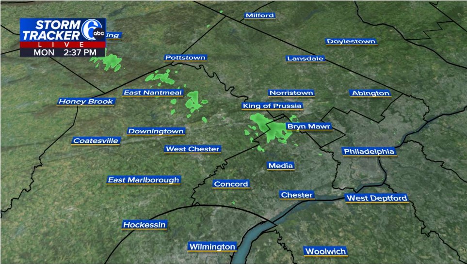
-

November 2025 general discussions and probable topic derailings ...
Hazey replied to Typhoon Tip's topic in New England
With CC putting early snows further out of reach, the focus should be on the holidays. See if we can get snow for Christmas. Might still have a shot there. -
E PA/NJ/DE Autumn 2025 Obs/Discussion
Birds~69 replied to PhiEaglesfan712's topic in Philadelphia Region
Looks like something out there. Winds still doing their thing, dark clouds. I may go trashcan chasing tonight...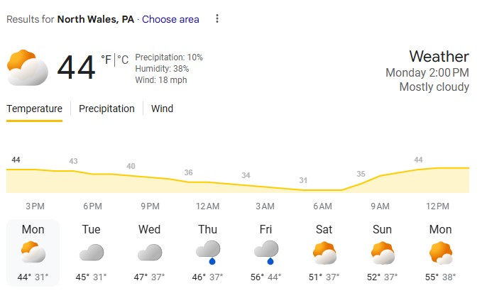
-

November 2025 general discussions and probable topic derailings ...
dendrite replied to Typhoon Tip's topic in New England
Can’t divide by zero -

November 2025 general discussions and probable topic derailings ...
tamarack replied to Typhoon Tip's topic in New England
Fort Kent snow probably settled some. ...Aroostook County... 3 WNW Blaine 10.3 in 0636 AM 11/17 Trained Spotter 2 SSW Easton 9.0 in 0445 AM 11/17 NWS Employee 2 SSE Castle Hill 8.9 in 0700 AM 11/17 COCORAHS 3 NW Monticello 7.8 in 0507 AM 11/17 Trained Spotter 1 WNW Ashland 7.7 in 0708 AM 11/17 1 NW Presque Isle 7.5 in 0803 AM 11/17 NWS Employee 4 SW Stockholm 7.0 in 0830 AM 11/17 Public 2 ENE Presque Isle 7.0 in 0830 AM 11/17 Public 1 WSW Madawaska 6.8 in 0454 AM 11/17 Trained Spotter Fort Kent 1 SE 6.5 in 0700 AM 11/17 COOP Caribou NWS 6.0 in 0700 AM 11/17 COOP 1 SE Fort Kent 6.0 in 0715 AM 11/17 Trained Spotter Perham 6.0 in 0800 AM 11/17 Public 4 NNE Caribou 5.8 in 0715 AM 11/17 NWS Employee 2 NE Fort Fairfield 5.0 in 0601 AM 11/17 NWS Employee 1 NNW Macwahoc 5.0 in 0745 AM 11/17 Trained Spotter 4 NW Caribou 3.8 in 0630 AM 11/17 Trained Spotter 4 WSW Fort Fairfield 3.5 in 0715 AM 11/17 Trained Spotter Houlton 3.3 in 0836 PM 11/16 Trained Spotter 1 WNW Caribou 3.2 in 0919 PM 11/16 NWS Employee Frenchville 3.0 in 0500 PM 11/16 Public Van Buren 1 NNE 3.0 in 0630 AM 11/17 COOP 4 SE Washburn 2.0 in 0500 PM 11/16 Trained Spotter -

November 2025 general discussions and probable topic derailings ...
CoastalWx replied to Typhoon Tip's topic in New England
I would just like to see the PV more towards Hudson Bay to spread the cold a little bit further east. I think there might be a better chance for more eastern Canada cold after the 5th like you said. -
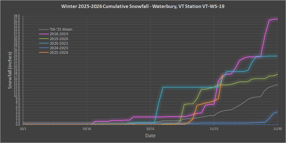
Your estimate was good - with the addition of this latest storm, that’s about where we are. I just added another past season to the current snowfall progress plot – I hadn’t yet added 2018-2019 because it was a slower start than some of the others, but we’re up to the part of the month where it got going and became relevant, so it’s on there in pink. What’s notable is that this season’s snowfall just snuck above the 2018-2019 season for this date by a tenth of an inch to claim the top spot. Snowfall is essentially running neck-and-neck with that season though, with 2020-2021 right in there as well. It would take a continued strong snowfall performance for this November to be able to hang with those for the second half of the month, but the modeling suggests at least some snow chances, so we’ll see what happens.
-

November 2025 general discussions and probable topic derailings ...
weatherwiz replied to Typhoon Tip's topic in New England
It's not worry, it's analysis, assessment, and questioning. There is way too much emphasis and focus on extended range EPS signals and not enough focusing on real time observations (current state/pattern) and evolution of the short term pattern to look for those signals which may begin driving the pattern. Patterns just don't magically change and don't magically change. There are typically day-to-day nuisances which will determine how the pattern unfolds and behaves. For example, let's say forecast models were showing a drastic change say D6 or D7 (even D5)...we would be able to see in the next day or two those pieces which will be responsible for the change and determine in the short term the validity of this change instead of chasing D10 EPS means. -
November 2025 general discussions and probable topic derailings ...
CoastalWx replied to Typhoon Tip's topic in New England
Yeah, that far out ensembles can be wrong, but I think that applies especially getting details like low pressure locations, etc. versus a 500 MB pattern. However, I don’t think there’s anything wrong with accepting that it could be mild next week. This is your classic EPO dump that always goes out west and in the plains first, and that implies a ridge over the east. So you also have Climo on your side along with the ensemble prediction. I don’t think that is unreasonable. -
 that EPO isn't a waste, though. always good to have Arctic air nearby so you get a quick flip and cold source region
 -
What a breathe of fresh air.
-

November 2025 general discussions and probable topic derailings ...
WinterWolf replied to Typhoon Tip's topic in New England
I think you worry too much. -
That’s awesome. Happy for you guys.
-
E PA/NJ/DE Autumn 2025 Obs/Discussion
Birds~69 replied to PhiEaglesfan712's topic in Philadelphia Region
AW super accurate stuff....at least it's cold.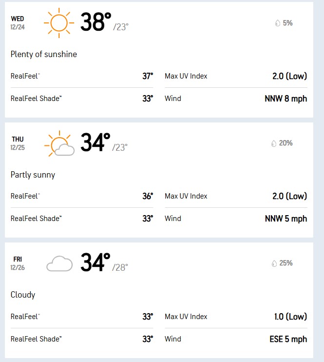
-
November 2025 general discussions and probable topic derailings ...
WinterWolf replied to Typhoon Tip's topic in New England
I understood that part…and as I said, I agree. But these ensembles haven’t been anything to brag about either…so I guess that was more my point. -
November 2025 general discussions and probable topic derailings ...
weatherwiz replied to Typhoon Tip's topic in New England
Overall (at least 12z) the not much difference between the Euro/GFS ensembles outside of strength of key features and placement of the main anomaly centers but that is a warm look overall but can't dismiss any wedge potential like Scott said. But I don't really like the way the pattern is configured overall to elicit some big magical changes going through the first week of December. I think we'll certainly see some colder periods, like we've seen this month, but they are brief and more transient. There are multiple things we're fighting 1) Persistent evolution of lower heights and deep troughing across the West 2) A stout subtropical ridge which is flexed into the Southeast as those troughs amplify and dig into the west 3) Even with a -NAO look at times, which helps to bring in that colder air (for a brief period) you always have to watch for connecting heights across the east. Maybe things break down a bit moving through the first week of December but we're going to want to see something in real time (like in 7-10 days) that is in place that will not trigger it...not the it will change because it looks better at D10 ordeal -
November 2025 general discussions and probable topic derailings ...
WinterWolf replied to Typhoon Tip's topic in New England
Ya think? Maybe? I was looking at the back of the sled-behind the seat on the tunnel…that looked more like 4” to me. Gotta be careful because that sleds seat has a slight bulge towards the middle..so that may make it look like more snow there. But nonetheless, it was a substantial event up there. -
November 2025 general discussions and probable topic derailings ...
CoastalWx replied to Typhoon Tip's topic in New England
When I say way different, getting a 500 MB pattern correct versus getting a solution like a low passing just south of you to give you snow, is way different. It is much easier to show a ridge over the East Coast 11 days out on an Ensemble versus getting specific details on an area of low pressure. It’s really apples to oranges. That’s why I mean way different. -
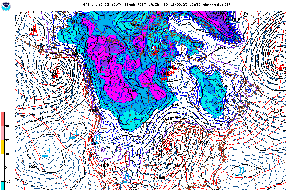
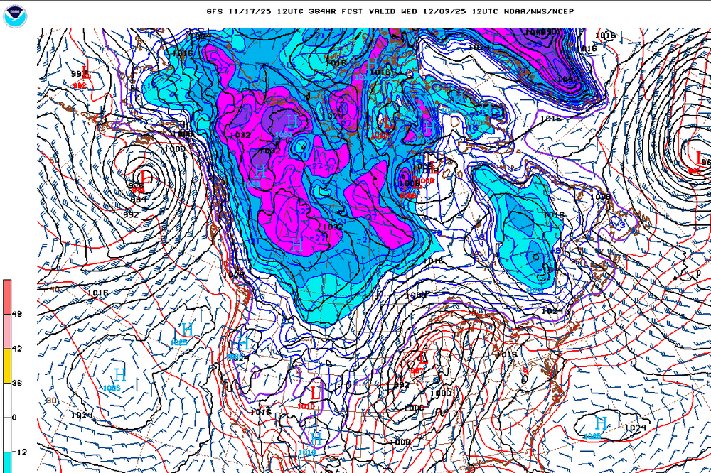
Euro has major Canadian cold in fantasy land
-
When was the last time they were right?.
-
November 2025 general discussions and probable topic derailings ...
CoastalWx replied to Typhoon Tip's topic in New England
Yep agree -
Are you like 15 years old or something and don't remember past 4 years ago? Central park from 1970-2002 only had 4 winters above 30". Go look up some stats.
-
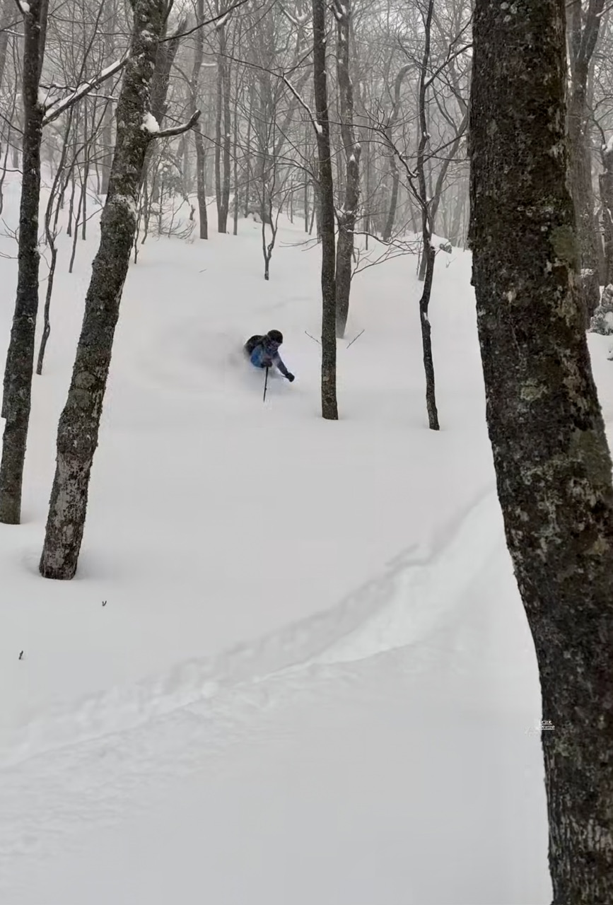
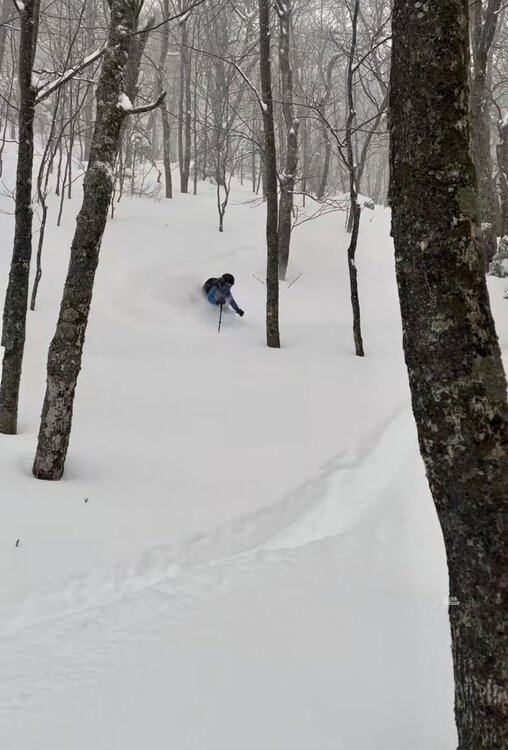
I’ve been too busy to ski it today so far but the content coming out of the woods around here is crazy for 11/17. 10” on top of the rain crust and all is good again.
-
Lots of cold air finally filling up Western Canada. Does not always mean it comes into the SE as we've seen the last few years but for any chance at BN, Canada has to be super cold. Hopefully that ridge can get tamped down and the trough axis moves east with time.
-
Thread: