All Activity
- Past hour
-
WB 6Z AI EPS Dec 8. Few hits starting to show up as early as Dec 4.

-

November 2025 general discussions and probable topic derailings ...
Spanks45 replied to Typhoon Tip's topic in New England
20.3⁰ for the low, coldest of the season. Everything is frozen, looks nice with the sun coming up. Clouds are beginning to roll in, going to make for quite the chilly day. -

November 2025 general discussions and probable topic derailings ...
CoastalWx replied to Typhoon Tip's topic in New England
Let’s get a GFS landfalling cane. -
It’s good that all of us using different methods had a weaker PNA for this December than the record +PNA La Niña mismatch last December following the stronger amplitude MJO 5 over +2.70 in October 2024.
-
November 2025 general discussions and probable topic derailings ...
CoastalWx replied to Typhoon Tip's topic in New England
Been meh morning lows. No real arctic shots. -

November 2025 general discussions and probable topic derailings ...
Kitz Craver replied to Typhoon Tip's topic in New England
Nothing too exciting through the runs for SNE… -

December 2025 Short/Medium Range Forecast Thread
Holston_River_Rambler replied to John1122's topic in Tennessee Valley
Pretty nice run of the Euro AIFS at 6z. -

November 2025 general discussions and probable topic derailings ...
WinterWolf replied to Typhoon Tip's topic in New England
23 here…coldest so far-many below freezing mornings this autumn. -
 21F here. So close to 1st teems. Coldest AM thus far this cold season.
 -

November 2025 general discussions and probable topic derailings ...
dendrite replied to Typhoon Tip's topic in New England
Min 25.6° Lots of mid level clouds. -
Amazing work to all involved in the project.
-
If Paul Roundy is correct, the 2nd half of December is going to have more -PNA/RNA than the 1st half
-
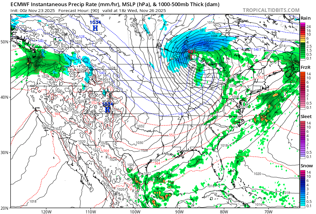
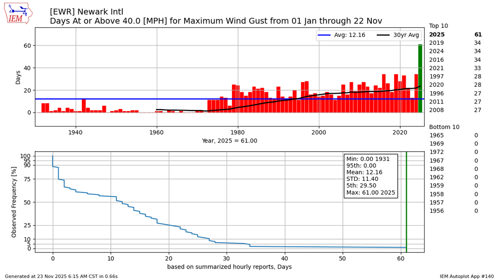
I guess it will be fitting that Thanksgiving is set to follow the same windy pattern we have seen all year. Mild Great Lakes cutter storm track on Wednesday. Then strong W to NW flow on Thursday. The one hope is that the strongest winds of around 40 mph peak after parade time. But you can see this year already has double the number of 40 mph gust days as any previous year at over 60. Most of the gusts since January have occurred behind Great Lakes or hugger storm tracks on W to NW flow. The one lone coastal storm back in October was one of the few days with a NE gust over 40 mph.

-

2025-2026 ENSO
Stormchaserchuck1 replied to 40/70 Benchmark's topic in Weather Forecasting and Discussion
-
Five star review. Love being able to check out any storm or winter season with the click of a button.
-
27F, coldest thus far…and unexpected
-
2025-2026 ENSO
Stormchaserchuck1 replied to 40/70 Benchmark's topic in Weather Forecasting and Discussion
You don't do well in ++NAO/-PNA either We may have to wait until the 2nd half of December for snowfall. -
2025-2026 ENSO
Stormchaserchuck1 replied to 40/70 Benchmark's topic in Weather Forecasting and Discussion
2m temps are probably too low given the Aleutian High pressure and neutral H5 over Alaska Dec 5-> -

Central PA Fall Discussions and Obs
pawatch replied to ChescoWx's topic in Upstate New York/Pennsylvania
29 degrees heavy frost this morning. Wind going to pick back up. -
The long range EPS generally underestimates the Pacific Jet and the forcing near the Maritime Continent. So both those factors lead to a stronger Southeast ridge. Plus it makes it challenging to get a clean MJO 8 pattern with forcing lingering there.
-
I'm very excited to share this massive project i've been working on since the end of last winter. I was going to wait until it was basically done but Seymour Snow kinda let the cat out of the bag yesterday, which is totally fine...the site's been live. We now have a winter storm archive with every moderate 3"+ event from last season back to 1994 complete with snowfall maps for Southern New England, Tri-State and CT as well as a full radar animation and surface and H5 maps. There's over 270 storms in the archive. I'm currently in the middle of the 95-96 season and updating the site almost daily. Winter Storm Archive The significant (12"+) storms have their own page to easily view at a glance if you only want to see the big ones and don't remember when they were in the archive. I've added additional related images, satellite, radar and more to these larger events. Historic Storms Archive There's also a section for only the snowfall maps sorted by region then by winter season (back to 94-95). Just go to the area you want to view, Southern New England, Tri-State Area or CT then click on the winter season you want. There's additional snowfall maps here that aren't in the archive that are either less than 3" or ones that only affected northern MA or southern NJ. Here you can also sort by 12"+, 24"+ or early/late season storms. Snowfall Maps Archive 25-26 events and maps will be added to the archive as they happen for the upcoming season. There's already 2 minor events in the Southern New England section. Will was a huge help with providing some archive sites like NCEP and Cornell Climodv2. All maps use data from COOP, cocorahs, NWS PNS and here. Everything is free and we don't run any ads. There's a download button on the images if you want to save them. As i mentioned the site is continuously being updated and added to. I'll probably do a thread like last year for all the SNE snowfall maps for all events. This was a huge passion project that i started years ago but really ramped it up this year so i hope yall enjoy it and find it useful.
-
November 2025 general discussions and probable topic derailings ...
CoastalWx replied to Typhoon Tip's topic in New England
27 here. -
This kept happening over and over again with the EPS in the long range back in 23-24
-
Got down to 29. 18z NAM from yesterday just missed that with a forecast low of 44.
- Today
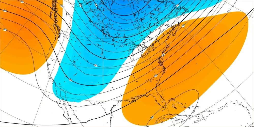
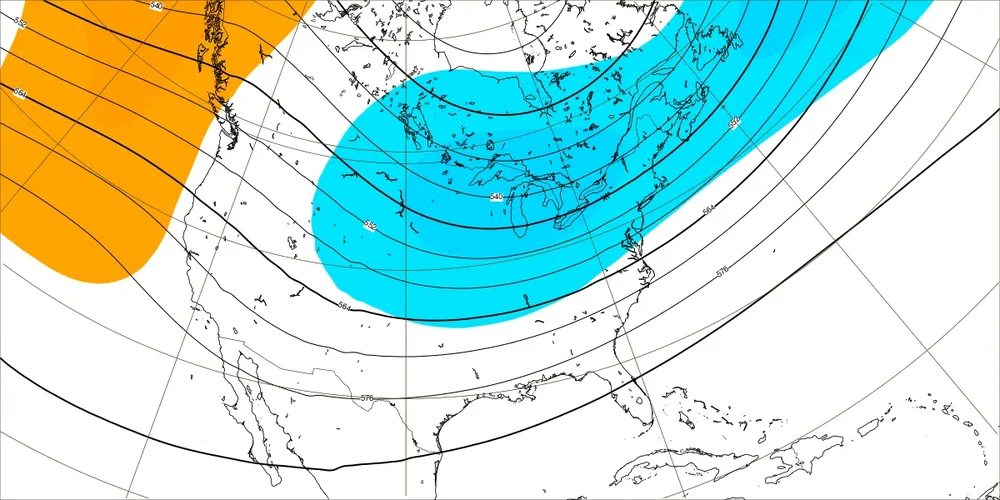
-
The more +NAO following the wave reflection in concert with the stronger Maritime Continent forcing will both act to enhance the Southeast ridge as we had into December. Remember, the original forecasts for the first week of December didn’t have any Southeast ridge. Models regularly underestimate the Southeast ridge influence in the long range. Either through the 5 day means or with the storm track which amplifies the Southeast ridge on the days of the storms. New EPS December 1-8 forecast Old EPS December 1-8 EPS forecast