All Activity
- Past hour
-

December 2025 regional war/obs/disco thread
weatherwiz replied to Torch Tiger's topic in New England
I legit am nervous. I know its early, but in the grand scheme of things, we're already assessing how the pattern looks to evolve post Christmas into New Years. If that period ends up sucking then we'll be looking towards mid-January...and so forth. I truly believe we need to completely flush out the entire atmosphere...we probably need a good multi year stretch where ENSO is a non factor and then hope we are truly on the -PDO decline. At some point the odds have to return to our favor but the background state is far from it, IMO. -

December 2025 regional war/obs/disco thread
40/70 Benchmark replied to Torch Tiger's topic in New England
All of those events will be showers followed by inverted "FUs" for us. -
Upton is famous for not accurately predicting sky conditions - example is many times they post Mostly Sunny and then instability clouds start developing to the north and west and cloud up the skies here - this happens quite bit in the Spring also............
-
Every run that you loop up there just crushes them one after another. Is Nick still up there in the Labrador region?
-
Dang, only 3 of the top 25 are in my lifetime. We missed the best Decembers.
-
December 2025 regional war/obs/disco thread
40/70 Benchmark replied to Torch Tiger's topic in New England
It's a perfect pattern for them...imagine that ridge few hundred miles west, INVO Idaho? -
Bake bake bake sonora…bake the whole Divide Bake bake bake sonora…bake it all the time
-
We have been getting the windshield wiper effect from run to run. Some runs a little over and other runs a little under. So with the warm up coming the next several days, my guess for December 17 to 31 will be near 0 to +1.
-
December 2025 regional war/obs/disco thread
40/70 Benchmark replied to Torch Tiger's topic in New England
It's getting exhausting and tedious....start to lose intrigue when you just know it isn't going to snow, regardless of what happens. My god.....if this season does it again, this will surpass the 80's-early 90s. -
December 2025 regional war/obs/disco thread
weatherwiz replied to Torch Tiger's topic in New England
Don't get him going -
Nice Sonoran heat release for Tippy.
-
December 2025 regional war/obs/disco thread
weatherwiz replied to Torch Tiger's topic in New England
Wouldn't mind getting this pattern in July. Monopoly Weather Chance Card: Take a ridge on the derecho express
-
Latest Weekly has cooled off for next week.

-
Where's the sun? Upton has mostly sunny it's completely overcast and looks socked in for awhile
-
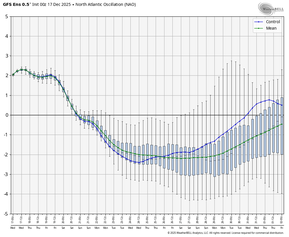
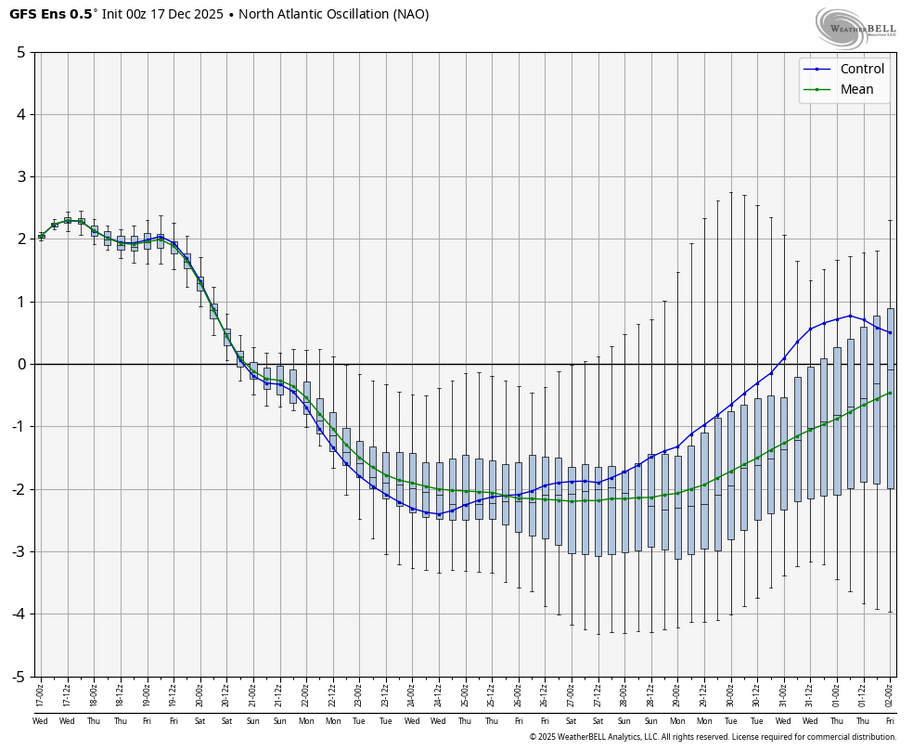
Here’s the 0Z GEFS NAO: week 2 of this and the EPS for the mean (green line) have gotten much more negative just since 24 hours earlier and are now close to the strongest -NAOs of all runs at least since Oct 31st per WxBell’s history that goes back that far: look at green line
-

December 2025 regional war/obs/disco thread
Chrisrotary12 replied to Torch Tiger's topic in New England
Long range Euro just buries Atlantic Canada just bomb after bomb. -
And at some point that moderates and moves; welcome to January’s weather!
-
I'm trying to wrap my head around being at 32 - 34 in Hagerstown while Cumberland & Keyser WV is at almost 60 hahah.
-

Central PA Winter 25/26 Discussion and Obs
pawatch replied to MAG5035's topic in Upstate New York/Pennsylvania
Low was 19 degrees. Currently 29 degrees. I was supposed to smoke some Pork Butts Friday. Looks like that might get put on hold. 40 mph winds is a no go. -
There was definitely a trace of snow that fell in the Hickory/Catawba County area on November 10th, December 8th, and December 12th. There were multiple reports on social media of snow falling on those dates.
-
December 2025 regional war/obs/disco thread
40/70 Benchmark replied to Torch Tiger's topic in New England
They'll end up getting a 4'er in April. -

2025-2026 ENSO
donsutherland1 replied to 40/70 Benchmark's topic in Weather Forecasting and Discussion
New York City's UHI has been around for decades. The numbers are warmer there, but the differences between cooler or warmer outcomes relative to climatology apply. Having said that, there are day-to-day issues at the Park. Actually, Central Park's December lows relative to those at White Plains have changed very little. Of course, when conditions are ripe for radiational cooling, there will be large temperature differences between Central Park and White Plains.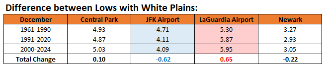
-
What do we consider “flash”? Temps will drop midday on, but I doubt most hit freezing until evening. I’d personally call that regular CAA. It’s not like we’re refreezing slush either.
-

December 2025 regional war/obs/disco thread
SouthCoastMA replied to Torch Tiger's topic in New England
Boulder, more like Smolder -
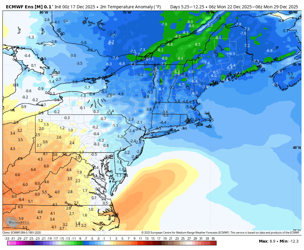
Not backing off much at all really. The difference between a -3 to -4 from 2 to -3 in a long range forecast is pretty much statistical noise. The EPS is around a 0 to +1 the rest of the month. So that would yield a 7 station average of around -3 to -4 from the current -7.7. Long Island is running a little warmer and is only -5.5 at ISP through the 16th.