All Activity
- Past hour
-
 It's that time again ... enter your forecast for seasonal totals of storms, hurricanes, and major hurricanes (in the North Atlantic basin) ... using NOAA official counts as our contest guide. Include any named storms already in the books by 06z June 5th in your total (as of now, count is 0/0/0). 1991-2020 average values 14/7/3 ... 2025 seasonal forecasts from various experts average 17/9/4 (so far). I will include a few of these as of June 1st as non-entries for ranking against our forecasts (without changing our contest ranks). I will probably extend the entry deadline based on the situation as of 06z June 2nd. You can edit or revise any entries up to final deadline, no need to bring attention to edits as I won't be trying to create a table of entries until deadline is passed. Boards.ie weather forum and Net-weather (UK) will be invited to participate. Ranks will be provided (a) over all entries and (b) within forums, or fora if anyone here is a Latin purist. 2024 winner was Kirkcaldy Weather of Net-weather. Good luck !
 -

2025-2026 ENSO
brooklynwx99 replied to 40/70 Benchmark's topic in Weather Forecasting and Discussion
agreed, that was always the main issue with that setup and made it a lot more precarious. if it had a true +PNA, easy KU. one could attribute that to CC, but we were never going to see perfect +PNAs with every setup. I think a lot of it is regression to the mean i agree with you that if this is still happening in a decade, it's time to have a serious convo -

2025-2026 ENSO
40/70 Benchmark replied to 40/70 Benchmark's topic in Weather Forecasting and Discussion
Maybe it edged a bit east, but it never looked great. -
2025-2026 ENSO
brooklynwx99 replied to 40/70 Benchmark's topic in Weather Forecasting and Discussion
yeah, that did not help. what was interesting was I remember the PNA ridge trending "better" as the event moved up, but the ULL deteriorated to the point that it didn't matter. just kinda became messy because of weird ULL stuff. they're finicky, always have been -
Yeah, kinda looks like good bust potential here. If the 12z HRRR comes to fruition, and there is little/no storm action off to the southwest allowing decent venting/tapping warm moist air riding along the tail of trailing convection, there could be a monster sup somewhere in the area. Big IF. But the potential is there.
-
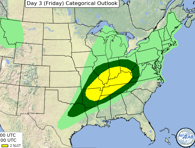
Don't worry @John1122 SPC just has Slight on Friday, and I agree. Of course with high cape and steep mid-level lapse rates, large hail is a concern. However will that type of intense storm be common? There is an argument for bowing segments, which favors straight wind instead. First we should have some thundershowers on Friday morning. Morning rain should leave an outflow boundary in Tenn. It should lift from Tennessee north through Kentucky by Friday afternoon. Thunderstorms should redevelop from Kentucky north into the Lower Ohio River Valley. Kentucky could get a few supercells Friday afternoon. I'd put the hail up there. Indeed CAPE will be high and mid-level lapse rates steep. If one believes the Euro with farther south boundary and rain, it'd be too stable in Tennessee anyway. I figure storms will congeal into a cluster or two in Kentucky, and perhaps come through Tennessee as a line Friday night. That'd favor straight wind over hail. A smaller Enhanced risk would not surprise me around where the Mississippi and Ohio Rivers meet. Depends on if and where a mesoscale triple point can form.
-
it's a late 80s pattern, we saw winters like this in 1988-89 and 1989-90 too. February 1989 and December 1989 being cases in point, historic snowfalls well to our south and along the coastal southeast and midatlantic.
-
2025-2026 ENSO
40/70 Benchmark replied to 40/70 Benchmark's topic in Weather Forecasting and Discussion
I think the system lacking cohesiveness was do at least in part of the crap PNA ridge. I agree with you, though....CC definitely isn't making it any easier, but its not the only reason. -
wow that reminds me of what 2013-14 was here March 2014 was suppressed to the south if it weren't for that, it would have been a snowfall record here, we went from a forecast for 2 feet of snow in the first few days of March to 2 inches in about 48 hours lol.
-
I think the way the NAO is calculated needs to be changed. What is traditionally considered a -NAO doesn't behave like it and isn't really a -NAO. For example we have to divide them into -- west based vs east based vs south based vs north based.
-
2025-2026 ENSO
40/70 Benchmark replied to 40/70 Benchmark's topic in Weather Forecasting and Discussion
March 2015 $hit the bed for my area...everything supressed into the southern half of the region...was cold and dry as the epic pack slowly fossilized and eorded. Cost me a seasonal snowfall record that I was sure I was going to get. -
That must be quite weird to dislike winter but want snow. Most people who dislike winter can just move down somewhere that is milder, but if you like snow you have to be somewhere with winter to get snow. The idea of disliking winter but liking snow is so weird to me. I guess we're all different. As for me, I love winter, snow or not.
-
2025-2026 ENSO
brooklynwx99 replied to 40/70 Benchmark's topic in Weather Forecasting and Discussion
I think part of it is that back in the 2000s and 2010s, most KU setups delivered (March 2018 is a great example), and now we're seeing some flies in the ointment. sure, some of those failure modes are popping up more and more because of CC, but I think we got a bit spoiled, so now a block pops up and everyone expects a KU (I am personally guilty of this and am trying to remove this bias) mid-Feb easily could have occurred, the ULL just became a bit sloppy and the system became more disorganized... it still delivered historic snow to VA beach, and there was also a once in a lifetime Gulf Coast storm -
February 2015 was my absolute favorite winter month on record and it even extended into March!! We had lots of cold, lots of snow and long duration snow cover too!!
-
I hope you realize ( i'm sure you do.. ) that I'm just messin' with you
-
0.65 so far here today after getting 0.36 yesterday. My area had missed out on the heavy rains this month, so this is a much-needed soaking. I'm glad this event is not disappointing.
-
A lot of us were ACATT 15 years ago. Then we got older and wiser.
-
East of the ECD got nailed. Those of us on the west facing slopes (upslope favored areas in winter) fared much, much better. I am at 1.89" for a storm total.
-
garbage weather fan
-
0.37 storm total.
-
Growing up on the Gulf Coast, I noted a few times in my head yesterday that the low clouds and quick movement of the lower layers looked very tropical in nature. Have not been outside today to see if it's the same as yesterday.
-
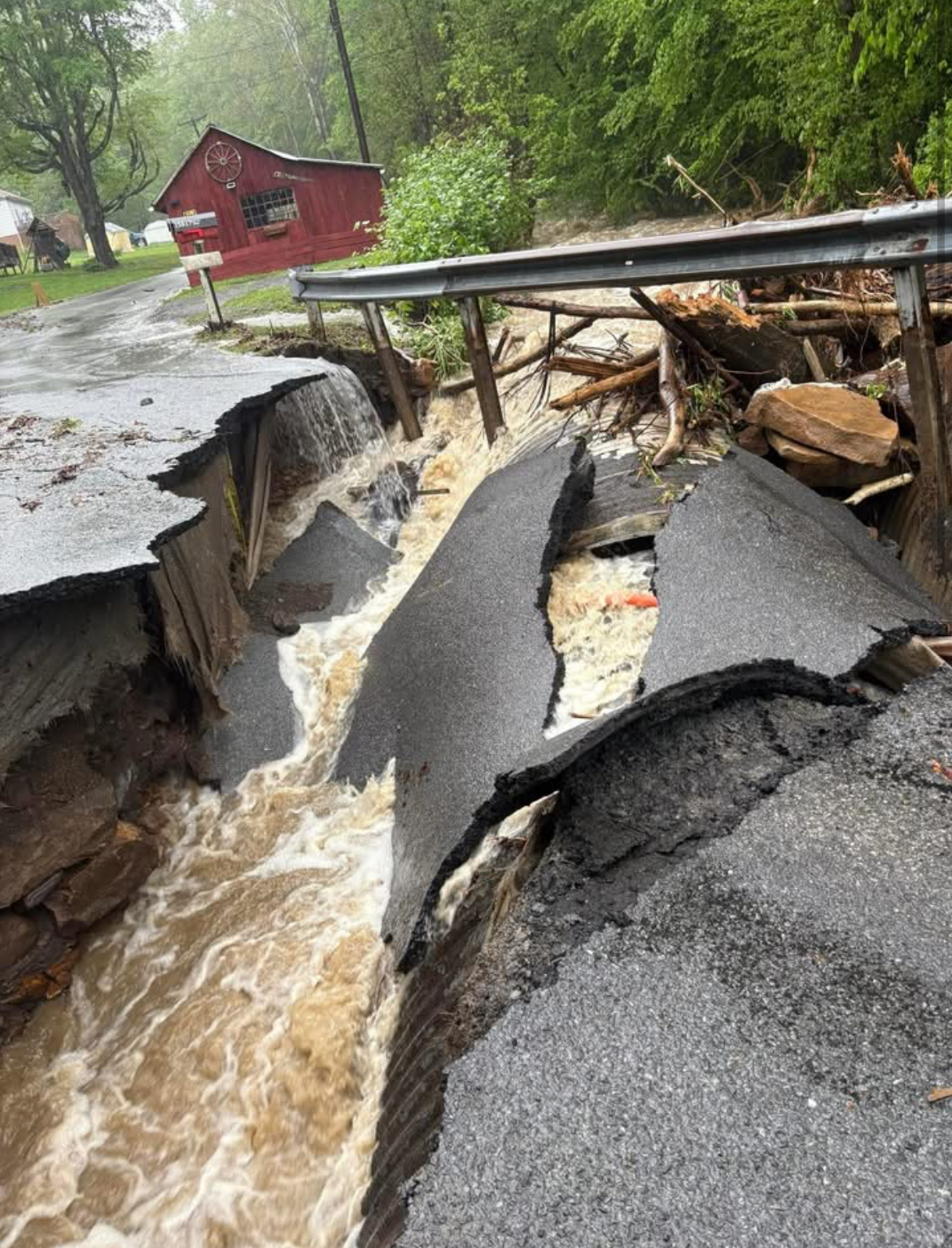
Georges Creek which runs from Savage Mountain south to the Potomac at Westernport took out roads and bridges in towns like Barton and Lonaconing. Folks who live on the hillsides above those bridges are cut off with no way out except on foot. Tough for older folks.

-
We are part of the few people here that absolutely loves winter!!....many people here love snow but they do not love winter..
- Today
-
Looks unsettled through Saturday then hopefully we dry out
-
so much lush green grass everywhere...


.thumb.JPG.418e8a9a2902ae687ec35ff4bc0e038e.JPG)