All Activity
- Past hour
-
AIFS seems off showing too much of a hole in the W Atl ridging N/NW of 98L. The other ML models don't support it's scenario of 98L curving sharply NE toward Hispaniola. https://x.com/yconsor/status/1979887548240650357
-

Spooky Season (October Disco Thread)
SnoSki14 replied to Prismshine Productions's topic in New England
Hard to get cold when the world including North America is on fire. Looks close to normal, which at this point is considered freezing -
WB 11Z HRRR.... has storms crossing the mountains by 11pm.

-
The 0Z UKMET once again has just a rather weak low (not even a TC on the textual output; it has yet to show TCG in the Caribbean on this output though it awhile back had several runs with TCG east of the Lesser Antilles) and again into Nicaragua. The last 5 runs have shown a weak low either hitting Nicaragua (0Z 10/19, 12Z 10/18), barely E of Nic. but heading into it (0Z 10/18, 12Z 10/17), or still 200 miles E of Nic. but likely headed into it). Looking at the H5 vorticity, it appears that as the AOI on the TWO comes into the E Car that a portion of it turns sharply right like the GFS but unlike that model it never develops. Then what looks like a split from this, possibly incorporating additional vorticity coming off northern S America, causes the weak low to move into the SW Caribbean, which is the. goes into Nicaragua. So, the UKMET remains a SW outlier. I should add that yesterday’s 12Z JMA is similar and it has been similar all of the way back to the 12Z 10/15 run. So, the JMA has had 4 12Z runs in a row with just a weak low into Nicaragua or just offshore headed there. Thus both the UKMET and JMA have a good chance to both either fail badly or end up doing the best of the major operationals with this.
-
Of course he blocked you when presented with evidence. These far right cranks are all cowards. When anyone challenges them they either scream "fake news" or ignore you entirely. But hey there's plenty of stupid, ignorant people out there (look at who voted in our current joke administration) that'll continue to follow and support him.
-

Spooky Season (October Disco Thread)
ineedsnow replied to Prismshine Productions's topic in New England
Yup some GEFS members as well.. -
This is clearly a top down warming process. https://www.cpc.ncep.noaa.gov/products/GODAS/ocean_briefing_gif/global_ocean_monitoring_current.pdf
-

Spooky Season (October Disco Thread)
HoarfrostHubb replied to Prismshine Productions's topic in New England
Yellowjackets will be on the move today -

Spooky Season (October Disco Thread)
Damage In Tolland replied to Prismshine Productions's topic in New England
Actually there’s some EPS ensemble member support for the op -
I’ll take 3 of these November, December, January and February.
-
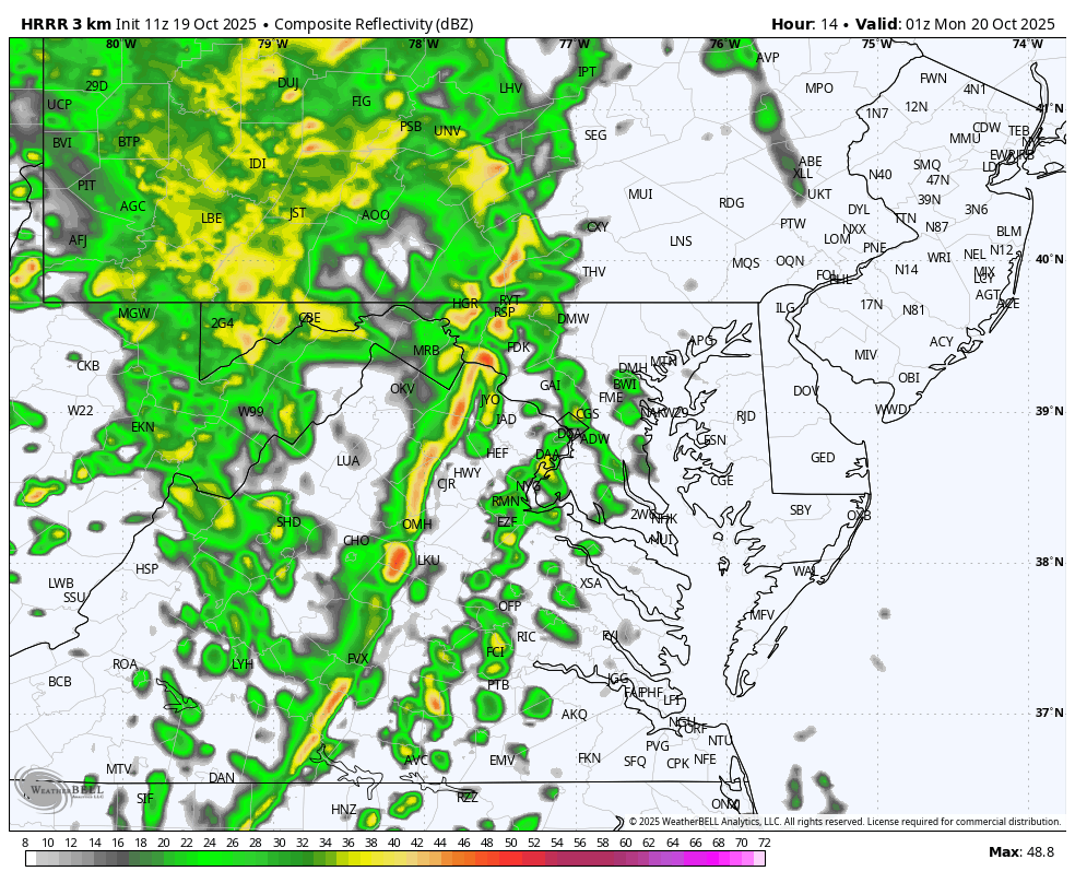
Monday, October 20, 2025 Squall Line Potential
Damage In Tolland replied to weatherwiz's topic in New England
The shortwave trough arrives along with a strong surface front early Monday morning, and moves quickly offshore by mid Monday afternoon. Guidance is in rather good agreement on the timing of the line of heavy rain or Fine Line. The Fine Line should be approaching western MA/CT between 5-7 am and arriving at the I-95 corridor between 8-11 am. The line will then be moving offshore, likely by 1-2 pm in the afternoon. Although Fine Line will be moving rather quickly, it will pack a punch as it moves through and create disruptions to the morning commute. PWATS ahead of the line will be surging to near 1.5 inches, which, combined with the strong forcing from the shortwave, will likely result in rain rates exceeding 1-2 inches per hour. Strong to possibly damaging winds may also accompany the line as low-level winds around 2kft will be approaching 50-60mph. -

Occasional Thoughts on Climate Change
donsutherland1 replied to donsutherland1's topic in Climate Change
After he was corrected on the volcanoes issue with a link to a paper and data source showing warming at the upper and lower levels, he responded by blocking me. The description of the warming as being “top-down,” not “bottom-up,” as would have been the case were volcanoes involved, was too much for him. - Today
-

Spooky Season (October Disco Thread)
CoastalWx replied to Prismshine Productions's topic in New England
Wow just saw it levels Maine lol. What in the actual fuck. -
Spooky Season (October Disco Thread)
CoastalWx replied to Prismshine Productions's topic in New England
Euro is funny. Another cat 1 here. -
Occasional Thoughts on Climate Change
donsutherland1 replied to donsutherland1's topic in Climate Change
At the depths on this chart (< 2000 meters) they are very accurate. At greater depths a different float is used due to the limitations of the standard float. Here’s the description from the standard ARGO float description: The temperatures in the Argo profiles are accurate to ± 0.002°C and pressures are accurate to ± 2.4dbar. https://argo.ucsd.edu/faq/ -
Spooky Season (October Disco Thread)
CoastalWx replied to Prismshine Productions's topic in New England
I see zero signs of any cold to start November. Gonna need a major patter shift. Might come mid to late month. -
Spooky Season (October Disco Thread)
CoastalWx replied to Prismshine Productions's topic in New England
Low 70s today in spots. -
Spooky Season (October Disco Thread)
CoastalWx replied to Prismshine Productions's topic in New England
Holy sell the euro. -
Heavy rain all night here. A real drought buster. Not sure I've seen rain this heavy and sustained in a long time. Of course i'm in Detroit visiting my parents, not back home. I'm sure back in DC it's dry and boring.
-

Spooky Season (October Disco Thread)
Baroclinic Zone replied to Prismshine Productions's topic in New England
No stein here. We wet, lush and beautiful. -
Even warmer than the previous record at this time back in 2022.
-
It’s a new pattern which just developed in the last decade. Record ridging and sunshine over the WPAC leading to these record SSTs. So once Siberia begins getting cold in the fall a strong temperature gradient develops driving the much faster Pacific Jet. https://www.cpc.ncep.noaa.gov/products/GODAS/ocean_briefing_gif/global_ocean_monitoring_current.pdf
-
Spooky Season (October Disco Thread)
HoarfrostHubb replied to Prismshine Productions's topic in New England
Stein will save us -

2025-2026 ENSO
Stormchaserchuck1 replied to 40/70 Benchmark's topic in Weather Forecasting and Discussion
I was surprised NOAA had 19 Named Storms at the high end of their range this season.. their high end was 25 Named Storms last season.. they have been too high 2 years in a row. Global ACE hasn't been as the same as Atlantic ACE and I think that is going to level out a bit in the coming years. As for the MJO, long range models have been trying with the idea of a +PNA last few days of October, into the first week of November. It will be interesting to see how that verifies.. I think there is some expectation of the MJO making it to Phase 7. -
Yeah I think so. March was the snowiest month of the season.