All Activity
- Past hour
-
.23 so far for today and .74 for the event here. Not as much as you guys, but still beneficial.
-
I hit 100.9 at home at 2:24PM today and then 101.1 at 2:35PM, which are the hottest I’ve seen on my thermometer so far this summer! The good news though is that I’ve already heard thunder and prospects for a much cooler late afternoon than the prior 3 days are very high due to outflow boundaries from nearby thunderstorms at the least, and probably also actual rainfall. It has already dropped to back quite a bit with 96.9 now due to increased clouds and popups nearby.
-

2026-2027 Super El Nino
TheClimateChanger replied to Stormchaserchuck1's topic in Weather Forecasting and Discussion
I made this nifty graph to track the ongoing push for what could become the hottest month on record for the contiguous United States. Through July 10, PRISM had the national temperature anomaly at roughly +2.12°F relative to 1991–2020. Based on observed temperatures and the current NBM forecast, my provisional estimate rises to around +2.60°F through July 21. Obviously, that figure remains subject to change as observations come in and forecasts evolve. The historical significance would be difficult to overstate. July 1936 still holds the national record at +2.38°F and represents the oldest surviving warm-month temperature record in U.S. weather history. July 2012 came extraordinarily close at +2.34°F, but fell just short. So this is not merely a run at another monthly record. It is a serious challenge to one of the most famous and durable benchmarks in the American climate record—one that has stood for 90 years. -

2026-2027 Super El Nino
jaxjagman replied to Stormchaserchuck1's topic in Weather Forecasting and Discussion
We had a -PDO in the strong NINO of 57-58,we just had some good North Atlantic blocking,it was quite cold in the TnValley,maybe Global warming is a player now which seems possible,but that was quite unusual when you see waterways in Mid Tn freeze up in J/F,it that happens agin who knows -

Spring 2026 Pattern Discussion Thread
Carvers Gap replied to Carvers Gap's topic in Tennessee Valley
Kind of rainy, cool, very humid day here at TRI. We used to get these a lot. Nice to see them every once in a while. Heavy rains have fallen in the foothills near Greeneville as others have noted. -

2026-2027 Super El Nino
GaWx replied to Stormchaserchuck1's topic in Weather Forecasting and Discussion
Per NOAA in DJF (my def. of neutral PNA is between -0.25 and +0.25) 1. 2024-5 was, indeed, very +PNA with a whopping 72 of 90 days being +PNA vs 18 neutral PNA and zero -PNA! That’s amazing for La Niña! Going back to 1949-50, the only other DJF without a single -PNA day was 2002-3! 2. 2025-6 was actually a more typical La Niña with more -PNA than +PNA: 49 -PNA, 14 neutral PNA, and 27 +PNA. https://ftp.cpc.ncep.noaa.gov/cwlinks/norm.daily.pna.index.b500101.current.ascii -
Day 4 NSSL machine learning likes a day 4 threat and days 9, 10 and 11 as an active period. https://x.com/TylerSebreezy/status/2076303103263932677 The latest NSSL machine-learning severe probabilities highlight a potential northwest flow setup for a handful of days across the eastern U.S. The risk of some strong to severe storms appears evident at times.
-
Max heat begins to move West later this week.
-

2026-2027 Super El Nino
LakePaste25 replied to Stormchaserchuck1's topic in Weather Forecasting and Discussion
We will see. I don’t deny that there could be *some* destructive interference. I’m just arguing that the event will be so strong and well-coupled that it won’t have a significant outcome that diverges from the canonical El Niño winter pattern (GOA low, strong southern stream, above normal N Tier, and wet S tier). 97-98 likely had constructive interference. -
I’d rather have the January 2008 60s with severe weather.
-
Yeah we've had a lot of rain since Saturday morning. Over 2 inches here probably close to 3 inches now and up. Been a lot of water falling. Definitely putting a dent into the drought.
- Today
-

2026-2027 Super El Nino
roardog replied to Stormchaserchuck1's topic in Weather Forecasting and Discussion
You could say that this year is its own oddball so far. A record El Niño for this time of year with a still strongly -PDO with a -PDO type of North American pattern. It just makes me leery that we’re suddenly going to see a flip to 1997 across North America. No doubt much of the rest of the globe is and will continue to look very Ninoish. -
2026-2027 Super El Nino
LakePaste25 replied to Stormchaserchuck1's topic in Weather Forecasting and Discussion
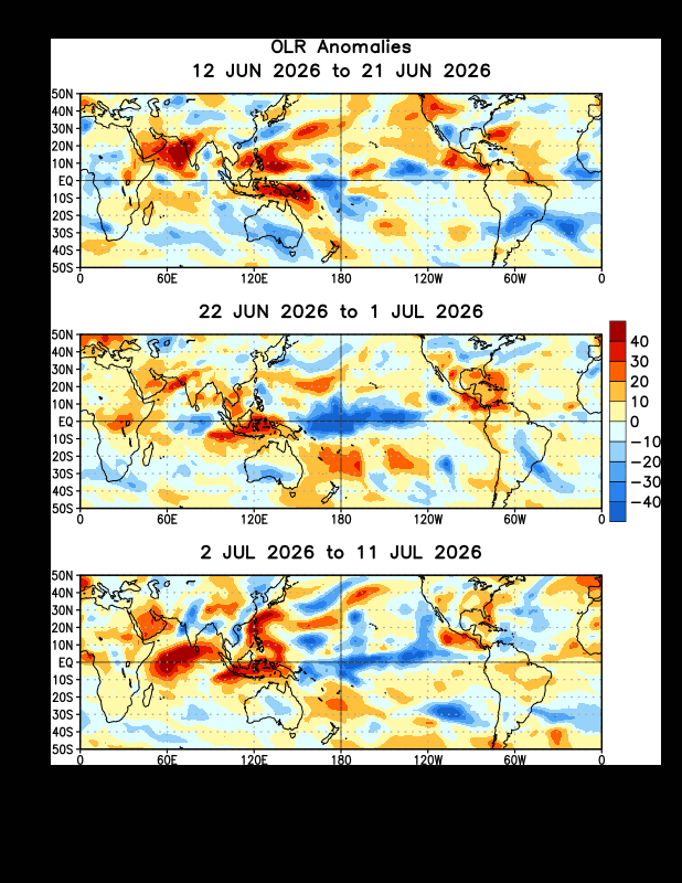
OLR is exactly what you’d expect in July for an E based Nino. Note the convection going north as you go east…that’s consistent with climatology this time of year due to the Humboldt current which impacts Nino 1+2.
-
Think we manage an mcs into the area at some point but I get the sentiment here
-
2026-2027 Super El Nino
LakePaste25 replied to Stormchaserchuck1's topic in Weather Forecasting and Discussion
15-16 was an oddball. Unusually strong MC forcing in december and in Jan/Feb the E Pac convection was unusually far north (failed to collapse near the equator as it’s supposed to do during winter), which actually enhanced Baja ridging as it was the descending branch of the Hadley Cell. Both of these factors helped contribute to the record warm December and the Mid Atlantic blizzard. -
 This is the year. When few are expecting it with a super Nino ( except me who thinks it the year)
 -
2026-2027 Super El Nino
jaxjagman replied to Stormchaserchuck1's topic in Weather Forecasting and Discussion
Actually if you go back to 57-58 it was quite cold after Dec,while NOV like you mentioned was BN,Dec was more severe,but J/F was really cold,if that happens again who know,plus March of 1958 had the blizzard in the east -
2026-2027 Super El Nino
roardog replied to Stormchaserchuck1's topic in Weather Forecasting and Discussion
You would think so but even 2015-2016 seemed to have some outside influence and that was a beast of an El Niño with a strong +PDO. We can’t even sniff a +PDO this year so far and it seems the North American pattern is making sure we know that. -

2026 Spring/Summer Mountain Thread
Maggie Valley Steve replied to Buckethead's topic in Southeastern States
I'm getting a little concerned with the repeated rounds of heavy rain. The WPC has concerns also.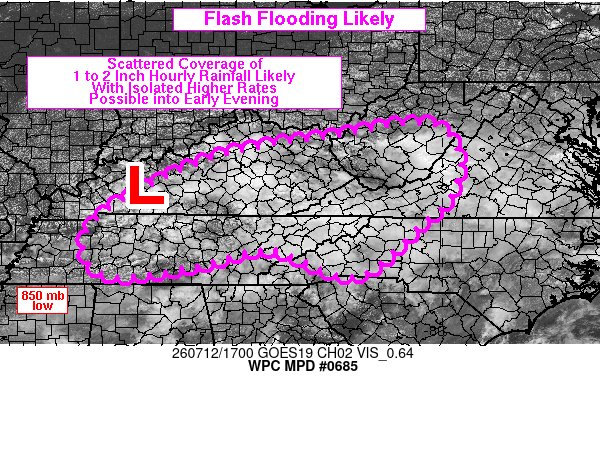
-
 You need something to pop off the SE coast from a stalled front.
 -
2026-2027 Super El Nino
roardog replied to Stormchaserchuck1's topic in Weather Forecasting and Discussion
That’s the funny thing about 1997-1998. I recall there being more cold early in the winter than later in the winter which is kind of opposite what you think of with El Niño. Of course November was quite cold so there was probably quite a bit of lake effect that month. One memory for me that stands out from that winter was being on the SW edge of the Arctic airmass that eventually went on to produce the catastrophic Canadian ice storm. We started out with freezing rain but changed to rain before it got too bad. -
57-58 was quite unique.Nashville recorded the 6th lowest BP reading on record in Feb.Also into April had its 2nd strongest wind readings.There was the big blizzard in March in the east that dumped 2-3 feet along Conte.But it was so cold here that winter JAN/FEB it froze the waterways in MID TN.Plus we had the typical severe outbreak in Dec 57,with strong NINOS
-
2026-2027 Super El Nino
LakePaste25 replied to Stormchaserchuck1's topic in Weather Forecasting and Discussion
My opinion is that it’s such a strong looking event that you leave less room for things such as the PDO to influence the pattern, especially when it can potentially flip. It’s still early in its development. Previous winters the ENSO state was fairly weak so there were more opportunities for competing influences to destructively or constructively interfere. -
Let’s get that cane there into the Bahamas
-
Today it will be 21-24 degrees celsius at 700mb over part of Colorado,. The highest temperature than Grand Junction, weather balloon sounding archive, has ever measured, is 22C