All Activity
- Past hour
-
 I’m modestly intrigued.
 -

November 2025 general discussions and probable topic derailings ...
dryslot replied to Typhoon Tip's topic in New England
Just the tip huh? -

December 2025 Short/Medium Range Forecast Thread
Carvers Gap replied to John1122's topic in Tennessee Valley
The 6z Euro AIFS has some company. -
December 2025 Short/Medium Range Forecast Thread
Carvers Gap replied to John1122's topic in Tennessee Valley
Well, well, well...look what the 12z GFS just drug in. -
I don’t post here often, but happened to stumble upon this just now. Agree with what you said—it has been cloudy and windy (and snowy) with the coldest air masses—not great for rad cooling. I also agree with Bluewave on how warm Canada has been generally in recent years. If you look at most recent Decembers, with the exception of last year they have been headed in a warmer direction. The locals here talk about how fast a start it has been with snow, but we haven’t had any truly cold nights relative to what the area can get (not that I’m a local, I’m new to the area). It’s been a cold month overall however. The airport is -3.3° as of 11/17. Normal hi/lo for today is 41/21. In the village we had a low today of 24…but we’re currently at 27° and will struggle to hit freezing again.
-
November 2025 general discussions and probable topic derailings ...
dryslot replied to Typhoon Tip's topic in New England
Don't bank on it, After the last few winters. -
 12z gfs and 6z euro were well north from earlier runs
 -

November 2025 general discussions and probable topic derailings ...
MJO812 replied to Typhoon Tip's topic in New England
Gfs unloading the Arctic next week -
I forget when Jeff moved to Florida but when he was still on WCBS here he would occasionally post on here, or maybe it was on Eastern before this one.
-

November 2025 general discussions and probable topic derailings ...
weathafella replied to Typhoon Tip's topic in New England
Well we’ll be in Chicago for thanksgiving planning to head home beginning 12/3. That area looks decent for some early action just past thanksgiving. -
Looks like a perfect vort pass for the system tonight. Too bad it’s not colder…could have been an easy advisory level event.
-
Overnight Euro ENS continue to cool for December.
-
Just looked. I guess he missed his post yesterday about the mini heat wave about to hit the southern portion of the country.
-
Low of 30, first freeze imby and a frosty morning.
-
it did. it's only clouded up in the last 30 minutes.
-
Jeff Berardelli is who he meant. E.g., https://www.facebook.com/JeffBerardelli/
-
Who?
-
I trust metsfan with crayons and a map of australia more than i trust the hrrr if it shows me getting snow
-
 Well here's the thing... Globals overall have not held onto the structure of the oncoming short wave into confluence zone in NYS New England so have been depressed. 6z EC topped in favor of the 06-09z RRSFA, RAP, NAM3K and 12z HRRR. I sure hope the 12z/18 HRRR is not that far wrong... it could be too aggressive to the north but I expect a 2-4" stripe somewhere near I80 which would be a little south of the 12z HRRR axis. Uncertainty of course but we have to make decisions on what we do. So potentially embarrassing if it fails but this is what I updated locally. Updating I84 corridor 9AM. Plowing will probably be needed for at least the higher elevations tomorrow morning from northeast PA through nw NJ/se NYS into at least southern CT and possibly Hartford Ashford. Too much short term modeling that is at the leading edge of mesoscale modeling is upping amounts and predicting a decent 5 hour event that will require adjusted traveling times. Entire I84 region from the Poconos across nw NJ, se NYS into ag least the southern two thirds of CT 1AM-9AM Wednesday (tomorrow) morning. A 3-6 hour period of wet snow that likely accumulates 1-4"-especially grass. Valley roads 600 feet or below just wet because of temps just above freezing but accumulations on untreated pavements expected for the hills where the temp will drop to 30, especially 1000 feet or higher. The northern extent of the snow shield is a little uncertain but prepare for slower travel-delays in your early Wednesday morning travel. In my opinion there is an increasing chance of a 2 hour delay for high terrain schools I80 northward. Overall
 -

November 2025 general discussions and probable topic derailings ...
CoastalWx replied to Typhoon Tip's topic in New England
I don’t expect it but if the above happens as you said I’m out until the first 70F dews. -
Insane
-
I think it’s because last year was horrific, and once Dec 1 hits the clock starts ticking in every weenie’s head. If we get to Dec 15 and this pattern is delayed another two weeks with a Grinch in sight, this place will be hell. (I don’t think that’ll happen, but just saying) I just looked. It’s on something, but we’d certainly take lol.
-
December 2025 Short/Medium Range Forecast Thread
Carvers Gap replied to John1122's topic in Tennessee Valley
6z Euro AIFS FTW....been wanting to post that all morning. Cloudfare had other plans. Thankfully, systems are slowly coming back online. -
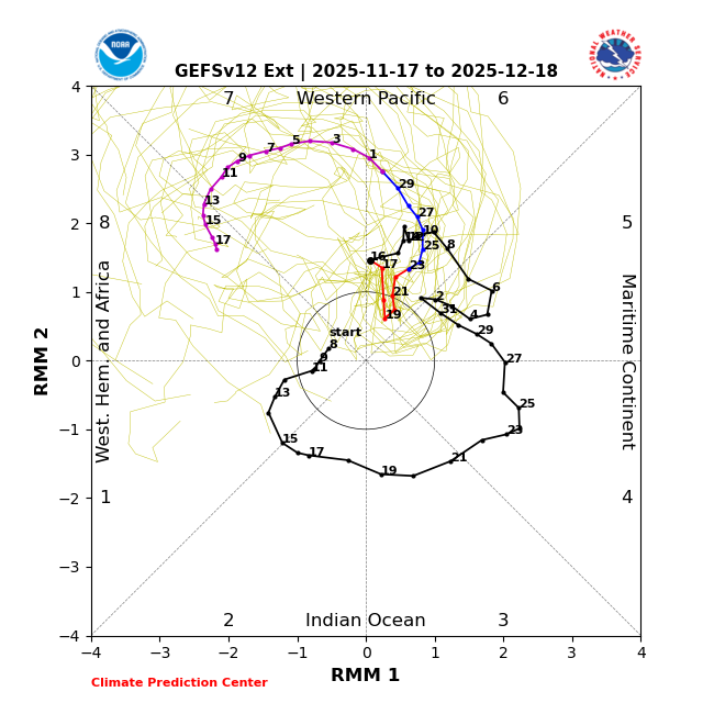
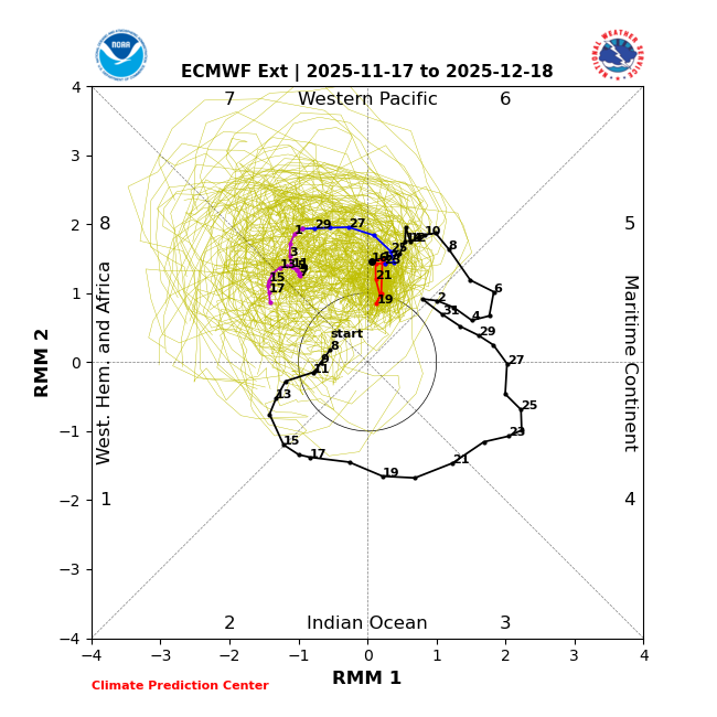
MJO model progs: -11/18 GEFS/EPS runs similar to yesterday day by day along with good progression into 7(GEFS) and well into 7 (EPS). -11/17 extended EPS remains consistent with recent runs with it getting into 8 on 12/14. But the big news is that the extended GEFS is its most progressive yet and with it actually moving into 8 a day earlier than the EPS (12/13). At RDU/BWI since 1974 for the 23 three+ day long Dec phase 8 periods averaged out: lots of variation but with solid tendencies -78%/61% of Dec phase 8 were cold -Compare that to only 22%/13% that were mild -Phase 8’s three+ day long periods have averaged 5 days with the longest being 13 days -Phases 1 and 2 have also averaged cold at BWI but with again lots of variation but with solid tendencies Based on all of this as well as a typical couple of weeks+ lag of cold in the E US after an SSWE, I’m hoping for E US cold domination to start around Dec 15th. Until then, I expect mild to dominate much of the E US, especially mid-Atlantic south. 11/17 GEFS extended: 11/17 EPS extended: