All Activity
- Past hour
-

2025-2026 ENSO
40/70 Benchmark replied to 40/70 Benchmark's topic in Weather Forecasting and Discussion
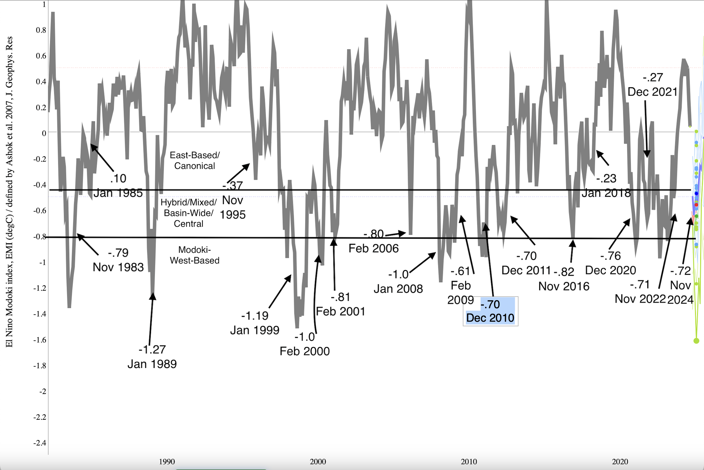
@snowman19 The fact that region 1.2 is so small skews the EMI away from heavily east based events....if you look at this graphic I made of EMI rankings since 1980, the only event in positive territory is 1985, but weakly positive (east-based) events are still considered east-based. The Jamstec ensemble mean forecast is most similar to 1995, 2017 and 2021.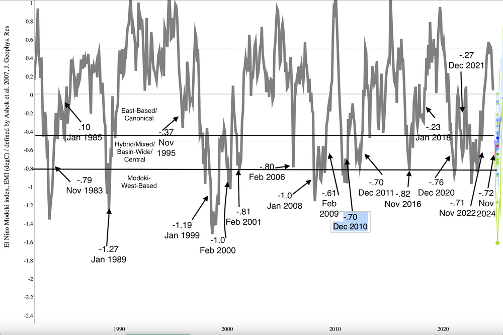
-

July 2025 Discussion-OBS - seasonable summer variability
IrishRob17 replied to wdrag's topic in New York City Metro
“Delightful” strong odor of wildfire out there today. -
Yes indeed, relief is on the way again! We had a nice couple of days earlier this week as well. As long as we get breaks every other week, I can cope with Summer heat.
-

2025-2026 ENSO
PhiEaglesfan712 replied to 40/70 Benchmark's topic in Weather Forecasting and Discussion
Summers at PHL since 2010: Colder than the 1981-2010 average: 2014, 2023 (although this one ends above average if we use JAS instead of JJA) Warmer than the 1981-2010 average, but colder than the 1991-2020 average: 2013, 2017 Warmer than the 1991-2020 average: all other years (2010-2012, 2015, 2016, 2018-2022, 2024) Looking ahead, it looks like 2018 (which is only 0.2 degrees above the 1991-2020 average) will fall below the 2001-2030 average. Along with years like 2001, 2006, and 2008, which were at the time Top 10 warmest summers on record. -

July 2025 Obs/Disco ... possible historic month for heat
weatherwiz replied to Typhoon Tip's topic in New England
Definitely Smokey out there and at ground level. Clear smell of smoke -
2025-2026 ENSO
40/70 Benchmark replied to 40/70 Benchmark's topic in Weather Forecasting and Discussion
It certainly doesn't argue for a Modoki. I agree that it isn't east-based in the sense that it matches up with the most extreme members of that grouping, but region 1.2 is so small that it doesn't weight the index much. When considering the subsurface cold pool is not below region 4 and is under region 3, the EMI would be biased slightly east, as the JAMSTEC data forecasts. I do agree that it isn't a huge deal since it will be so weak.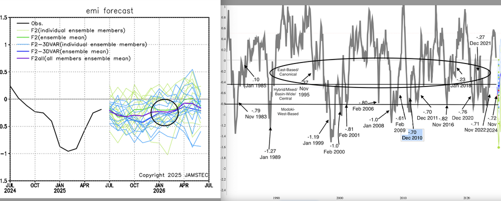
-
 Below is an analysis of excessive heat - represented by temperatures exceeding 100 degrees in Chester County PA by decade from the 1890's through today. There is a clear trend for less excessive heat days with 100-degree readings becoming a relatively rare event compared to the 1900's through the 1950's. On average Chester County PA is down to maybe 1 time per station per decade. The below shows the number of days, average days per station - this is included to take into account many less stations prior to the 1990's. Of interest is even though there are more current stations at similar elevations relatively close to those older historic stations excessive heat is just not like it was for our parents and grandparents.
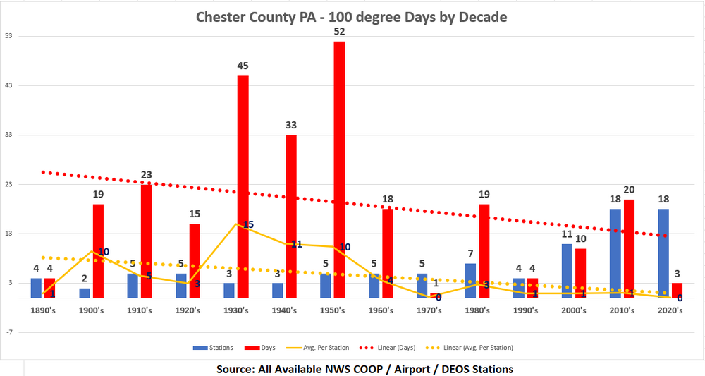
-
After reading this from the GSP NWS, I am looking forward to next weekend. .LONG TERM /TUESDAY THROUGH FRIDAY/... As of 139 AM EDT Friday: Deep upper ridging will continue through the middle of the week, and as a result widespread heat issues will continue at least through Wednesday. Meanwhile, a robust 500mb low will develop over eastern Canada, gaining momentum and pivoting into Quebec on Thursday...and resulting in markedly lowered heights over the Southeastern U.S. This should, at long last, bring an end to the heat wave. Models begin to diverge toward the end of the period, but the general consensus is that sometime on Friday into next weekend, a cold front will dig out of the Ohio Valley into the Carolinas, spurring an increase in shower/thunderstorm activity while ushering a cooler, drier air mass into the region. Despite ensemble variability by this point, confidence is improving in low severe potential with this system...as even the more aggressive end of the ensemble envelop keeps deep shear too low for anything more than loose organization, and a distinct lack of dry air aloft should keep DCAPE limited.
-
Below is an analysis of excessive heat - represented by temperatures exceeding 100 degrees in Chester County PA by decade from the 1890's through today. There is a clear trend for less excessive heat days with 100-degree readings becoming a relatively rare event compared to the 1900's through the 1950's. On average Chester County PA is down to maybe 1 time per station per decade. The below shows the number of days, average days per station - this is included to take into account many less stations prior to the 1990's. Of interest is even though there are more current stations at similar elevations relatively close to those older historic stations excessive heat is just not like it was for our parents and grandparents.
-
E PA/NJ/DE Summer 2025 Obs/Discussion
ChescoWx replied to Hurricane Agnes's topic in Philadelphia Region
Below is an analysis of excessive heat - represented by temperatures exceeding 100 degrees in Chester County PA by decade from the 1890's through today. There is a clear trend for less excessive heat days with 100-degree readings becoming a relatively rare event compared to the 1900's through the 1950's. On average Chester County PA is down to maybe 1 time per station per decade. The below shows the number of days, average days per station - this is included to take into account many less stations prior to the 1990's. Of interest is even though there are more current stations at similar elevations relatively close to those older historic stations excessive heat is just not like it was for our parents and grandparents.
-
2025-2026 ENSO
40/70 Benchmark replied to 40/70 Benchmark's topic in Weather Forecasting and Discussion
Completely agree with your bolded take. -
I don't think that means they've given up on Adley yet. (And the 1st pick is likely to become an OF, imo). Now I'm thinking they eventually alternate Basallo and Adley at DH...
-
I'll take a more positive look - next week looks amazing. Last few days of the week look sunny with highs in the upper 70s and very low dewpoints.
-
2025-2026 ENSO
40/70 Benchmark replied to 40/70 Benchmark's topic in Weather Forecasting and Discussion
But he loves to call out the speculative posts of others from months earlier that didn't turn out to be correct...not to mention routinely make baseless claims of plagarism. Yea, he wasn't argumentative at all. I get @so_whats_happening's frustration with the bickering, but the his raindance reference was one of the least insightful posts in the entire thread given he was one of the more incendiary posters. I agree regarding the quality of his analysis for the most part. -
Not much out there. Summertime doldrums.
-

July 2025 Obs/Disco ... possible historic month for heat
WxWatcher007 replied to Typhoon Tip's topic in New England
Smoky but nothing crazy -
What I have is a bit of a rain shadow from higher elevations from W around to NE of me. T-storms will break up dropping down, then reorganize just east. Stephens City is a much worse example of this. OT but I just checked the weather in Morehead City/Atlantic Beach area where our two kids went and they have an extreme heat warning for heat index of up to 115! Oooooof
-
.12” rain yesterday. 73 was the low, 96 the high. Next week looks brutal. Mid to upper 90s Monday through Wednesday.
-
.thumb.png.4150b06c63a21f61052e47a612bf1818.png)
July 2025 Obs/Disco ... possible historic month for heat
HIPPYVALLEY replied to Typhoon Tip's topic in New England
My eyes were burning, walking the dog this morning. - Today
-
July 2025 Obs/Disco ... possible historic month for heat
HIPPYVALLEY replied to Typhoon Tip's topic in New England
I just got two cords delivered yesterday. -
.17" of rain yesterday from the evening storm.
-

July 2025 Obs/Disco ... possible historic month for heat
rimetree replied to Typhoon Tip's topic in New England
Breathe it in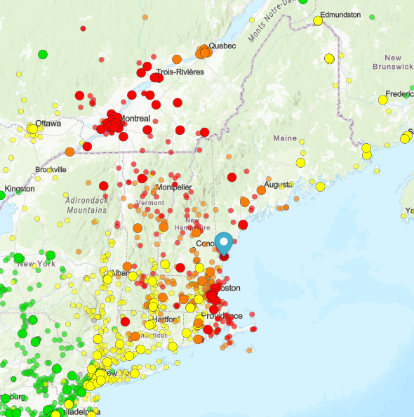
-
 August DCA _ NYC _ BOS ___ ORD _ ATL _ IAH ___ DEN _ PHX _ SEA 1.0 1.0 0.5 1.0 1.5 2.0 0.5 1.5 0.5
 -
July 2025 Obs/Disco ... possible historic month for heat
rimetree replied to Typhoon Tip's topic in New England
81/58...pretty much ideal. Hoping we can translate this to first week in Aug when down on the Cape. A little humidity won't hurt but don't want everything covered in dew. Doesn't look wet at this range so fingers crossed. -
My entire childhood it seemed every storm went north of me and hit Glen Burnie. They still do. That place is a magnet for storms. I'd be interested to see a map of thunderstorm frequency over the past 100 years. It would be interesting to see if some areas do better then others. Besides the obvious areas like Stephen City lol