All Activity
- Past hour
-
Truly excellent work. Thank you!
-

November 2025 general discussions and probable topic derailings ...
das replied to Typhoon Tip's topic in New England
The lowest low here in Charlotte has been 21.2°F. If we hit 50°F on Wednesday (increasingly unlikely), it’ll be the first >50’s since the 8th. Days and days of 30’s and 40’s for highs. Chilly but not cold. -
Yeah unfortunately the RNA creates a SE ridge, and without blocking can facilitate cutters. This really feels like the old fashioned warm wet, cold dry years of the past. Last year we had plenty of cold but remained dry.
-
(002).thumb.png.6e3d9d46bca5fe41aab7a74871dd8af8.png)
Central PA Fall Discussions and Obs
ChescoWx replied to ChescoWx's topic in Upstate New York/Pennsylvania
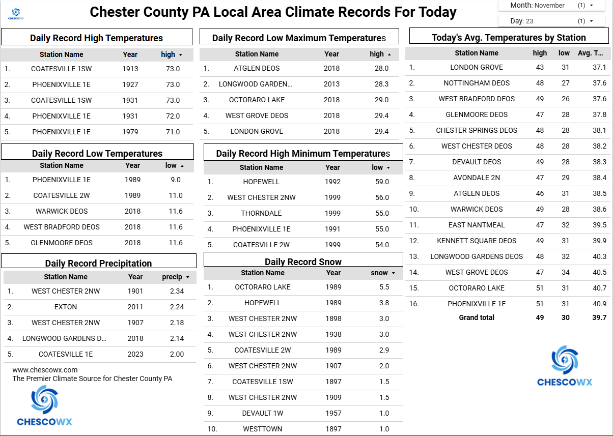
After a frosty start in spots, we should see sunny skies with temperatures not too far from normal for both today and tomorrow. Rain chances increase by Tuesday afternoon with some spots seeing the potential for up to 0.50" of rain before it ends on Tuesday night. Wednesday looks like our one warmer day before we turn back to well below normal temperatures for the Thanksgiving Holiday and weekend.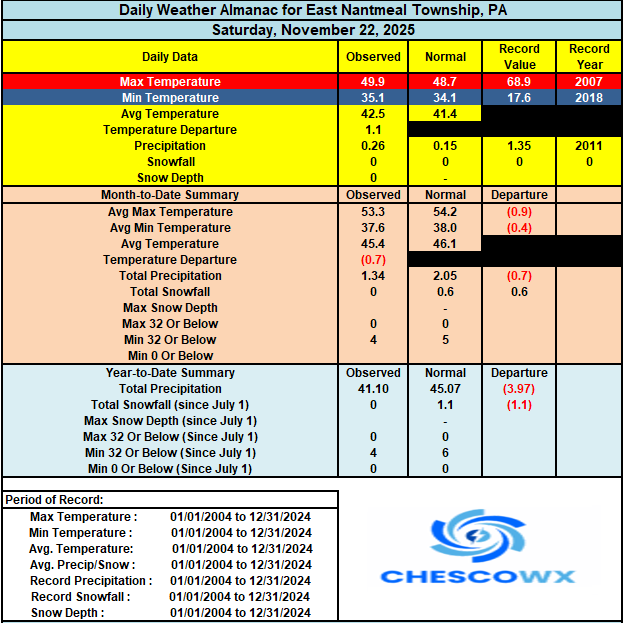

-
E PA/NJ/DE Autumn 2025 Obs/Discussion
ChescoWx replied to PhiEaglesfan712's topic in Philadelphia Region
After a frosty start in spots, we should see sunny skies with temperatures not too far from normal for both today and tomorrow. Rain chances increase by Tuesday afternoon with some spots seeing the potential for up to 0.50" of rain before it ends on Tuesday night. Wednesday looks like our one warmer day before we turn back to well below normal temperatures for the Thanksgiving Holiday and weekend.
-
I mean if all it takes is a cold Siberia and warm Pacific to end winter then we are never going to get cold and snow ever again
-
Sunday low imby/Columbia a toasty 34°.
-
 Well there, you have it. Winter's canceled. Nothing good is going to happen. On to next winter. I guess we'll see you on here then.
 -
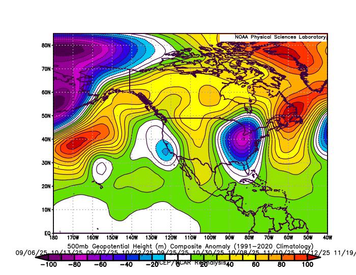
During more +PNA intervals like this fall the, the Southeast ridge was focused to the east building into Eastern New England and Canada on our 10 wettest storm days. So these frequent WAR and Southeast ridge patterns are interchangeable. They both have been leading to dominant Great Lakes cutter and hugger storm tracks whether we have had +PNA or -PNA patterns over the last 7 years since 2018-2019. 10 wettest days storm track 500 mb composite this fall around the area with dominant Great Lakes cutter and hugger storm tracks and strong +PNA WAR pattern
-
Like I said, hes pushing 50 and banned from multiple boards for years for being an idiot. Some people dont grow up. 25 this morning, coldest of season so far
-

November 2025 general discussions and probable topic derailings ...
WinterWolf replied to Typhoon Tip's topic in New England
But It’s also been consistent…that was my point. Doesn’t mean anything with regard to the upcoming winter season, just like only a couple coastals means nothing either..only that it has been consistently cool/cold for autumn and November. -
Let's see how the AI model performs in December -will it show some consistency moving forward ?
-
 Watching this right now…
 -
I'm never cooked, only relaying information. My realistic views usually serve me well!
-
The dry part is more concerning than the warm part IMO
-
November 2025 general discussions and probable topic derailings ...
WinterWolf replied to Typhoon Tip's topic in New England
Agreed. It’s a different year, we’ll have our chances. -
Maybe no one on here but plenty of people have. Also , no clue why are you throwing in the towel in November. You do this all the time.
-
Literally no one is predicting December to be cold and active
-
27 here earlier this morning, frosty
-

November 2025 general discussions and probable topic derailings ...
Kitz Craver replied to Typhoon Tip's topic in New England
Nice little scooter high nudging in for the SWFE at the end of the EURO run. It’d be refreshing to see HP timing and placement coalesce with approaching shortwaves for maximum potential rather than decaying HP’s exiting stage right every damn time. -
November 2025 general discussions and probable topic derailings ...
WinterWolf replied to Typhoon Tip's topic in New England
It means nothing either in the grand scheme of things. -
Thanks, one more thing i wanted to mention. The radar from 2003-present is from IEM (Iowa State) where you can create and save to a gif but 2002 and earlier is from NCEI interactive radar that cannot be saved and you can only view one still snapshot in time. So to make those i had to capture images, frame by frame import them into photoshop, crop and sort them and make an animated gif or .mp4 video file from those frames, which was the most tedious thing you can imagine....each storm is 100-200 frames (Mar 4-6 2001 is 400 frames). But i think it's really cool to see the radar of these old storms, that were once lost to time, in an animation.
-
Unreliable D10-11 EPS signal, but cyclically advertised, possibly biased high by single model output... an ice event I84 corridor around Dec 3-4? Standard high terrain but even some minor indication valleys just nw of I95. Again D10-11 so chances are? I am monitoring for myself.
-
Saw the prior 24 hours of posts... and suggests but not locked into a Wind Advy thread Fri 11/28, possibly starting Thanksgiving afternoon. Awaiting 12z/24 (Monday) modeling.