All Activity
- Past hour
-
would this be considered a SWFE or a Miller A Nor'easter?
-
CMC going to be good
-
yep, think it's gonna be icy. CMC and it's para were icy last night so it's at least consistent. Canadian models love ice and I swear they are always too cold
-

Nov 28-30th Post Turkey Day Wintry Potential
michsnowfreak replied to Chicago Storm's topic in Lakes/Ohio Valley
Chicago saw under 20 last winter. I dont mind that they'll get more than us this storm. Regardless looks like a widespread advisory to warning criteria snowstorm. Thats on top of the early November 9-10 snowfall and cold as far as the eye can see...excellent start to winter! -

Nov 28-30th Post Turkey Day Wintry Potential
Chambana replied to Chicago Storm's topic in Lakes/Ohio Valley
4.6” final call. Chicagoland looks locked and loaded for a solid 6-9” event -
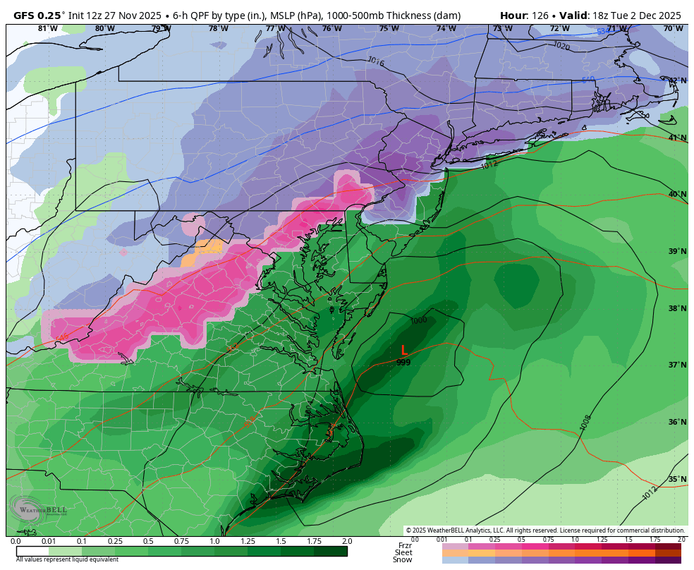
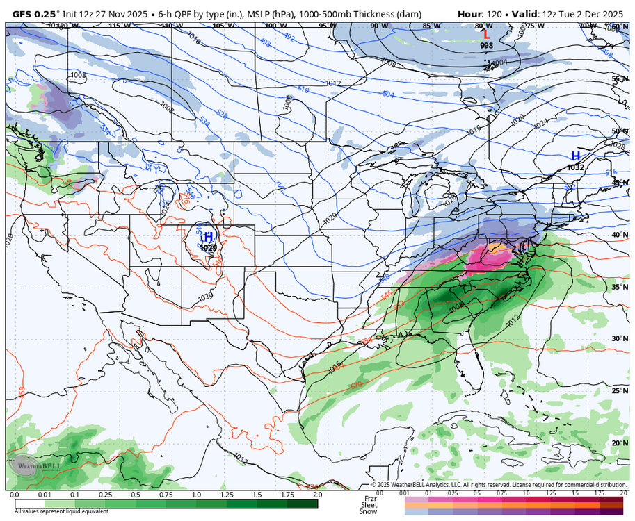
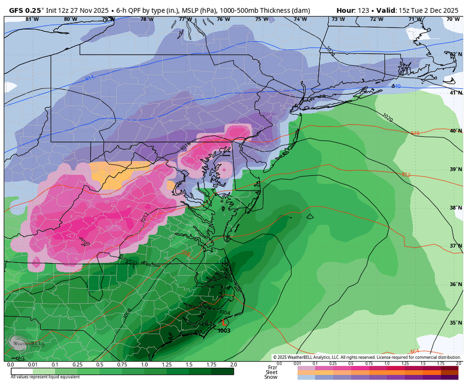
We lost the 850s before the storm started so will be icy instead of snowy.
-
Don't have the pretty maps but don't see how Canadian doesn't start us wintry, whether snow or ice. Pretty darn cold right before the precip rolls in
-
Unfortunately the classic SWFE has become somewhat of a lost thing in recent years much like the clipper and coastal track have seemed to. I think it’s a product of stale highs due to warming in Canada coupled with systems having a tendency to want to overamp more in that setup vs just remain weak flat waves bumping into highs, I can’t remember the last case of that we had. We have seen more SWFEs have long duration periods of sleet which 20-30 years ago almost never happened. They were usually snow to rain 9 out of 10 times
-
Still feel fall line s and e will have to wait for theirs. One gfs run doesn't change my thoughts.
-
Nov 28-30th Post Turkey Day Wintry Potential
michsnowfreak replied to Chicago Storm's topic in Lakes/Ohio Valley
3-6" seems like a good call for Detroit. -
Well, if anybody would know...
-

Central PA Fall Discussions and Obs
Superstorm replied to ChescoWx's topic in Upstate New York/Pennsylvania
Getting better . -
thats even better ! Walt is going to have his work cut out for him trying to figure out how to explain all of this in the storm thread......
-
hasnt things trended colder on the whole? or is that weenie wishcasting
-
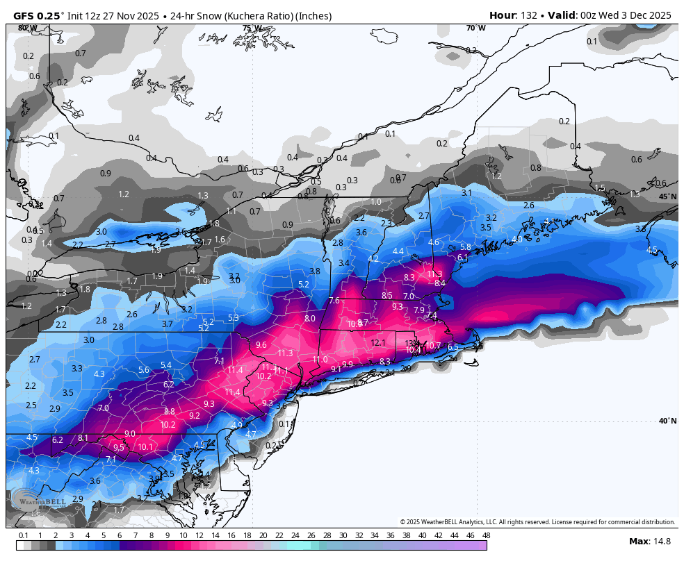
that pink is heavy wet snow, that doesn't show ice
-
Wonder if the 5th has any potential as the GFS has another shortwave take a similar path but looks to get shredded
-
Congrats and Happy Thanksgiving!
-
Ice wise for the southwestern areas it would be freezing rain in the upper 20s so may be legit enough to cause issues.
-

Central PA Fall Discussions and Obs
Blizzard of 93 replied to ChescoWx's topic in Upstate New York/Pennsylvania
12z GFS snow for just Tuesday.
-
Welp...the snow weenies are back on the board. Happy Thanksgiving one and all!
-
Which means it will probably change again lol, but still a nice shift (not trend). We're due for an early December snow day that doesn't include scattered snow showers that take 12 hrs to accumulate a half inch.
-
Central PA Fall Discussions and Obs
Blizzard of 93 replied to ChescoWx's topic in Upstate New York/Pennsylvania

-

December 2025 regional war/obs/disco thread
Typhoon Tip replied to Torch Tiger's topic in New England
This isn’t relaying off the eastern Pacific via a S route/split stream (along the 564) until ~ Sat morning … traversing the continent in 72 hrs in fast compression/progressive flow type. Those circumstances don’t lend to confidence even at this range. The wave space in the field is higher confidence. Something’s there. But smaller giga corrections are like .5 deg on golf ball swing ending up on the left or right side of the fairway at a 200+ yd drive I’m also leery of model-biased amplitude —> correcting down post arrivals out of assimilation regions. Once this relays into the denser sounding array, as we’ve observed more frequently than not … there’s been this recurring theme of correction toward less by 20some % … suggesting an over evaluation was taking place and running that out into mid range results in fantasy. -

December 2025 regional war/obs/disco thread
TauntonBlizzard2013 replied to Torch Tiger's topic in New England
That’s a really solid shift SE on that run. You went from rain to NH to now rain confined for SE Mass -
Not buying. Yet. Go eat some Turkey yall.