All Activity
- Past hour
-
I'll take the 3K and HRRR please.
- Today
-
High of 93.7 yesterday. Honestly I thought we were done with this
-

Invest 94L—40% 2 day and 80% seven day odds of development
TriPol replied to WxWatcher007's topic in Tropical Headquarters
I don;t understand the physics of how Humberto kicks the other system into the east coast. -
 If you’re on the coast from Florida to NC I would be following this closely and make sure you have the ability to prepare if needed. This forecast is as uncertain as it gets relating to a tropical cyclone
 -
I said this yesterday and it holds just as true today but what a crazy TC setup. Some of these model solutions don’t even seem possible with twin strong hurricanes dancing around each other. EPS is concerning as are hurricane models but that being said given the proximity to Humberto, j wouldn’t put stock in ANYTHING until we have a coc and even then the evolution of Humberto will be critical
-
I have 0.11" storm total so far. Hopefully CTP is correct in their big finale forecast this morning Sent from my SM-G970U1 using Tapatalk
-

Invest 94L—40% 2 day and 80% seven day odds of development
GaWx replied to WxWatcher007's topic in Tropical Headquarters
Tropical Weather Outlook NWS National Hurricane Center Miami FL 200 AM EDT Thu Sep 25 2025 Eastern Caribbean Sea (AL94): A tropical wave centered near the Dominican Republic continues to produces widespread disorganized showers and thunderstorms. The wave is expected to move west-northwestward around 10 to 15 mph, spreading heavy rainfall and gusty winds across Puerto Rico and the Dominican Republic through today. The system is then expected to slow down and turn northwestward when it reaches the southwestern Atlantic. A tropical depression is likely to form when the disturbance is in the vicinity of the Bahamas late this week. Interests in Puerto Rico, the Dominican Republic, Haiti, the Turks and Caicos Islands, and the Bahamas should monitor the progress of this system. * Formation chance through 48 hours...medium...50 percent. * Formation chance through 7 days...high...80 percent. Forecaster Bucci -
Invest 94L—40% 2 day and 80% seven day odds of development
GaWx replied to WxWatcher007's topic in Tropical Headquarters
The 0Z EPS is by far the most ominous for the SE US (including some that get into the Gulf) with a whopping ~75% of the members hitting or skimming. Some of these are very weak (not full TCs) while ~1/3 of the hits are strong. -
Invest 94L—40% 2 day and 80% seven day odds of development
GaWx replied to WxWatcher007's topic in Tropical Headquarters
0Z Euro, just like the 0Z CMC, hits Georgetown, SC, on Monday evening (probably because it was further N than Humberto) though it isn’t as strong as the CMC (989 mb per WxBell): So, of major 0Z ops, Euro and CMC hit Georgetown while UKMET, GFS, and Icon stay well offshore.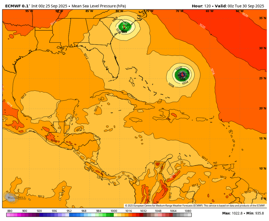
-
 I still think 980 mb is pretty strong, and the outflow of 94L would be dominating against Humberto.
 -

2025-2026 ENSO
Stormchaserchuck1 replied to 40/70 Benchmark's topic in Weather Forecasting and Discussion
I saw that sub-4980dm made it to land about a week ago. I know August broke the record over the arctic circle for lowest heights on record, but then we did it again a week later! That one however, stuck around a little while and moved south over northern Russia sub-4980dm. Impressive for what was Summertime. This +AO phase has been running strong since the Northern Lights made it south in May 2024. September 2025 will probably make it 7 straight +AO months [CPC]. -
2025-2026 ENSO
Stormchaserchuck1 replied to 40/70 Benchmark's topic in Weather Forecasting and Discussion
EPO patterns, both positive and negative, typically happen in only 8-14 day cycles. This is different from the PNA and NAO, which can run in 15-45 day cycles. +15 days after an EPO event actually has a slight opposite correlation to its previous phase, overall (only -0.03 though). -
Today/tonight's rain, which was the highest chance/flood hazard day, is a flop. It didn't rain enough to wet the road under trees here. There may be more upstream but we'll see how heavy it actually is.
-
Invest 94L—40% 2 day and 80% seven day odds of development
GaWx replied to WxWatcher007's topic in Tropical Headquarters
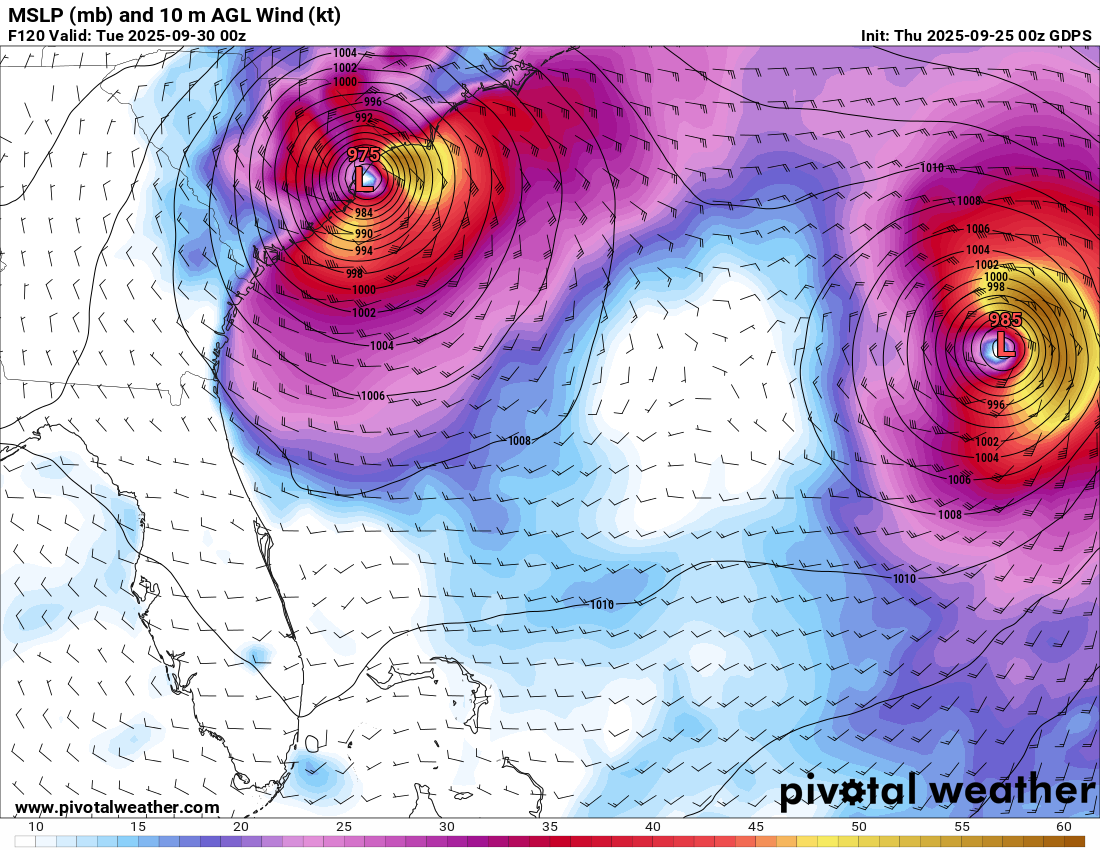
But the 0Z GFS has 94L no stronger than the high 980s while it has Humberto ~25 mb stronger (~963 mb). Were you aware of that? So, considering that, wouldn’t it make sense for Humberto to dominate? -
I am skeptical of the GFS showing a strengthening dangerous hurricane over the Bahamas suddenly being sucked into Humberto. If it were just a wave, sure...but if 94L is a well established hurricane by that time, I highly doubt that it just gets sucked away.
-
Invest 94L—40% 2 day and 80% seven day odds of development
GaWx replied to WxWatcher007's topic in Tropical Headquarters
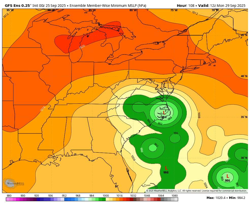
0Z GEFS: the most threatening run yet to the SE US (even more than 18Z):
-

September 2025 OBS-Discussion centered NYC subforum
NorthShoreWx replied to wdrag's topic in New York City Metro
I meant how fast it decreases at airports after it is initially reported. -

Texas 2025 Discussion/Observations
Stx_Thunder replied to Stx_Thunder's topic in Central/Western States
Before taste of Fall wx comes into STX at the end of this week, looks pretty interesting overnight into Thursday with the cool front crawling through the region. Already near 4 in. rainfall just in the past 2 hours right over the Choke Canyon reservoir under a very decent storm cluster looking at storm totals on CRP radar. In the region near SAT where the drought is still the worst in the entire state. PWs as usual this time of year down here pooling > 2 in. ahead of the front. But H5 flow is about 30 knots now, west-northwest on VWP. So starting to see better storm organization and more frequent lightning and even a few powerful +CGs (>100 Kiloamps) on lightning data across the region. Wouldn't rule out a few embedded transient supercells and several inches of rainfall spots overnight with decent mid-upper level support for September standards. Only severe caveat that's been a fairly common TX theme this year (even before summer) is once again, meager ML lapse rates. 'Though, Euro seems to be under-doing them a bit lately. -
Invest 94L—40% 2 day and 80% seven day odds of development
GaWx replied to WxWatcher007's topic in Tropical Headquarters
1. 0Z CMC Georgetown, SC hit with 975 mb H as not as strong Humberto (983 mb) doesn’t dominate: 2. 0Z GFS is safely OTS with Fujiwara from Humberto.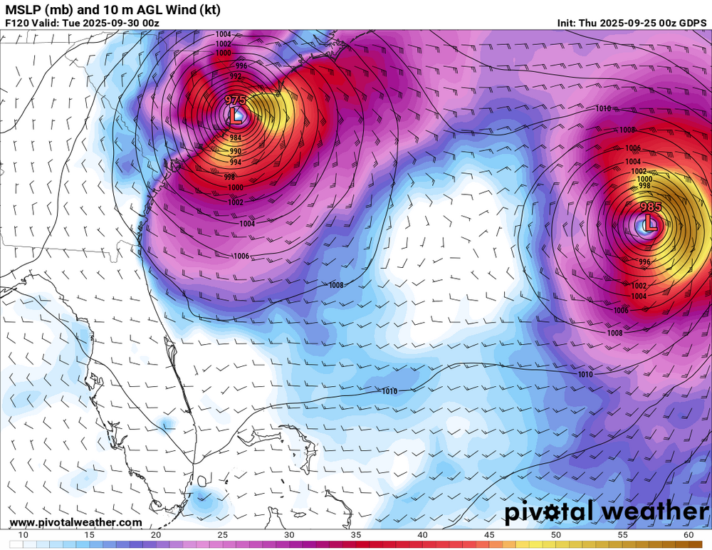
-
Invest 94L—40% 2 day and 80% seven day odds of development
GaWx replied to WxWatcher007's topic in Tropical Headquarters
0Z UKMET: TD forms Mon night NW Bahamas, initially then drifts slowly NW followed by a stall and dissipation as the much stronger Humberto only ~500 miles east takes over: NEW TROPICAL CYCLONE FORECAST TO DEVELOP AFTER 102 HOURS FORECAST POSITION AT T+102 : 25.0N 77.5W LEAD CENTRAL MAXIMUM WIND VERIFYING TIME TIME POSITION PRESSURE (MB) SPEED (KNOTS) -------------- ---- -------- ------------- ------------- 1200UTC 29.09.2025 108 25.9N 78.2W 1008 27 0000UTC 30.09.2025 120 26.1N 78.3W 1007 23 1200UTC 30.09.2025 132 26.1N 78.1W 1007 20 0000UTC 01.10.2025 144 CEASED TRACKING -
Rained a quarter inch in the morning through noon. The morning forecast underestimated the system. But it had been so dry the rain was soaked up quickly and the event was fine to be held. It was hot and humid until the sun went down and then cooled off nicely. .
-
Invest 94L—40% 2 day and 80% seven day odds of development
GaWx replied to WxWatcher007's topic in Tropical Headquarters
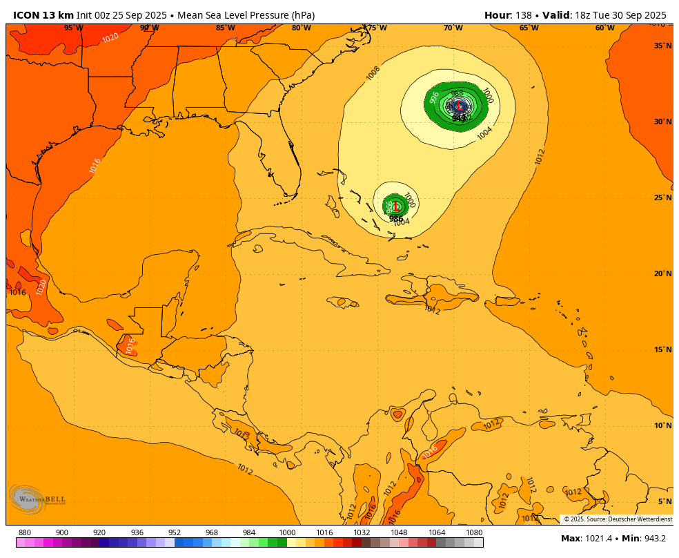
0Z Icon: Humberto pulls 94L ESE to keep it safely away: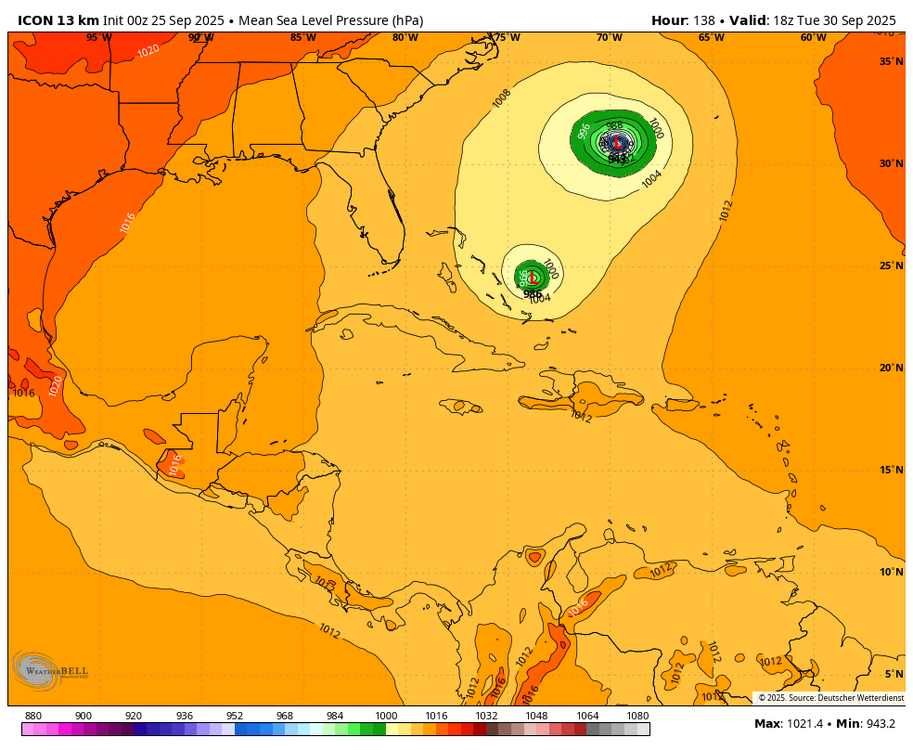
-

E PA/NJ/DE Autumn 2025 Obs/Discussion
KamuSnow replied to PhiEaglesfan712's topic in Philadelphia Region
Raining nicely here, a bit of lightning and thunder. Enjoyable! 0.30" in the last hour. -
Finally getting heavy rain
-
0.95" Didn't think I would see much of anything here until tomorrow.