All Activity
- Past hour
-

November 2025 general discussions and probable topic derailings ...
ma blizzard replied to Typhoon Tip's topic in New England
18z 3k NAM / HRRR on board -

Nov 28-30th Post Turkey Day Wintry Potential
weathafella replied to Chicago Storm's topic in Lakes/Ohio Valley
Clown range 18z NAM shows a trend to have better mid levels. That can really improve output regardless of modeled qpf (which is decent as is). -

Nov 28-30th Post Turkey Day Wintry Potential
Chicago Storm replied to Chicago Storm's topic in Lakes/Ohio Valley
This is a very good and valid point. -

Pittsburgh PA Fall 2025 Thread
PghPirates27 replied to TheClimateChanger's topic in Upstate New York/Pennsylvania
I’d actually take that Euro lol -

December 2025 regional war/obs/disco thread
40/70 Benchmark replied to Torch Tiger's topic in New England
This. -
December 2025 regional war/obs/disco thread
40/70 Benchmark replied to Torch Tiger's topic in New England
Chase this? Jesus, sign of the times... -
December 2025 regional war/obs/disco thread
40/70 Benchmark replied to Torch Tiger's topic in New England
Sell. -
Am at Thanksgiving family dinner. If All goes well one or two threads will begin 9pm tonight or7am Friday. If it’s snow it will be for odds on CP first measurable snow sleet No time to elaborate right now. Have a wonderful family dinner. Walt
-

December 2025 regional war/obs/disco thread
TauntonBlizzard2013 replied to Torch Tiger's topic in New England
I don’t disagree. I won’t believe it until it’s happening. But all we can do is look at modeling today. And some do give us snow. All you can say -

Nov 28-30th Post Turkey Day Wintry Potential
jlauderdal replied to Chicago Storm's topic in Lakes/Ohio Valley
Eye candy that won't materize, GFS does this in the tropics on a regular basis. Heavy rain at my place ahead of a cold front, last rain and 80s I will see for a few days. I'm holding my 7.5 prediction for Western burbs. One more shot to adjust tomorrow. -
We wait until we see the whites of the weenies.
-

Nov 28-30th Post Turkey Day Wintry Potential
Harry Perry replied to Chicago Storm's topic in Lakes/Ohio Valley
Ironically enough I was going to mention this myself as well. Definitely some similarities. -

Nov 28-30th Post Turkey Day Wintry Potential
hawkeye_wx replied to Chicago Storm's topic in Lakes/Ohio Valley
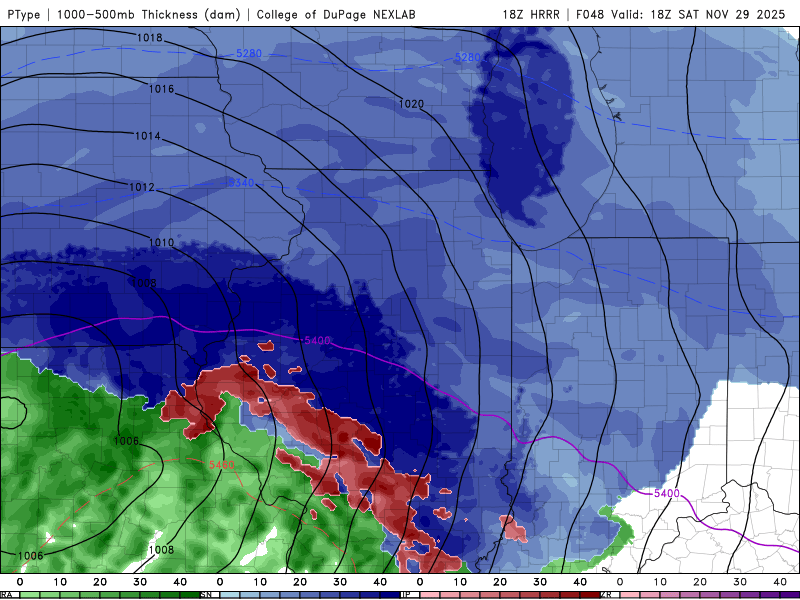
I would, of course, love for the 18z HRRR to be correct, but it is likely too strong and juiced. It has a 1004 mb low, whereas the globals have a 1008-1012 mb low. This HRRR run would probably finish with 16+" in Cedar Rapids, which I very much doubt. Half of that is more likely. The CAMs will probably come back to earth as the start approaches. -

Nov 28-30th Post Turkey Day Wintry Potential
andyhb replied to Chicago Storm's topic in Lakes/Ohio Valley
500 mb evolution with this does remind me a good deal of a slightly less impressive version of GHD II. Trough/jet streak matures in a very similar way and the thermos aren't terribly far off from that either. More likely to taper out with eastward extent though. -
December 2025 regional war/obs/disco thread
TauntonBlizzard2013 replied to Torch Tiger's topic in New England
Meh. After the last 5 years, it would be nice to even be in the game. It’s obviously a flawed setup, but everything is now -
He’s not a snow lover and his comments to me are unusual for him so I’m quite hopeful and 12/5 looks good analog wise
-
It’s a sheared our tilted system, but we’ve seen this before. Doesn’t scream suppression verbatim.
-
December 2025 regional war/obs/disco thread
weathafella replied to Torch Tiger's topic in New England
Widespread snow cover over the northern USA coming. We’re looking at 4-8/6-10 here Saturday and New England similar mid week. I’ll miss the New England event but won’t miss the fun here Saturday. Hopefully more in the pipeline next weekend and beyond. -
Nov 28-30th Post Turkey Day Wintry Potential
Harry Perry replied to Chicago Storm's topic in Lakes/Ohio Valley
Winter storm watch for the entire GRR CWA. Local P&C showing 8” and still snowing by Sunday. Looks like gusty winds in the 30-40 mph range, so blizzard conditions at times. Still some time for the rug to get yanked but I feel pretty confident in a solid 6-10”+ throughout the sub.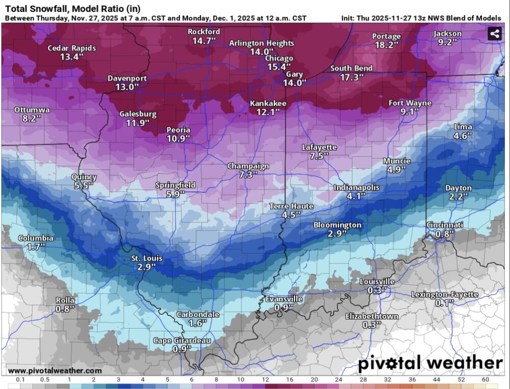
-
Yes... I agree, the look of vort max and its progged track is not one screaming suppression? At least not yet. Its trend (vort max) moving forward is something to watch closely over the next few runs. Nice to see a post focusing on a forecasting issue.
-

December 2025 Short/Medium Range Forecast Thread
Carvers Gap replied to John1122's topic in Tennessee Valley
The 12z Euro trended south and eastward. Overall, was a nice run as was its ensemble. -
Nope, I’m not there. I guess that’s better on 12/2 vs 2/2, but I’ve seen this movie before. Might be a little better for you more inland. 33 snow vs 34 snow.
-

Nov 28-30th Post Turkey Day Wintry Potential
Sciascia replied to Chicago Storm's topic in Lakes/Ohio Valley
Let’s behold it together (thru noon Saturday)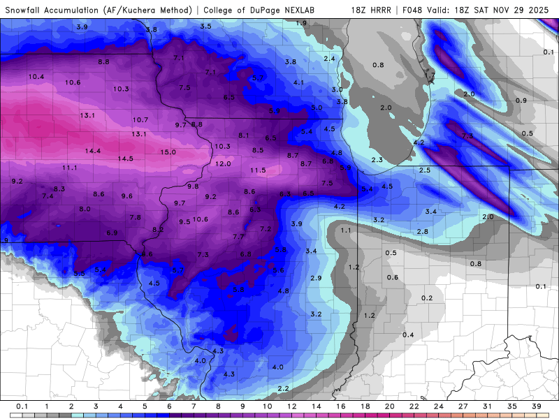
-

December 2025 regional war/obs/disco thread
moneypitmike replied to Torch Tiger's topic in New England
A sign if intelligence is being able to change your mind. -

Nov 28-30th Post Turkey Day Wintry Potential
Baum replied to Chicago Storm's topic in Lakes/Ohio Valley
Hold.


