All Activity
- Past hour
-

December 2025 regional war/obs/disco thread
Ginx snewx replied to Torch Tiger's topic in New England
Please don't Dec 89 us ugh -
12z HRRR brings the smoke.
-
too much pacific energy keeping the pna ridge flattened and ruining an otherwise great pattern
-
The pattern seems like it's about to recycle what we've just gone through the past two or three weeks, but let's hope climo help some others out as we move forward
-

2025-2026 New England Snow Recordkeeping Thread
tunafish replied to bristolri_wx's topic in New England
@bristolri_wx Looks like it's in "View Only" mode. Which boomer didn't close the sheet? -

December 2025 regional war/obs/disco thread
SouthCoastMA replied to Torch Tiger's topic in New England
I went back starting at the 12z run on 11/27..and the Euro actually was pretty close with the track. However, thermals and storm intensity, especially between 11/28-11/30 were way off. Not sure why it would do well with the track and suck at everything else. Going to be a fun winter. -
December 2025 regional war/obs/disco thread
Ginx snewx replied to Torch Tiger's topic in New England
Yes I mean with systems maybe once twice a week it gets stagnant in here. Stir it up and convo gets real. -
I think it’s the usual inflator. Toss it. But I just meant the jackpot zone. There was no epic banding, but the ones we had kept lining up over this area.
-
06z Euro was trying to get some snow into SNE early Saturday....not much, maybe a C-1"...not really buying it. Maybe a few flurries.
-
Well it is run on an original Super Nintendo 64 so they have to keep taking the cartridge out and blowing on it to restart it after certain panels so i get it.
-
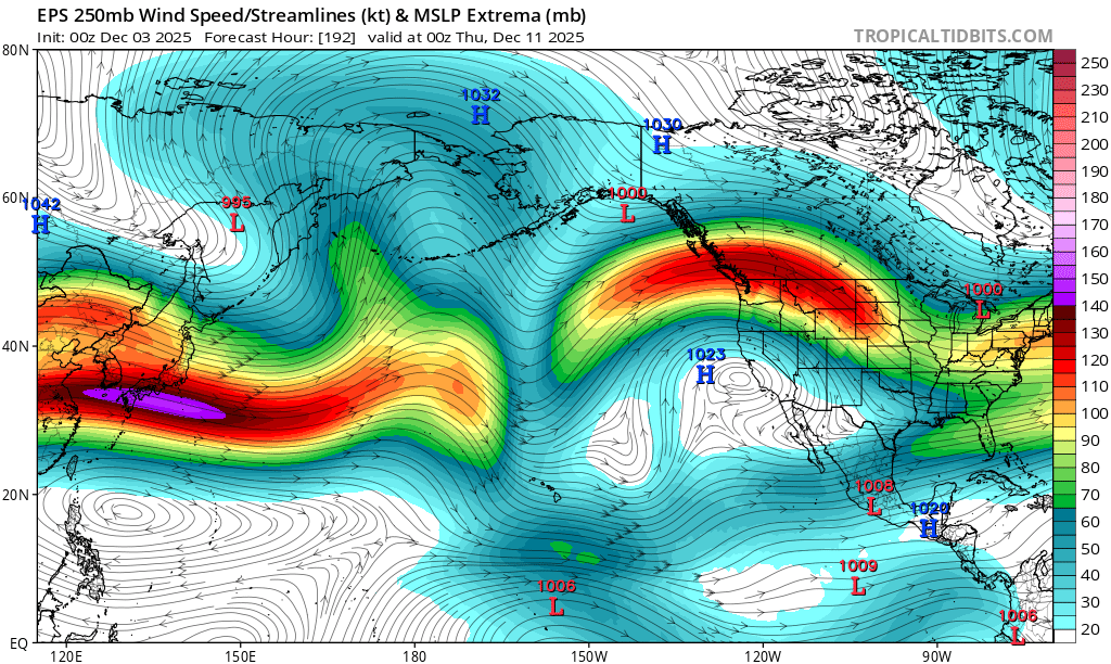
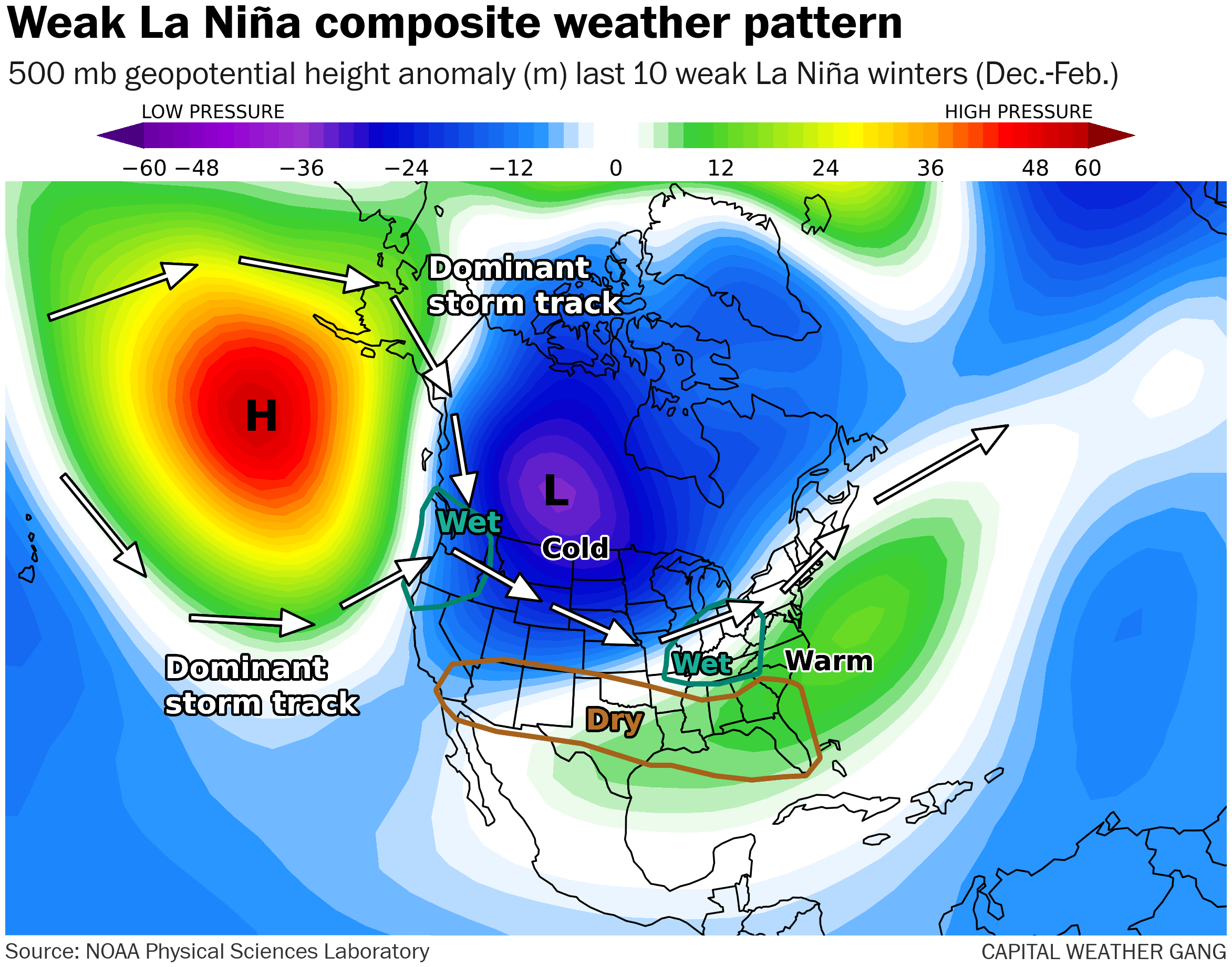
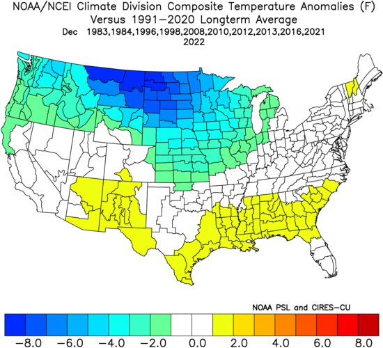
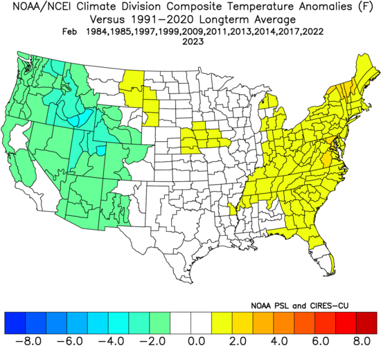
The medium range appears to show a more canonical La Niña pattern than we’ve seen from previous La Niña winters this decade, with a ridge over the GOA, cold in interior western Canada spreading eastward through the Great Lakes. Recent La Niña winters have shown extreme displacement of the North Pacific ridge from what is the typical location, with 2022-2023 featuring the ridge very far west (over the Aleutians), resulting in extremely heavy seasonal snows in the Sierra Nevadas (La Nina is normally dry there). 2024-2025 featured the north pacific ridge displaced much further east than usual, resulting in very high +PNA values and is very atypical for La Niña. It’ll be interesting to see if we experience more extreme displacements of the typical La Niña pattern this coming decade.

-
Through 24, Heights a little better out front and overall better tilt to the trough. Still early
-
Hey Don, If a -PNA verifies for Dec, which is becoming increasingly likely as you’re implying, the chances for a +PNA in Jan are increased based on the last 11 -ENSO -PNA Decs all proceeding to a +PNA Jan. This includes Jans like 1985, 2011, 2014, and 2022. At NYC, ~70% of those Januaries were colder anomalywise than the preceding Dec at NYC. The only 3 Januaries that weren’t were 2011 (which was still cold), 2017 (PNA +0.28), and 2023 (PNA +0.22): Dec: Jan: Feb: @EastonSN+PNA in Dec of 2008 was -1.41 and was +0.61 in the much colder Jan.

-

December 2025 regional war/obs/disco thread
WinterWolf replied to Torch Tiger's topic in New England
Is he hazy, or just downright ignorant. Most here could a better job explaining what happened than that clown. Sad he is a pro…doesn’t sound like it. -
EPS trying to really mute the mid-month torch. No real coherent threats, but a lot of buckshot on the ensembles....I suppose 12/9-10 still has a bit of the clipper/redeveloper sig, but not super strong. It has a system right on its heels...another stronger clipper...could morph into a SWFE....or just be a glorified FROPA. Way too early to really care.
-
It comes out so slow you will make it no matter where you are going lol
-
December 2025 regional war/obs/disco thread
WinterWolf replied to Torch Tiger's topic in New England
I see your point, however some of these people need to have their doors blown in every so often. I have Tiger Torch on ignore, and a few others, but sometimes you see the post anyways, because somebody quoted it. Whatever. On ignore they go. Some silly folks for sure. But let’s carry on with the weather. -
We saw that here in westfield. If you straight measured it like I usually do... I know it's not the right way, then we had about 4.75". The other half measured it right and I can't remember because I'm dead tired from plowing all night but it was more than that here. I think he said around 6"
-
Get it. I’m on the metro and I refuse to do pbp on this damn iPhone. With the pace the NAM comes out, I could make it from here to Waldorf before it gets to the relevant panels.
-

Texas 2025 Discussion/Observations
Stx_Thunder replied to Stx_Thunder's topic in Central/Western States
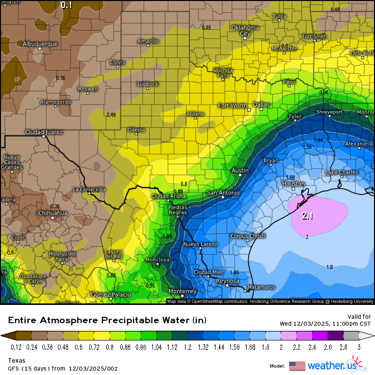
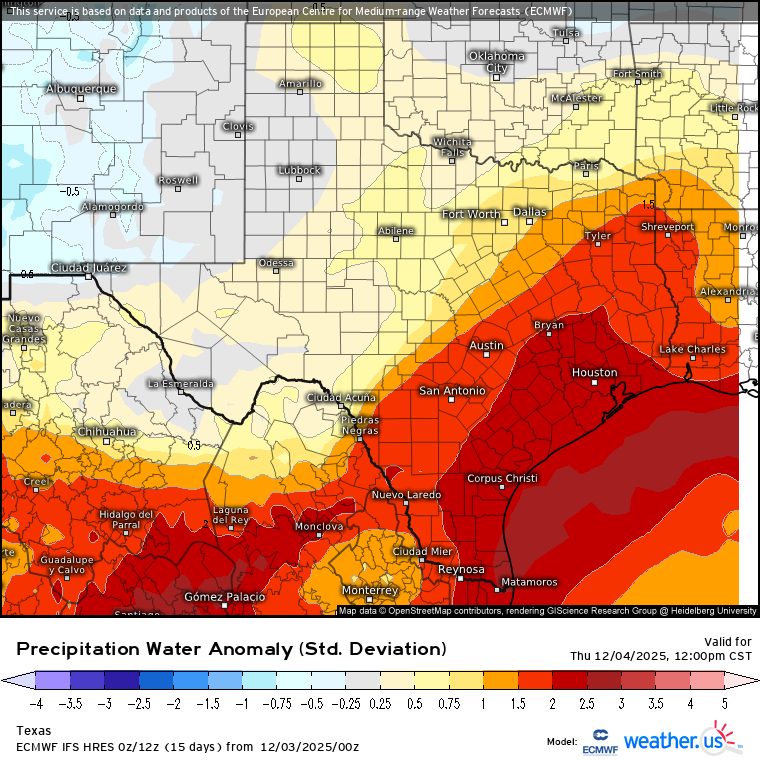
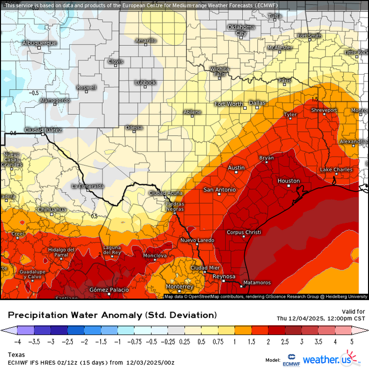
Euro & GFS have been consistent on this since last week, but 2+ in. precipitable water values (way above normal in December) near/over the coast starting late today ahead of the next SS trough out west and typical responding coastal Low pattern. I'll be danged if we still have this late spring/early fall type moisture depth around the coastal region later this month or beginning of 2026. Especially with a warming ENSO (into EN territory) trend now back in the cards.. CPC actually turned out to be right about the formidable ongoing latter phase MJO "destructively" interfering with the typical warm/dry LN pattern on their week 3-4 outlook discussion (in early November).
-
Root for your foothill brethren who missed to the west, south, east, and north last year.
-
This is the way. As i keep saying, this is house money. 2” would be fantastic and a mood booster around here. I just want a steady consistency in the models and fun tracking right now. Lol’d for real. We actually tried that with like 2 storms. We’d make a thread and shit would fall apart. Then a new thread and it trended in our favor. Then people started believing that worked. Fun times
-
So, someone can bitch... but we can't respond?? Makes no sense. If you're going to have one, you've got to have the other EDIT: I should add, it's taken me a very, very long time but I'm starting to realize it's part of the fun here
-
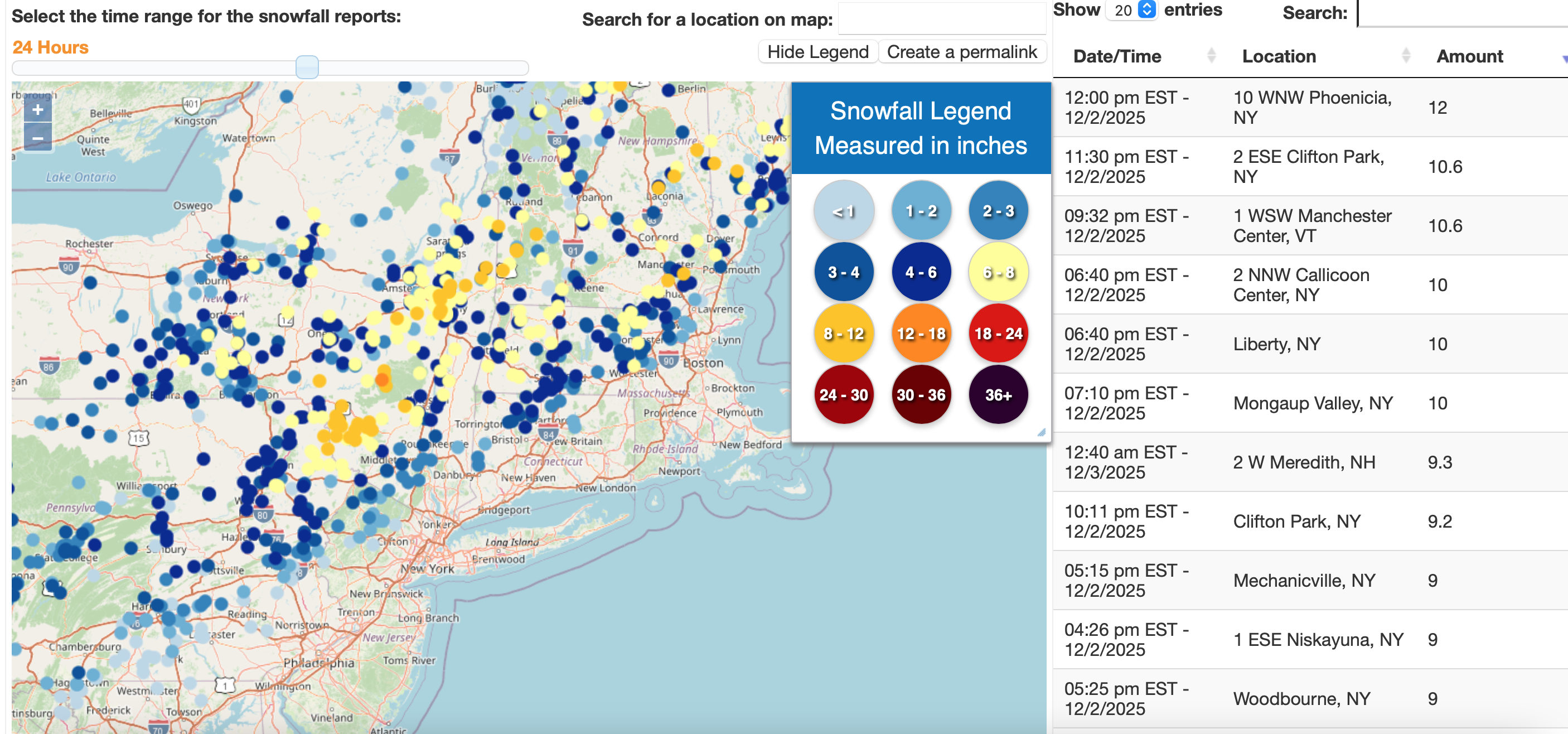
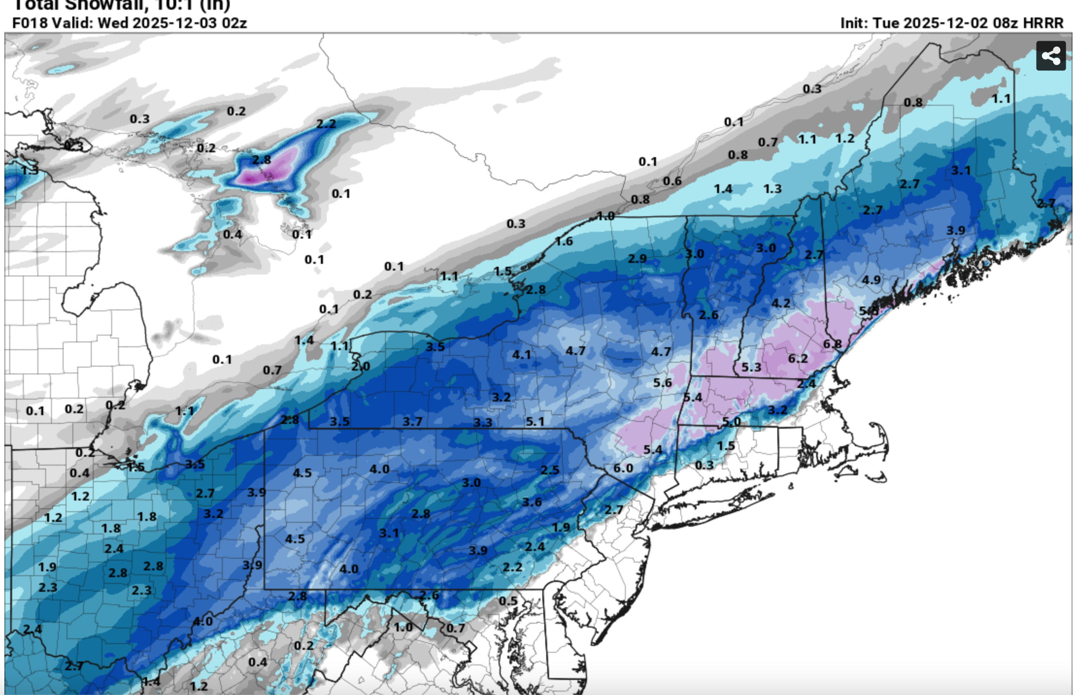
 And my last group of graphics: Check out the 08z/2 HRRR and the resultant snowfall... cherry picked that HRRR but its what I used for a local FB post. Scary good science (at least at times close in).

-
Early on, some positive changes out west on the NAM.