All Activity
- Past hour
-
Finally starting to let up some here as the low is starting to move slowly off to the NE, Up to 2.15" for the event.
-
The coastal band had been perched over my noggin all day.
-

2025 Spring/Summer Mountain Thread
LakeNormanStormin replied to Maggie Valley Steve's topic in Southeastern States
We felt it here on the lake in Cornelius. The whole condo shook for approximately 2-4 seconds. The birds went quiet too. -
Too windy for a perfect 10 but it's really nice out.
-
10/10 today wow wow
-
There is actually a cool bias at times at Newark since the ASOS is right on the water and gets a sea breeze. You will notice several more inland NJ sites having a similar number or more 90° days than Newark does. This is the total 90° count for the 2020s in NJ so far with the Harrison and Hightstown beating Newark for 90° days. 90 day Data for January 1, 2020 through May 9, 2025 Click column heading to sort ascending, click again to sort descending. HIGHTSTOWN 2 W COOP 204 HARRISON COOP 195 Newark Area ThreadEx 183 NEWARK LIBERTY INTL AP WBAN 183 CANOE BROOK COOP 173 FREEHOLD-MARLBORO COOP 170 ESTELL MANOR COOP 169 SOMERSET AIRPORT WBAN 167 CALDWELL ESSEX COUNTY AP WBAN 162 SOUTH JERSEY REGIONAL AIRPORT WBAN 160 New Brunswick Area ThreadEx 154 NEW BRUNSWICK 3 SE COOP 154
-
How many 90 degree days did NYC and JFK have in 2022? That 49 number for Newark seems rather high and doesn't fit the profile of the other summers around it which were hotter. 1983, 1991, 1993, 2010 were all much hotter summers.
-
1983 was a genuinely hot summer, none of these post 2013 summers have been hot like that.
-
to be fair our last really hot summer was 2013, Newark is notorious for having a hot bias. Is this the same low coming back again and again? How long does it take for this thing to dissipate?
-
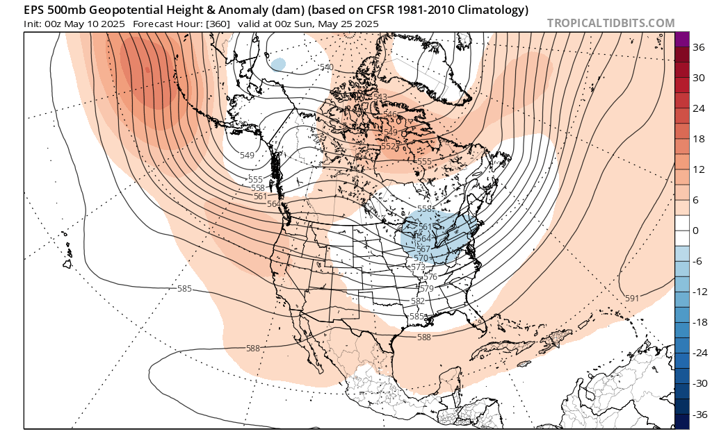
Yeah, we’ll see how it goes. But it does look like 90° potential will probably wait until after the Memorial Day weekend. While recent years had under 40 days at Newark with the first 90° holding off until after June 1st, the last time the first 90° getting delayed into June reached 40 days was 1983. But that was after a super El Niño winter and not a La Niña like this year. The real test will probably come during the last week of May which is beyond the 15 day model range. If a 90° day can’t sneak in that week, then the chances for Newark reaching 40 days this year could be diminished based on the past. All years at Newark with 40 days reaching 90° and the 1st 90° day 2010….54….4-7 2022….49….5-21 1993…..49….5-9 1988….43…..5-31 2021....41……5-19 1991….41……5-12 2016...40…..5-25 1983…40…..6-12 1959….40…..5-12
-
I just left up there, it was nasty driving, I was thinking the same of how nice a snowstorm it would be in winter.
-
This is what is known as a WET STEIN...
-
Notable speed-up in the overnight and morning guidance with the arrival of the rain: initial shower bands may arrive before the dinner hour on Monday.
-
What a drencher here at Pit2. Torrential rain all day so far. Blustery and 47*. What a May. Hopefuilly it'll be dry enough tonight for the first mowing tomorrow morning. The lawn is a jungle.
- Today
-
2.04"
-
Rain has finally almost stopped. Let's get these temperatures up!
-
You wonder in the 5/20 - 5/24 period of any of the building heat to the SW gets up this way ahead of any Memorial Day weekend trough - way out there.
-
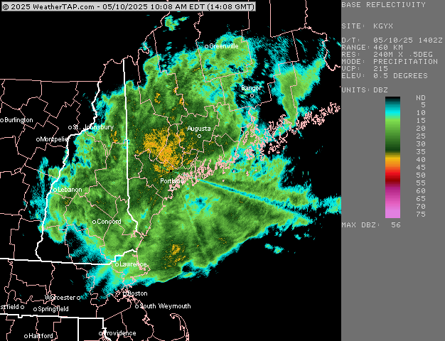
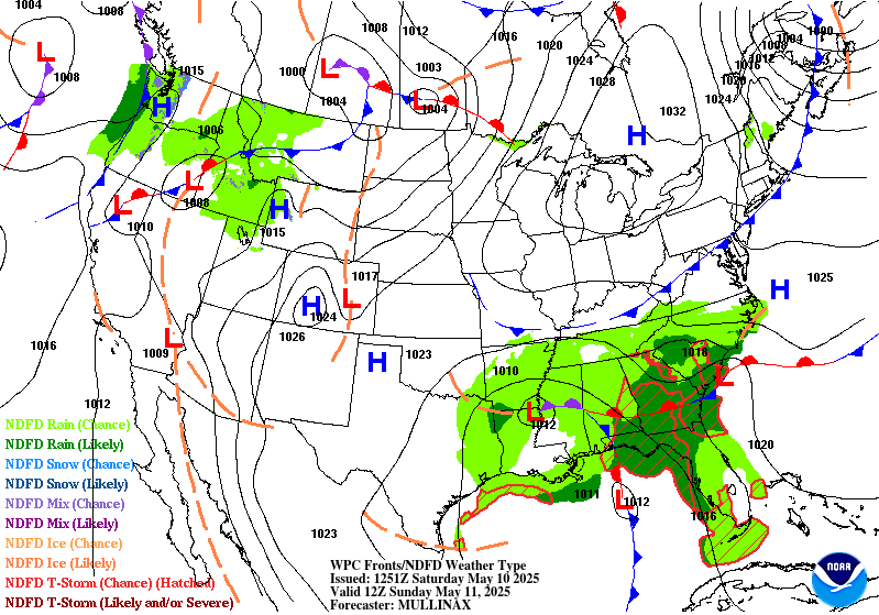
Shocker. Flood Advisory National Weather Service Gray ME 1131 AM EDT Sat May 10 2025 .Widespread rain continues across Maine with up to an additional inch possible through tonight. The runoff will raise streams and rivers, resulting in some minor flooding in low-lying and poor drainage areas. MEC001-005-011-017-023-NHC003-101800- /O.NEW.KGYX.FA.Y.0002.250510T1531Z-250510T1800Z/ /00000.N.ER.000000T0000Z.000000T0000Z.000000T0000Z.OO/ Androscoggin ME-Cumberland ME-Kennebec ME-Oxford ME-Sagadahoc ME- Carroll NH- 1131 AM EDT Sat May 10 2025 ...FLOOD ADVISORY IN EFFECT UNTIL 2 PM EDT THIS AFTERNOON... * WHAT...Flooding caused by excessive rainfall is expected. * WHERE...Portions of Maine, including the following counties, Androscoggin, Cumberland, Kennebec, Oxford and Sagadahoc and northern New Hampshire, including the following county, Carroll. * WHEN...Until 200 PM EDT. * IMPACTS...Minor flooding in low-lying and poor drainage areas. * ADDITIONAL DETAILS... - At 1129 AM EDT, Doppler radar indicated heavy rain due to thunderstorms. Minor flooding is ongoing or expected to begin shortly in the advisory area. - Some locations that will experience flooding include... Lewiston, Auburn, Brunswick, Augusta, Conway, Gardiner, Bridgton, Fryeburg, Mechanic Falls and Turner. PRECAUTIONARY/PREPAREDNESS ACTIONS... Turn around, don`t drown when encountering flooded roads. Most flood deaths occur in vehicles. Flooding is occurring or is imminent. It is important to know where you are relative to streams, rivers, or creeks which can become killers in heavy rains. Campers and hikers should avoid streams or creeks. && LAT...LON 4405 7112 4417 7104 4423 7093 4437 7043 4443 7036 4448 7015 4449 6991 4436 6991 4432 6978 4415 6975 4392 7012 4405 7031 4399 7037 4405 7050 4392 7070 4389 7078 4390 7087 4400 7094 4397 7107 $$ Palmer
-
Brutal. It would’ve been a region wide 6”-12” in Jan/Feb.
-
Relentless
-
Nope, so that was fun setting up in the sheet drizzle. I found some cool antiquities for cheap though. Rain is done here, hopefully we get some clearing.
-
37 this am in Pen Mar.
-
Looks like a delayed first 90° of the season for the warm spots like Newark. Models still have the upper low sitting over the Northeast on Memorial Day weekend. If this forecast does indeed verify, then it could mean that a summer like 2021 and 2022 for over 40 days reaching 90° near Newark may be less likely. This was the case in 2020 with the delayed first 90° into early June signaling fewer 90° days overall. These days Newark needs 40 or more days reaching 90° to be considered to be a high number. First/Last Summary for NEWARK LIBERTY INTL AP, NJ Each section contains date and year of occurrence, value on that date. Click column heading to sort ascending, click again to sort descending. Minimum 04-13 (2023) 08-27 (2020) 81 Mean 05-16 09-11 118 Maximum 06-06 (2020) 10-02 (2019) 147 2024 05-02 (2024) 90 08-28 (2024) 95 117 2023 04-13 (2023) 92 09-08 (2023) 92 147 2022 05-21 (2022) 95 09-04 (2022) 93 105 2021 05-19 (2021) 91 09-15 (2021) 91 118 2020 06-06 (2020) 91 08-27 (2020) 93 81 2019 05-26 (2019) 90 10-02 (2019) 96 128 2018 05-02 (2018) 90 09-06 (2018) 98 126 2017 05-17 (2017) 92 09-25 (2017) 90 130 2016 05-25 (2016) 91 09-23 (2016) 90 120 2015 05-25 (2015) 90 09-09 (2015) 91 106 Time Series Summary for NEWARK LIBERTY INTL AP, NJ - Jan through Dec Click column heading to sort ascending, click again to sort descending. 2024 33 0 2023 29 0 2022 49 0 2021 41 0 2020 31 0 2019 27 0 2018 36 0 2017 22 0 2016 40 0 2015 35 0
-
Pretty good call here with a boundary hanging out along the NW area of the sub. Pretty dry though with just some scattered showers.
-


.thumb.png.4150b06c63a21f61052e47a612bf1818.png)