All Activity
- Past hour
-
Perhaps some, but it's still locally. Not denying there was a stein dent
-
 Yep, long way away but multiple models have Imelda or its remnants somewhere along the East Coast until like 10/10
 -

Invest 94L—80% 2 day and 90% seven day odds of development
wthrmn654 replied to WxWatcher007's topic in Tropical Headquarters
And possibly bring threats further north depending how long it stalls. -
.40" here and just over an inch since Sunday. It doesn't banish Stein but its nice to have.
-
Here it comes: https://weather.cod.edu/satrad/nexrad/?parms=CCX-N0B-1-24-100-usa-rad
-

Invest 94L—80% 2 day and 90% seven day odds of development
GaWx replied to WxWatcher007's topic in Tropical Headquarters
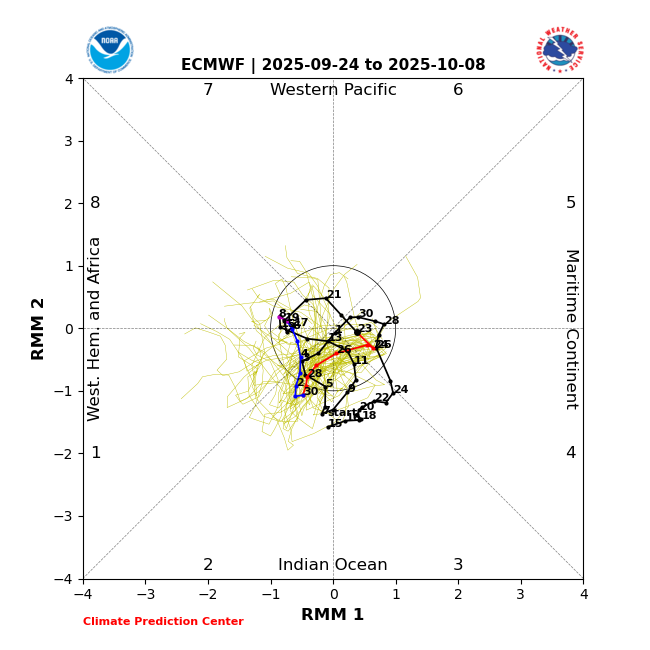
The MJO for 9/27 through 10/3 or 10/4 is again being forecasted by GEFS and EPS to be in phase 2, which is about tied for the most dangerous phase along with 8 for Conus H landfalls and by a large margin has been the most dangerous for Conus MH landfalls (inside or outside the circle). MH Conus landfalls since 1974 during phase 2 -Ida (2021) -Michael (2018) -Irma (2017) -Harvey (2017) -Ivan (2004) -Bret (1999) -Emily (1993) -Hugo (1989) -Frederic (1979) -Eloise (1975) -Carmen (1974) That’s 11 of 29 (38%) of all Conus MH hits since 1974 just during phase 2. These were all during Jul-Oct. During Jul-Oct 1974-2024, 16% of days were in phase 2. So, even after taking into account the fact that the # of days in phase 2 has been about the largest of any one phase along with phase 1, the 38% of all MH hits is still very high. If phase 2 were instead a neutral influence, one would expect the # of MH hits during phase 2 to be only ~3-5. GEFS EPS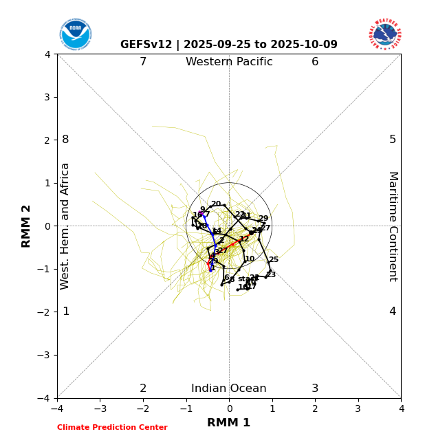
-
Hi all, Reposting Alfredo's bulletin here, "Good afternoon, With apologies for the delay, we are pleased to share the Maryland Climate Bulletin for August 2025, which includes sea surface temperatures for the Chesapeake Bay and the state's coastal waters. You can access the Bulletin from the following link: https://mdsco.umd.edu/Bulletin/bulletin_mdsco_current.pdf Points to highlight are: 1) Statewide averages indicate that August 2025 was colder and drier than normal (i.e., 1991-2020 averages). The statewide temperature was colder than normal (3.0°F below), after warmer-than-normal June and July, for the second time since January. Statewide precipitation was below normal (2.52 inches deficit) in August, following a wetter-than-normal July and a drier-than-normal June. 2) The mean temperature was colder than normal over all the state, particularly over Caroline and Dorchester counties (3.6 to 3.9°F below), and counties in the central Piedmont and coastal plains (3.0 to 3.3°F below). Precipitation was below normal all over the state after the below normal precipitation, particularly from the southern halves of Prince George’s and Anne Arundel counties to Charles, Calvert, and Saint Mary’s counties (3.0 to 3.6 inches deficit), Caroline, Talbot, Dorchester, and western Wicomico counties (3.0 to 3.3 inches deficit), and western Piedmont (2.4 to 2.7 inches deficit). The first of these regions, over the southwestern coastal plain, received between 20 and 30% of its climatological rainfall for the month, while the other two regions, over the Eastern Shore and western Piedmont, got 30 to 40% of theirs. 3) Drought conditions returned to the state in August, with around 70% of the state experiencing Abnormally Dry conditions. Drought-free conditions were present only over Cecil, Harford, Dorchester, and portions of Queen Anne’s, Talbot, Wicomico, Worcester, Allegany, and Garrett counties. Abnormally Dry conditions can be a precursor to drought if rainfall continues to be below normal. The majority of streams and rivers had normal streamflow throughout the state, with a few already showing below-normal streamflow in western Maryland, the central Piedmont, and the southeastern Eastern Shore 4) Statewide maximum daily temperatures from January 1 to August 31, 2025, indicated that the number of days with extreme temperatures has been less than normal. On the other hand, statewide minimum daily temperatures showed that the number of days with extreme temperatures has been larger than normal. There was one less hot day (maximum temperatures larger than 86°F) than normal (43 vs. 44), but one more heatwave than normal (9 vs. 8). There were thirteen more warm nights (minimum temperature larger than 68°F) than normal (38 vs. 25), and a normal number of warm night spells (5) by the end of August. 5) Statewide daily total precipitation from January 1 to August 31 showed a normal number of days with extreme precipitation (12; at least 0.64 inches; the 95th percentile in 1951−2000), with the last one occurring on August 1. The number of dry spells (two or more consecutive days with daily precipitation of no more than 0.04 inches) was fewer than normal by five spells (28 vs. 33), with three of them occurring in August. 6) The cumulative calendar year (January 1 to August 31) modified growing degree days (base 86/50°F) reached 3219°FDD by the end of August and have been greater than normal since the second week of March, with a departure above normal of 190°FDD. The curve of the cumulative modified growing degree days in the summer months was very similar to that of last year and is among the most extreme on record since 1951. 7) Statewide mean, maximum, and minimum temperatures (71.8, 81.6, 62.0°F) indicated that August 2025 was the twenty-fifth, nineteenth, and thirty-seventh coldest August since 1895, respectively. Three counties experienced maximum temperatures among the ten coldest on record: Calvert had its eighth coldest, while Dorchester and Saint Mary’s had their ninth coldest 8) Statewide precipitation (1.66 inches) showed that August 2025 was the seventh driest August since 1895. Thirteen counties had rainfall within the ten driest, and nine of them within the five driest on record: Carroll and Frederick counties had their driest August; Charles had its second driest, Saint Mary’s had its third driest, Calvert had its fourth driest, while Anne Arundel, Garrett, Montgomery, and Prince George’s had their fifth driest. 9) Sea surface temperatures in the Chesapeake Bay in August 2025 were below their 2007-2020 mean. The coldest anomalies were found in the southeastern Lower Bay, including the Tangier Sound waters along the coasts of Somerset, Wicomico, and Dorchester counties, as well as in the narrow strip of water in front of Worcester County’s Sinepuxent Bay (1.8‒2.7°F below). The current all-basin mean temperature of 79.5°F was far from the coldest August temperature in the 19-year data set (2007-2025), which was 77.8°F in 2013. Please refer to the bulletin for more details, including information on century-long trends and links of interest. The bulletin is issued once per month and shows the state's recent monthly surface temperature and precipitation conditions in a simple format, helping Marylanders better understand regional climate variations. This bulletin is possible thanks to the hard work and data made available by our friends at NOAA National Centers for Environmental Information, CoastWatch East Coast Node, the Institutions involved in the U.S. Drought Monitor, and the U.S. Geological Survey's Water Watch. Please help disseminate this bulletin. .................. Alfredo Ruiz-Barradas, PhD Associate Research Professor Maryland State ClimatologistDepartment of Atmospheric and Oceanic Science
-

E PA/NJ/DE Autumn 2025 Obs/Discussion
LVblizzard replied to PhiEaglesfan712's topic in Philadelphia Region
Hmmm, a bit of sunshine starting to break out here with the line of storms still west of Harrisburg. Hopefully this can destabilize the atmosphere enough for something good. -
Mmmm, gyros.
-
.55 for the event. Should about do it . Kind of a stein but after wet summer that’s ok
-
-

Invest 94L—80% 2 day and 90% seven day odds of development
Krs4Lfe replied to WxWatcher007's topic in Tropical Headquarters
I'm getting stron Joaquin vibes from this one. Except Joaquin was strong when passing through the Bahamas, but then it stalled as it passed through Bahamas and then kicked out to see, but it's moisture flooded the Carolinas big time. With Humberto nearby, I think that would act as a mechanism to tug Imelda out to sea. However, with Joaquin, there was a trough heading through the east US and Joaquin stalled over Bahamas which allowed trough to arrive in time to bring it out to sea. -
Way too early
-
 The visualization with the moving dots is fantastic.
 -
i am just shy of an inch here, and with what looks to be some decent precip on radar. radar trajectory looks like you will get the goods eventually. i'd be surprised if either of you ended up with <1.5"
-
True, it might be kind of a wash since really the proximity is what matters and slower latitude gain for Humberto cancels out the greater proximity from Humberto being further west. Some of the crazy-looking model solutions where Imelda gets right to the coast, cuts East, then loops back around as Humberto races out to sea actually do kind of make sense and would almost certainly bring serious flooding to the Carolinas
-
lock it in.
-
doesnt eastern IO forcing have the highest correlation to +WPO?
-
Stein gone for all. Webbed hands slowly releasing and hanging down. Like the Alien arm at the end of War of the Worlds.
-
Half inch up here so far. Just a nice soaking rain.
-
 Hammering home the point that—for anyone lurking—even with the trend from the Euro and GFS, there is still a **high** amount of uncertainty on eventual track and intensity. Nothing is locked in yet.
 -
Invest 94L—80% 2 day and 90% seven day odds of development
GaWx replied to WxWatcher007's topic in Tropical Headquarters
But wouldn’t a further W track of Humberto mean a slower latitude gain, which would then mean a higher chance for 94L to get N of Humberto’s latitude and would thus reduce the chance for 94L to get pulled OTS by Humberto? I hope not but am wondering. -
NHC at 2pm: Disturbance 1: 90% Chance of Cyclone Formation in 7 Days As of 2:00 PM EDT Thu Sep 25 2025... Central Caribbean Sea and Southwestern Atlantic (AL94): Showers and thunderstorms are increasing in association with a a tropical wave located near Hispaniola and the Turks and Caicos Islands. An area of low pressure is expected to form along the wave tonight or early Friday when it moves near the southeast Bahamas. This low is expected to become a tropical depression when it is in the vicinity of the central and northwest Bahamas late Friday or over the weekend and then track northwestward or northward over the southwestern Atlantic. Interests in the Dominican Republic, Haiti, the Turks and Caicos Islands, and the Bahamas should monitor the progress of this system. Regardless of development, heavy rains and gusty winds are likely across that region during the next couple of days. While there is significant uncertainty in the long-range track and intensity of the system, the chances of wind, rainfall, and storm surge impacts for a portion of the southeast U.S. coast are increasing. Interests in that area should monitor the progress of the system. * Formation chance through 48 hours...high...80 percent. * Formation chance through 7 days...high...90 percent.
-
Invest 94L—80% 2 day and 90% seven day odds of development
wthrmn654 replied to WxWatcher007's topic in Tropical Headquarters
Found Google ai tropical cyclone models page, with plots and interactive for anyone interested. Make sure you click the menu menu button top left to turn on or off more settings pots etc. https://deepmind.google.com/science/weatherlab -
Invest 94L—80% 2 day and 90% seven day odds of development
GaWx replied to WxWatcher007's topic in Tropical Headquarters
The 12Z EPS, while still scary for the SE US with ~60% hitting and ~50%+ of those hitting being strong TS+, isn’t quite as ominous as the 0Z, which had ~75% hitting the SE. About 40% of members are strongly affected by Fujiwhara with Humberto.


